More From Contributor
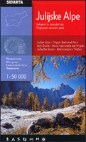
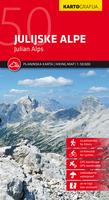
£12.99
Accompanying the six-part BBC 2 series, the six walks featured in this book follow the old tracks, overgrown cuttings & ancient viaducts which are the legacy of ' The Beeching Axe'. Julia Bradbury looks at how the rise & fall of the railways has altered the lives of communities across the country. Today, many of the thousands of old branch lines which were closed in the 1960s are now the treasured stomping grounds of ramblers & hikers. This book follows six of these beautiful walks, all offering an insight into Britain's industrial heritage: the Monsal Trail in Derbyshire, Dolgellau to Barmouth in Snowdonia, Cornwall's Coast to Coast Trail, the Strathspey Railway, Weymouth to Portl&, & Callander to Loch Tay in Perthshire. Fully illustrated with maps & photographs of Julia walking the routes & the spectacular surrounding landscapes, Julia Bradbury's Railway Walks will inspire you to don your walking boots & explore Britain's lost rail empire. The book covers six different walks: 1. Derbyshire- The Monsal Trail 2. Snowdonia
- Dolgellau to Barmouth 3. Cornwall
- Coast to Coast Trail 4. Speyside
- The Strathspey Railway 5. Weymouth
- Harbouring History 6. Perthshire
- Callander to Loch Tay


...
Archived Product
£14.99
The companion to the BBC series Wainwright Walks, with Julia Bradbury following in the footsteps of famous fell-walker & guide writer AW Wainwright. The series

Includes::
beautiful aerial sequences of Lakeland icons Blencathra & England's tallest mountain Scafell Pike. It was first broadcast in 2008 & regularly repeated on BBC4 & BBC2, most recently in December 2011. The book collects together all ten of the walks from Series I & II, with clear directions & Julia's commentary on her experience of the walks. Stills from the original series are augmented by the famous line drawings from Wainwright's original books, & evocative landscape photography by Derry Brabbs.

...
Archived Product
£14.99
The much-loved fellwalker Alfred Wainwright created one of the truly great walking challenges
- to walk across the whole of Engl&.
...
Archived Product
£6.99
Julia & Simca are two young friends who agree that you can never use too much butter
- & that it is best to be a child forever.
...
Archived Product
£29.95
One of the maps in the topographic survey of Peru from the country’s national survey organization, Instituto Geográfico Nacional. Contours are at 25m intervals & colouring/symbols indicate different types of terrain & vegetation. Some of the maps may contain small blank spaces representing as yet unmapped areas. Each sheet covers 30’ latitude by 30’ longitude. The maps have a 1km UTM grid & margin ticks for latitude & longitude at intervals of 1’. Publication dates vary; most maps were published in 1960s to 1990s, with some sheets revised more recently. Map legend is in Spanish only, except in the more recent editions which also include English. ...
Archived Product
£14.99
Julian Alps in a series of double-sided maps at 1:40, 000 from Kartografija in Ljubljana, accompanied by a 71-page bilingual Slovenian/ English colour booklet with 42 pages of descriptions of the region’s numerous places of interest, plus brief descriptions of 44 recommended hiking trails & of 9 cycling routes, from 8.5km to 48km long & accompanied by route profiles. The maps in this series have contours at 20m intervals, enhanced by relief shading & graphics to provide a very effective picture of the topography. Waymarked hiking trails & cycling routes are prominently highlighted & cross-referenced to their descriptions in the accompanying guides. A wide range of symbols provide information on various types of accommodation (rural hotels, motels, farms, mountain huts, campsites), recreational facilities, picturesque locations, etc. For drivers, locations of petrol stations are marked. Each map is double-sided, with a good overlap between the sides, & has latitude & longitude lines at 2’ intervals. The accompanying pocket guides are bilingual, Slovenian/ English, with around 60 to 80 pages. Approx. half are descriptions of places of interest, illustrated by colour photos. Descriptions of hiking routes give timings & the degree of difficulty, as do notes for cycling routes which are also accompanied by route profiles. Also provided is a list of mountain huts. Map legends & all the text include English. ...
Archived Product
£9.99
Julian Alps at 1:50, 000 on a GPS compatible, contoured hiking map from Sidarta with on the reverse details of 41 mountain huts, each annotated with main trails leading to it; also climbing areas, natural heritage sites, etc. The map covers the whole of the Triglav National Park, extending beyond its boundary to the Austrian border, Bled & beyond Tolmin. In the north-west the Italian Julian Alps is included, with place names shown with their Slovenian versions. The map has contours at 20m intervals (25m in Italy), enhanced by relief shading & graphics, plus numerous spot heights & names of peaks & other geographical features. An overprint highlights waymaked trails, grading them according to the degree of difficulty. Locations of mountain huts are prominently marked & other symbols also show campsites, bivouac places, hunting lodges, climbing areas, natural places of special interest, etc. For drivers, locations of petrol stations are also marked. The map has a 1-km UTM grid. On the reverse is information about 41 mountain huts, each illustrated by a drawing, plus full contact details, number of beds & seasonal opening months. Each hut has a diagram of showing hiking routes leading to it from other huts, peaks or car parks. Most are also illustrated with panorama drawings showing the relevant hiking routes. Also provided is a list of climbing areas, plus lists of cultural or natural heritage places of interest annotated with their GPS waypoints. Map legend & all the relevant text include English. ...
Archived Product
£11.99
Julian Alps hiking map by Kartografija at a scale of 1: 50, 000. The map

Includes::
GPS coordinates & is printed

...
Archived Product
£10.99
Julian & Kamnik (Steiner) Alps at 1:75, 000 on a GPS compatible, double-sided, waterproof & tear-resistant map from Kompass in their series covering Northern Slovenia & the country’s coast, with hiking & cycling routes plus extensive tourist information. Cartography, different in style to that used in Kompass’s extensive hiking series covering other parts of Europe, has contours at 20m intervals, although faint colouring means that effectively only main countours at 100m are visible, & even those are sometimes not easy to see. The maps also have relief shading, plus plenty of spot heights & names of peaks & mountain ranges. An overprint highlights hiking routes, indicating difficult sections & showing, where appropriate, the numbers of the trans-European & Slovenian long-distance hiking routes. Also marked are cycling routes & a very wide range of symbols highlight places of interest, different types of accommodation including campsites & agritourism farms, sport & recreational facilities, etc. Road network indicates locations of petrol stations. Railways are shown with stations & different types of mountain lines (cable cars, chair lists, etc.) are marked. The maps have latitude & longitude lines at intervals of 2°30’. Map legend, conveniently placed on both sides of each map,

Includes::
English. Somewhat old-fashioned style of cartography with a variety of type faces & extensive use of italics will appeal to all those who like their maps “as they used to be”! To see the other titles in this series please click on the series link.

...
Archived Product
£10.50
Map No. 064, Julian Alps
- Triglav
- Bled, printed on strudy waterproof & tear-resistant plastic paper, in a series of hiking

...
Archived Product

Julian Alps

Julian Alps at 1:50, 000 on a GPS compatible, contoured hiking map from Sidarta with on the reverse details of 41 mountain huts, each annotated with main trails leading to it; also climbing areas, natural heritage sites, etc. The map covers the whole of the Triglav National Park, extending outside its boundary north to Kranjska Gora and the Austrian border, east to Bled, and south beyond Tolmin. In the north-west the Italian Julian Alps are included, with place names shown with their Slovenian versions.The map has contours at 20m intervals (25m in Italy), enhanced by relief shading and graphics, plus numerous spot heights and names of peaks and other geographical features. An overprint highlights waymaked trails, grading them according to the degree of difficulty. Locations of
mountain huts are prominently marked and other symbols show campsites, bivouac places, hunting lodges, climbing areas, natural places of special interest, etc. For drivers, locations of petrol stations are also marked; the map also indicates local bus stops. The map has a 2-km UTM grid. On the reverse is information about 41 mountain huts, each illustrated by a drawing, plus full contact details, number of beds and seasonal opening months. Each hut has a diagram of showing hiking routes leading to it from other huts, peaks or car parks. Most are also illustrated with panorama drawings showing the relevant hiking routes.Also provided is a list of climbing areas, plus lists of cultural or natural heritage places of interest annotated with their GPS waypoints. Map legend and all
the relevant text include English.
RIP - This product is no longer available on our network. It was last seen on 25.09.2019

This page now acts as a permanent archive for this product. Add more information using the comments box below to ensure it can still be found by future generations.

Use our search facility to see if it is available from an alternative contributor.
  • Availability: Out Of Stock
  • Supplier: Stanfords
  • SKU: 3830008646309
Availability: In Stock
£9.99

Product Description

Julian Alps at 1:50, 000 on a GPS compatible, contoured hiking map from Sidarta with on the reverse details of 41 mountain huts, each annotated with main trails leading to it; also climbing areas, natural heritage sites, etc. The map covers the whole of the Triglav National Park, extending outside its boundary north to Kranjska Gora & the Austrian border, east to Bled, & south beyond Tolmin. In the north-west the Italian Julian Alps are included, with place names shown with their Slovenian versions. The map has contours at 20m intervals (25m in Italy), enhanced by relief shading & graphics, plus numerous spot heights & names of peaks & other geographical features. An overprint highlights waymaked trails, grading them according to the degree of difficulty. Locations of mountain huts are prominently marked & other symbols show campsites, bivouac places, hunting lodges, climbing areas, natural places of special interest, etc. For drivers, locations of petrol stations are also marked; the map also indicates local bus stops. The map has a 2-km UTM grid. On the reverse is information about 41 mountain huts, each illustrated by a drawing, plus full contact details, number of beds & seasonal opening months. Each hut has a diagram of showing hiking routes leading to it from other huts, peaks or car parks. Most are also illustrated with panorama drawings showing the relevant hiking routes. Also provided is a list of climbing areas, plus lists of cultural or natural heritage places of interest annotated with their GPS waypoints. Map legend & all the relevant text include English.

Reviews/Comments

Add New

Price History

Vouchers

No voucher codes found.
Do you know a voucher code for this product or supplier? Add it to Insights for others to use.

Facebook

Jargon Buster

GPS - Global Positioning System - Global position using satellites
Hiking - An outdoor activity envolving walking in nature
Italian - A word used ot descibe something from Italy
Graphics - A general term for visual aspects of an item/display
Car - A machine used for transport which runs on roads
Natural - not manmade
Italy - a country in Europe.
Km - Kilometre. A unit of measurement equal to 1000 metres.
Degree - An angle measurement, also can be the measurement of an extent that something happens, can also relate to an university academic measurement.
degree - The extremity of something or the angle. Can also relate to a university achievement.

Supplier Information

Stanfords
Stanfords was established in 1853 and opened their iconic Covent Garden flagship store in 1901. They have become the top retailer of maps, travel books and accessories in the UK and arguably offer the largest selection of maps and travel books worldwide. Famous names such as Captain Robert Falcon Scott, Ranulph Fiennes and Michael Palin have purchased from Stanfords. They now have a shop in Bristol and both stores together with other venues operate a calendar of events including talks, book signings and exhibitions. As a specialist map retailer, the map selection is comprehensive and includes road maps, street maps and walking maps from worldwide destinations, as well as a selection of world atlases and wall maps. Books include travel guides and travel literature. Stanfords also stock globes, from miniatures made of blue marble to magnificent floor-standing globes. The website features a selection of interesting articles on travel topics.
Page Updated: 2023-11-12 20:15:36

Community Generated Product Tags

Oh No! The productWIKI community hasn't generated any tags for this product yet!
Menu