
 United Kingdom
 France
 Germany
 Netherlands
 Sweden
 USA
USA
 Italy
Italy
 Spain
Spain
More From Contributor


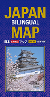
Japan Bilingual Map
Japan at 1:1, 500, 000 on a bilingual road map from Kodansha International, with mapping of the whole country presenting its topography, plus on the reverse more detailed maps of the more densely populated areas. On one side is a map of the whole country at 1:1, 500, 000 with Hokkaido shown as a separate inset. Several more insets cover the outlying island groups including Okinawa. A general overview inset shows the whole country with its islands plus the neighbouring parts of the Asian mainland. All place names are shown in both Latin and Japanese alphabets.Bold altitude colouring combined with relief shading, plus spot heights and names mountain ranges, etc, present the topography. The map clearly shows the Expressways
Product Description
Reviews/Comments
Add New
Intelligent Comparison
Archived Product
Japan Bilingual Map Stanfords
£12.99
Archived Product

Japan Bilingual Atlas Stanfords
£21.00
Vouchers
No voucher codes found.
Do you know a voucher code for this product or supplier? Add it to Insights for others to use.
Do you know a voucher code for this product or supplier? Add it to Insights for others to use.
 Denmark