
 United Kingdom
 France
 Germany
 Netherlands
 Sweden
 USA
USA
 Italy
Italy
 Spain
Spain
More From Contributor


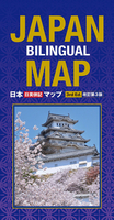
Japan Bilingual Map
Japan at 1:1, 500, 000 on a bilingual road map from Kodansha International, with mapping of the whole country presenting its topography, plus on the reverse more detailed maps of the more densely populated areas. On one side is a map of the whole country at 1:1, 500, 000 with Hokkaido shown as a separate inset. Several more panels cover the outlying island groups including Okinawa. A general overview inset shows the whole country with its islands plus the neighbouring parts of the Asian mainland. All place names are shown in both Latin and Japanese alphabets.Bold altitude colouring combined with relief shading, plus spot heights and names mountain ranges, etc, present the topography. The map clearly shows the Expressways; National Highways are included but in the more mountainous
parts of the country not always easy to see on the bright relief colouring. Railways distinguish between the Shinkansen Bullet Train, JR and private lines. Ferry routes are also marked. The map highlights various places of interest. Latitude and longitude lines are marked at 2° intervals, with an indexed, arranged by the transliterated names, provided in a separate booklet. On the reverse are enlargements of the country’s more populated areas: Kanto (which includes Tokyo and Yokohama), Fukuoka, and Chukyo (around Aichi) – all at 1:400, 000, plus Kansai (with Osaka and Kyoto) at 1:200, 000. The road and rail networks here is presented on plain light background so much easier to see and include secondary and minor local roads.* PLEASE NOTE: many place names, particularly of
smaller towns, geographical features, national parks and places of interest are in very small font size.

Product Description
Reviews/Comments
Add New
Vouchers
No voucher codes found.
Do you know a voucher code for this product or supplier? Add it to Insights for others to use.
Do you know a voucher code for this product or supplier? Add it to Insights for others to use.
 Denmark