
 United Kingdom
 France
 Germany
 Netherlands
 Sweden
 USA
USA
 Italy
Italy
 Spain
Spain
More From Contributor


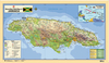


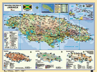
Jamaica Wall Map LAMINATED
The revised edition of this best-selling wall map includes many new features including three new thematic maps covering Population, Land Use and Economic Activity, and a terrain model of Jamaica as viewed from the south-east of the island. The map also provides information on ocean depths, physical features, administrative divisions, settlement (by population size), transport and communications, as well as an inset map of the Caribbean region. Altitude is indicated by a combination of contour layer colouring and hill-shading giving the island an attractive 3D appearance.

Product Description
Reviews/Comments
Add New
Vouchers
No voucher codes found.
Do you know a voucher code for this product or supplier? Add it to Insights for others to use.
Do you know a voucher code for this product or supplier? Add it to Insights for others to use.
 Denmark