More From Contributor
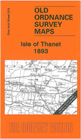
£12.99
Produced in association with the Ramblers, this walking guide covers the beautiful Isle of Skye & combines detailed route descriptions with information on the local history & wildlife. This famous corner of the Scottish Highlands & Islands is home to a spectacular variety of mountain landscapes & dramatic coastlines. There is also a wealth of fascinating places to explore: caves & sea stacks, headlands & arches, waterfalls & castles. The introduction gives information about the topography, geology & history of the area, & describes the flora & fauna inhabiting it. / The main section of the book comprises 30 walks, suitable for all abilities, from young children to experienced walkers. Each walk has a key illustrating principal features, such as level of difficulty & type of terrain, a route profile indicating altitude & distances, as well as a fact file summarising useful information, such as start & finish points, duration, safety advice & points of interest. / Illustrated with colour maps from the Ordnance Survey each walk is then described in detail with clear, easy-to-follow instructions. The text gives the history of the main landmarks along the way & information about the natural history of the area, & is accompanied by stunning colour photographs. NEW FOR 2010 / Overview map on inside front cover showing start points of the walks. / Walks are colour coded to indicated level of difficulty: green for the simpler walks, then amber for moderate walks, then red for the more challenging walks aimed at more experienced walkers. / Front cover flap contains the key to symbols used in the text & on the route maps. Ideal as a book mark during use. ...
Archived Product
£6.99
The Isle of Skye (or Ant-Eilean Sgitheanach in its native Gaelic tongue) occupies an almost mythical place in the minds of many Scots. Romantic castles, magnificent sea-scapes, the alpine peaks of the Cuillin Ridge, marching pipe bands, scattered white crofters` cottages & a bloody history; the island has all these & more. This book features 40 moderate walks that take in much of this celebrated landscape, but reveal hidden gems too. In spite of its popularity Skye is still rich in undiscovered treasures, from coastal caves & arches, ruined villages cruelly cleared of their inhabitants, to fossilised dinosaur footprints & a rich array of wildlife. Written by Skye residents Paul & Helen Webster, these walks will reveal both the wild & gentler sides of this dramatic landscape. ...
Archived Product
£14.95
This guidebook describes 87 of the best walks & scrambles on the Isle of Skye. Not only limited to the popular routes on the Black Cuillin or Skye`s 12 Munros, the guide offers a comprehensive selection of routes in all areas of the island; in Sleat & South-East Skye, Strath, Minginish, Duirinish, Waternish & Trotternish. The routes range in length from 2 to 23km, so while there are opportunities for novice walkers, routes can also be combined for longer trails & difficult scrambles. Skye can delight walkers & scramblers at every turn, from sea stacks to fell tops; corries to rugged cliffs & plenty in between. Walkers on Skye should be prepared for strenuous trails & wilderness, as well as changeable weather, navigation, &
- depending on the route
- scrambling skills. However, the routes in this guide range in length from 2 to 23km, so while there are opportunities for novice walkers, routes can also be combined for longer trails & difficult scrambles. Alongside detailed descriptions & OS maps for every route, the guidebook also

Includes::
practical information essential to making the most out of a visit to Skye. From travel to & around the isl&, to advice on accommodation, where to stock up on supplies & who to call in emergencies. The result is an excellent companion to exploring the best of Skye.


...
Archived Product
£9.99
This is an alternative guide to the wildlife & geology of Skye detailing where to see the island`s lesser-known natural history. There are 20 walks based aroud Portree, Dunvegan, Broadford & Sleat together with detailed maps & quality photographs. ...
Archived Product
£4.99
The Nicolson Isle of Skye Tourist map is a 1:100, 000 scale road map suitable for touring the Isle of Skye. This map has clear, easy to read road mapping that shows all major & minor roads, tracks & paths as well as roads under construction. Also shown are railways & stations, tourist railway stations & disused railway lines, national cycle routes, & long distance footpaths. County boundaries are clearly marked, as are airports, hospitals, parking, hostels, visitor information centres, historic sites, peaks with height in meters, gardens, museums, heritage centres, viewpoints, nature reserves, picnic sites, camping grounds, caravan sites, golf courses, fishing spots & other places of interest. Natural features shown on the map include woodland areas, national/forest parklands, mud, shingle, beaches & dunes, rocks, built up-areas & National Scottish Trust areas. The map is fully indexed. ...
Archived Product
£6.39
A detailed topographic map of the Isle of Wight from the Ordnance Survey Explorer series, covering Cowes, Newport, Ryde, Sandown, Shanklin, Yarmouth & Ventnor. Edition B2; Publication date March 2008 About this series: These highly detailed maps show all the administrative boundaries, settlements as small as isolated farms, the road network down to unfenced roads & country tracks, & field boundaries (hedges & drystone walls) which make navigation across the countryside much easier. Steep gradients on roads are indicated. Various landmarks, e.g. powerlines, archaeological sites, windmills, churches & lighthouses are shown & additional graphics indicate natural terrain features such as cliffs, scree, mud & vegetation variations. The contour interval is 5 metres in the lower parts of the country & 10 metres in the uplands, & spot heights are marked. Each map covers an area of 30 x 20km (i.e. approx. 19 x 12 miles), with some double-sided maps covering more, as indicated in the individual descriptions. The maps are fully GPS compatible, with the National Grid shown at 1km intervals & latitude & longitude indicated by margin ticks at 1'. The Explorer series has replaced the earlier, green-cover Pathfinder maps. The Explorer series is now complete & covers all of Engl&, Wales & Scotl&. Some sheets for popular areas like the National Parks are still branded as Outdoor Leisure (OL) maps, but are now included in this series as the cartography is the same as that in the Explorer Maps. The Explorer maps offer a substantial improvement on the Pathfinder series, with greater use of colour, larger area per map, & stronger emphasis on information for ramblers & tourists. This series is ideal for walking & other outdoor pursuits & each map shows a large amount of information for ramblers & tourists. Public rights of way are shown (except in Scotland), together with other routes with public access: National Trails & Recreational Paths, permitted paths & bridleways, & selected cycle routes. Open access land created under the Countryside & Rights of Way Act 2000 is marked. Tourist information

Includes::
caravan & camp sites, Park & Ride locations, recreation/leisure/sport centres, museums, historic buildings, English Heritage & National Trust sites, rural pubs, etc. The map legend is in English only, except for the tourist information content which is also in French & German.

...
Archived Product
£9.95
Imray's 2000-series small format UK charts are comprehensive & easy-to-use sailing charts for popular British waters. Published as small (A2) sheets on rip-proof, waterproof paper, they are ideal to be used on small tables or in cockpits. They show detailed coastline & depth information, & are constantly corrected to reflect latest information. Designed primarily for yachtsmen, they are comprehensive without being unnecessarily cluttered. Approved for use with Yeoman plotters, Imray 2000 series charts include Yeoman reference points, & are based on the WGS84 datum for GPS compatibility. They are also approved for small craft use by the MCA. Charts are fully updated to the latest printing date, & often include further corrections on a separate sheet. Subsequent corrections can be found on the Imray website. Base cartography uses contours, several levels of colour shading, & spot measurements to indicate depth relative to Lowest Astronomical Tide, including distinct colour highlighting for tidally-covered l&. A large number of hatchings & markings are used to indicate coast types, salt flats, marshl&, reefs, etc. Compliant IALA ' System A' buoys are clearly marked, & indications of other navigational aides such as light floats are given where possible. Lighthouses are clearly marked with arcs of visibility. A complex & comprehensive system of symbols is used to indicate all types of submerged obstructions, including wrecks, rocks, pipelines & cables, with depths where known. Flood tides, eddies races, ebb tide streams & other current information is given. A wide range of symbols indicate onshore features, anchorages, harbour details & other points of note. Danger areas, restricted areas & traffic zones are all shown. ...
Archived Product
£7.99
Isle of Wight in the Landmark Visitor Guides series, exploring a range of places in Britain, Europe & the Caribbean, with a particular expertise in UK destinations. Each guide presents the reader with detailed, wide-ranging & accessible overview of the region or area, with a particular focus on history & culture, notable local attractions, the landscape, local events & family activities. A series of recommended walks & guided car tours exploring the region are also included in each title. The guides are arranged geographically by region & are ideal both for short & longer breaks, with practical guidance on recommended routes & tourist attractions, in addition to insightful inset boxes into local history, culture & traditions. Information on accommodation, restaurants & day-to-day information are more limited, though a compact Directory at the end of each guide provides basic listings of recommended accommodation & restaurants, as well as tourist information contacts & regional event calendars. International destinations also carry climate & country facts, basic phrases & other general travel practical guidance for travelling to the region. The British titles in the Landmark Visitor Guides series are highly recommended, covering titles that are rarely available from other publishers. ...
Archived Product
£4.99
The Isle of Wight at 1:50, 000 in a series of maps at varying scales, all designed to highlight very clearly each area’s diverse cultural & industrial heritage, natural attractions, sport & recreational sites, & tourist facilities. Different types of small icons or signs prominently indicate a wide range of places of interest from aerial activity, ancient forts or animal attractions to windmills, working farms & zoos. Most titles include campsites, caravan sites, youth hostels & holiday centres & several maps also show National Long-distance Trails and/or recommended cycle routes. Road information is clearly laid out, with minor country roads easy to see. Driving distances are given on main routes & in some titles recommended country tours are highlighted. Railway lines are shown with stations &, where appropriate, ferry routes are marked. Presentation of the topography varies, with some altitude tinting provided on the more detailed maps. Unless specified in their descriptions, the maps have no geographical coordinates for GPS users. Many titles also include additional street plans of each area’s main towns.* In this title:* attitude tinting (in feet) & colouring for woods or forests & beaches. Ferry routes to the mainland ports are marked & several cycle routes are highlighted, including a tour around the islands. The map has an index of selected places of interest, but not a more general index of towns & villages. Also included are street plans of central Cowes, Ryde, Shanklin, Sandown & Ventnor, highlighting main traffic routes, places of interest & car parks. Current edition date: 2009. ...
Archived Product
£11.99
Isle of Wight & the New Forest in Crimson’s ‘ Best of Britain’ series, encompassing a range of guides covering Britain’s regions, exploring some of the best places to eat, find organic & local produce, as well as things to do in wet weather, places to stay & local legends, festivals & pubs. The guides are particularly child-friendly, with a range of activities for those visiting with children. Extensive introductory sections cover factual information about the region, with details of when to go, getting there & around, accommodation, food & drink, festivals & annual events, travelling with children, activities, organised holidays & courses & further practical tourist guidance. A background section also offers insights into the area’s history, geography & geology, wildlife & habitats, culture & local heroes. The main guide section of each title is organised geographically by region, with a list of ‘unmissable highlights’ in the region opening each chapter, so readers can see the main highlights at a glance. ‘ What to see & do’ sections are arranged under ‘fair weather’ & ‘wet weather’, to allow visitors the flexibility to plan their trip accordingly. Each guide in the series incorporates a number of themed maps such as recommended restaurants & gastro-pubs, things to do with children & historical experiences. ‘ Photo Essays’ – a series of colour photographs documenting the region’s highlights – are also included, exploring the local landscape, countryside & where appropriate, coastline. ...
Archived Product

Isle Of Thanet 1893

The Isle of Thanet in 1893 in a series of reproductions of Ordnance Survey’s famous ”Inch to the Mile” maps published in the Alan Godfrey Editions to provide a historical record of England and Wales in the second half of 19th and early 20th century.The map covers most of the Isle of Thanet including Margate, Ramsgate and Broadstairs. Other locations in this title include Acol, Birchington, Minster, St Lawrence, St Nicholas at Wade, St Peters and Westgate on Sea. On the reverse is a detailed map of the historic village of Minster.About the Alan Godfrey Editions of the OS Inch to the Mile Maps: the maps provide an invaluable overview of a wider area, typically 18 x 12 miles (29 x 19 kms approx.), and offer historical mapping for small towns and villages not covered by the more
detailed series for which the Godfrey Editions are better known. On the reverse all the maps have historical notes and most titles also include a more detailed, large scale map of a small town or a village in the area.To see other titles in this series please click on the series link.
RIP - This product is no longer available on our network. It was last seen on 25.09.2019

This page now acts as a permanent archive for this product. Add more information using the comments box below to ensure it can still be found by future generations.

Use our search facility to see if it is available from an alternative contributor.
  • Availability: Out Of Stock
  • Supplier: Stanfords
  • SKU: 9781847843272
Availability: In Stock
£3.50

Product Description

The Isle of Thanet in 1893 in a series of reproductions of Ordnance Survey’s famous ” Inch to the Mile” maps published in the Alan Godfrey Editions to provide a historical record of England & Wales in the second half of 19th & early 20th century. The map covers most of the Isle of Thanet including Margate, Ramsgate & Broadstairs. Other locations in this title include Acol, Birchington, Minster, St Lawrence, St Nicholas at Wade, St Peters & Westgate on Sea. On the reverse is a detailed map of the historic village of Minster. About the Alan Godfrey Editions of the OS Inch to the Mile Maps: the maps provide an invaluable overview of a wider area, typically 18 x 12 miles (29 x 19 kms approx.), & offer historical mapping for small towns & villages not covered by the more detailed series for which the Godfrey Editions are better known. On the reverse all the maps have historical notes & most titles also include a more detailed, large scale map of a small town or a village in the area. To see other titles in this series please click on the series link.

Reviews/Comments

Add New

Intelligent Comparison

Oooops!
We couldn't find anything!
Perhaps this product's unique.... Or perhaps we are still looking for comparisons!
Click to bump this page and we'll hurry up.

Price History

Vouchers

No voucher codes found.
Do you know a voucher code for this product or supplier? Add it to Insights for others to use.

Facebook

Jargon Buster

Inch - Equivalent to approximately 2.5cm
England - A country within the United Kingdom.
Large - something that takes up more space than normal.
Small - something that takes up less space than normal.
Invaluable - Something that cannot be replaces as it is indispensable.

Supplier Information

Stanfords
Stanfords was established in 1853 and opened their iconic Covent Garden flagship store in 1901. They have become the top retailer of maps, travel books and accessories in the UK and arguably offer the largest selection of maps and travel books worldwide. Famous names such as Captain Robert Falcon Scott, Ranulph Fiennes and Michael Palin have purchased from Stanfords. They now have a shop in Bristol and both stores together with other venues operate a calendar of events including talks, book signings and exhibitions. As a specialist map retailer, the map selection is comprehensive and includes road maps, street maps and walking maps from worldwide destinations, as well as a selection of world atlases and wall maps. Books include travel guides and travel literature. Stanfords also stock globes, from miniatures made of blue marble to magnificent floor-standing globes. The website features a selection of interesting articles on travel topics.
Page Updated: 2023-11-12 20:15:36

Community Generated Product Tags

Oh No! The productWIKI community hasn't generated any tags for this product yet!
Menu