
 United Kingdom
 France
 Germany
 Netherlands
 Sweden
 USA
USA
 Italy
Italy
 Spain
Spain
More From Contributor

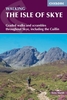
Isle Of Skye Tourist Map
The Nicolson Isle of Skye Tourist map is a 1:100, 000 scale road map suitable for touring the Isle of Skye. This map has clear, easy to read road mapping that shows all major and minor roads, tracks and paths as well as roads under construction. Also shown are railways and stations, tourist railway stations and disused railway lines, national cycle routes, and long distance footpaths. County boundaries are clearly marked, as are airports, hospitals, parking, hostels, visitor information centres, historic sites, peaks with height in meters, gardens, museums, heritage centres, viewpoints, nature reserves, picnic sites, camping grounds, caravan sites, golf courses, fishing spots and other places of interest. Natural features shown on the map include woodland areas,
national/forest parklands, mud, shingle, beaches and dunes, rocks, built up-areas and National Scottish Trust areas. The map is fully indexed.
national/forest parklands, mud, shingle, beaches and dunes, rocks, built up-areas and National Scottish Trust areas. The map is fully indexed.
Product Description
Reviews/Comments
Add New
Intelligent Comparison
Archived Product
Isle Of Man Leisure And Tourist Map Stanfords
£4.99
Vouchers
No voucher codes found.
Do you know a voucher code for this product or supplier? Add it to Insights for others to use.
Do you know a voucher code for this product or supplier? Add it to Insights for others to use.
 Denmark