More From Contributor
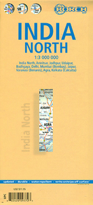
£6.99
Marco Polo India: The Travel Guide with Insider Tips Explore India with Marco Polo! This compact, straightforward guide is clearly structured for ease of use. It gets you right to the heart of this vast country, & provides you with all the latest information & lots of Insider Tips for the ultimate Asian journey.

Includes::
a road atlas & an additional pull-out map, & clear, user-friendly layout. Get your bearings with the ` Where to Start` panels & ensure you don`t miss out on the key sights using the ` Highlights` section The ` Best Of` pages feature unique aspects of the country & also suggest places to go for free, tips for things to do whatever the weather & good places to relax. Insider Tips & much more besides: Marco Polo enables you to fully experience the exotic subcontinent, from the palm-lined waterways of Kerala to the Golden Temple of Amritsar. Find out what other attractions there are apart from the world famous Taj Mahal & the sculptures of the Konark Sun Temple, plus where you can shop at the descendants of the Maharaja of Jaipur`s personal jewellers & enjoy over 600 different species of orchid. With the Marco Polo Excursions & Tours you can explore India along specific routes, & the Low Budget tips help you to save money. The author`s Insider Tips encourage you to see & experience the country in an individual & authentic way. Don`t go on holiday without a Marco Polo guide!

...
Archived Product
£6.95
This mini paperback presents a photographic compilation of modern Indian craft, design & architecture, placed in the context of Indian history & traditions. It looks at the roots & themes of Indian craft & design from village society to Moghul palaces, & shows how these traditional forms are repeated in all the contemporary arts. Herbert Ypma, together with a team of photographers, travelled across India to bring together an array of images of buildings, textiles & ceramics. Together with text, these images provide an insight into the emergence of an aesthetic that truly combines the old with the new. ...
Archived Product
£17.99
India wall map from the National Geographic Society, size 61 x 76cm (24” x 30” approx) – encapsulated version, in the NGS traditional classic style: on a light base with both internal state boundaries & international borders shown in colour. Coverage

Includes::
all of Nepal, Bhutan & Bangladesh, plus most of Tibet, eastern & northern Pakistan, Sri Lanka, etc. Disputed international borders between with Pakistan & China are marked. City names are given in their current version with the historical names in brackets; Kolkata (Calcutta), Varanasi (Banaras), Kochi (Cochin), etc. Topography is indicated by relief shading with names of various mountain ranges, peaks (heights in metres), etc. National parks are highlighted. The map shows the network of main road & rail connections & indicates locations of airports. Latitude & longitude lines are drawn at 4° intervals.* This title is also available on paper without the encapsulation.

...
Archived Product
£12.99
India wall map from the National Geographic Society, size 61 x 76cm (24” x 30” approx) – paper version, in the NGS traditional classic style: on a light base with both internal state boundaries & international borders shown in colour. Coverage

Includes::
all of Nepal, Bhutan & Bangladesh, plus most of Tibet, eastern & northern Pakistan, Sri Lanka, etc. Disputed international borders between with Pakistan & China are marked. City names are given in their current version with the historical names in brackets; Kolkata (Calcutta), Varanasi (Banaras), Kochi (Cochin), etc. Topography is indicated by relief shading with names of various mountain ranges, peaks (heights in metres), etc. National parks are highlighted. The map shows the network of main road & rail connections & indicates locations of airports. Latitude & longitude lines are drawn at 4° intervals.* This title is also available encapsulated.

...
Archived Product
£9.99
Northern & western India on a double-sided, indexed map from ITMB, providing on each side useful coverage of some of the country’s most visited areas. Each side of the map has a separate index of localities. The northern side is centred on Delhi & extends north to the Line of Control dividing Jammu & Kashmir. Coverage east along the Ganges extends beyond Varanasi; west to Jodhour, the outskirts of Ahmadabad & to Vadodara (Baroda); & south to Nagpur, the geographical centre of India. The western side of the map extends from Delhi to Bangalore & Mysore, & inland beyond Hyderabad, so

Includes::
Mumbai & Goa. The map has altitude colouring (in feet) & shows the country’s road & rail networks & local airports. Symbols highlight various places of interest including historic or scenic sites, hill stations, temples & other religious buildings, castles & forts, national parks & wildlife reserves, beaches, boating & rafting facilities, etc. Latitude & longitude lines are drawn at intervals of 2°. Each side of the map has a separate index of place names.

...
Archived Product
£9.99
Double-sided map from ITMB conveniently combining coverage of north-eastern India, including eastern Nepal, with a street plan of Kolkata (Calcutta). Indexed road map at 1:2, 300, 000 has altitude colouring (in feet) & shows the region’s road & rail networks. Symbols highlight various places of interest including historic or scenic sites, hill stations, temples & other religious buildings, castles & forts, national parks & wildlife reserves, beaches, boating & rafting facilities, etc. Latitude & longitude lines are drawn at intervals of 2°. On the reverse is a street plan of the central districts of Kolkata, showing both metro stations & tram routes with line numbers. The plan highlights various places of interest including museums, religious buildings, markets & shopping centres, foreign consulates, selected accommodation, etc. The street index

Includes::
some of the old colonial names. Also included are diagrams of the metro & tram networks & an overview map at 1:200, 000 of city’s environs showing access to the airport.PLEASE NOTE: coverage of north-eastern India is also available from ITMB combined with a road map of road map of Bangladesh at 1:750, 000m including small street plans of central Dhaka & Chittagong.

...
Archived Product
£10.99
Northern India at 1:1, 500, 000 on a waterproof & tear-resistant, double-sided map from Nelles, in a convenient size for use when travelling. An enlargement presents Ladakh & Zanskar in greater detail at 1:650, 000 & street plans of central Delhi plus Agra & Srinagar are also provided. Coverage south of Delhi extends beyond Agra & Jaipur to Jodhpur in the south-western corner & Gwalior; coverage north & west of the capital extends beyond the country’s borders to include Lahore, Rawalpindi/ Islamabad, plus the Karakoram Range with the Hunza Valley & the Karakoram Highway. The northern side of the map

Includes::
a 44x 48cm panels presenting Ladakh & Znaskar in greater detail at 1:650, 000. Also provided are three large street plans highlighting places of interest & covering central Delhi, Agra & Srinagar. Maps in the Nelles regional series of India present the country’s road & rail networks on a base with relief shading to show the topography. National parks & nature or game reserves are highlighted, as are numerous places of interest. Also shown are the country’s internal administrative boundaries with names of the states. Each map

Includes::
enlargements for most visited areas and/or street plans of main cities. Latitude & longitude are shown by margin ticks at 2°. None of the maps are indexed. Map legend

Includes::
English. To see other titles in this series please click on the series link.


...
Archived Product
£9.50
Indexed, waterproof & tear-resistant road map of North-Eastern India with topographic & tourist information, one of three regional maps of India published by Reise Know-How as part of their highly acclaimed World Mapping Project. The maps are double-sided to provide the best balance between a good scale & a convenient size sheet. The maps have altitude colouring with spot heights & names of hills & mountain ranges, plateaux, valleys, etc. Swamps, mangroves, sandy areas, glaciers, waterfalls & hot springs are indicated. Detailed road network & railways are easy to see on the base map, & local airports & airfields are marked. Nature reserves & bird sanctuaries are highlighted, & symbols show locations of various UNESCO sites, forts & palaces, temples & other religious buildings, natural curiosities, beaches, etc. The maps have a latitude & longitude grid at intervals of 1 ...
Archived Product
£9.50
Indexed, waterproof & tear-resistant road map of North-Western India with topographic & tourist information, one of three regional maps of India published by Reise Know-How as part of their highly acclaimed World Mapping Project. The maps are double-sided to provide the best balance between a good scale & a convenient size sheet. The maps have altitude colouring with spot heights & names of hills & mountain ranges, plateaux, valleys, etc. Swamps, mangroves, sandy areas, glaciers, waterfalls & hot springs are indicated. Detailed road network & railways are easy to see on the base map, & local airports & airfields are marked. Nature reserves & bird sanctuaries are highlighted, & symbols show locations of various UNESCO sites, forts & palaces, temples & other religious buildings, natural curiosities, beaches, etc. The maps have a latitude & longitude grid at intervals of 1 ...
Archived Product
£8.95
Northwestern India at 1:1, 900, 000 on an indexed map from ITMB, with the reverse side showing a street plan of Delhi with its outer suburbs, plus an enlargement of the Connaught Place central area & diagrams of the metro & rail networks. On one side is an indexed road map of north-western India centred on Delhi & extending north to the Line of Control dividing Jammu & Kashmir. Coverage east along the Ganges extends beyond Varanasi; west to Jodhour, the outskirts of Ahmadabad & to Vadodara (Baroda); & south to Nagpur, the geographical centre of India. The map has altitude colouring (in feet) & shows the country ...
Archived Product

India North Borch

Northern India, including the whole of Nepal, Bhutan and Bangladesh, at 1:3, 000, 000 on a laminated, waterproof and tear-resistant, indexed road map from Borch, with large indexed street plans of its ten main cities.Coverage extends south to Mumbai and also includes most of Pakistan and eastern Afghanistan with Kabul. Altitude colouring with relief shading shows the topography, with spot heights and names of various mountain and hill ranges, peaks and mountain passes, etc. National parks and protected areas are highlighted.Road network indicate distances and main and many secondary roads. Railway lines are included (although occasionally difficult to see against the background) and local airports are marked. Symbols highlight numerous places of interest. Also shown are internal
administrative boundaries with names of the states. The map has extensive index and has no geographical coordinates. The reverse side in taken by 10 panels with street plans at 1:30, 000 showing of central districts in Amritsar, Jodhpur, Udaipur, Bodhgaya, Delhi, Mumbai, Jaipur, Varanasi (Benares), Agra and Kolkata (Calcutta). The plans highlight main sights, selected hotels, various institutions and are indexed. The map also provides a small map of India’s administrative divisions and time zones, as well as information on the climate.Map legend and all the information include English.
RIP - This product is no longer available on our network. It was last seen on 25.09.2019

This page now acts as a permanent archive for this product. Add more information using the comments box below to ensure it can still be found by future generations.

Use our search facility to see if it is available from an alternative contributor.
  • External links may include paid for promotion
  • Availability: Out Of Stock
  • Supplier: Stanfords
  • SKU: 9783866093720
Availability: In Stock
£9.99

Product Description

Northern India, including the whole of Nepal, Bhutan & Bangladesh, at 1:3, 000, 000 on a laminated, waterproof & tear-resistant, indexed road map from Borch, with large indexed street plans of its ten main cities. Coverage extends south to Mumbai & also

Includes::
most of Pakistan & eastern Afghanistan with Kabul. Altitude colouring with relief shading shows the topography, with spot heights & names of various mountain & hill ranges, peaks & mountain passes, etc. National parks & protected areas are highlighted. Road network indicate distances & main & many secondary roads. Railway lines are included (although occasionally difficult to see against the background) & local airports are marked. Symbols highlight numerous places of interest. Also shown are internal administrative boundaries with names of the states. The map has extensive index & has no geographical coordinates. The reverse side in taken by 10 panels with street plans at 1:30, 000 showing of central districts in Amritsar, Jodhpur, Udaipur, Bodhgaya, Delhi, Mumbai, Jaipur, Varanasi (Benares), Agra & Kolkata (Calcutta). The plans highlight main sights, selected hotels, various institutions & are indexed. The map also provides a small map of India’s administrative divisions & time zones, as well as information on the climate. Map legend & all the information include English.

Reviews/Comments

Add New

Price History

Vouchers

No voucher codes found.
Do you know a voucher code for this product or supplier? Add it to Insights for others to use.

Facebook

Jargon Buster

India - A subcontinent in Asia
Waterproof - Resistant to water, usualy specified by depth in metres
Network - A link and communication between things. Often computers or people.
Large - something that takes up more space than normal.
Small - something that takes up less space than normal.
Road - a manmade lane or a path that is used to speed up travel.
Resistant - Something that can repel against something.
Altitude - Something that can be quite high in relation to sea or ground level.
Laminated - A thin layer of plastic that gives a coating and shine to a material.

Supplier Information

Stanfords
Stanfords was established in 1853 and opened their iconic Covent Garden flagship store in 1901. They have become the top retailer of maps, travel books and accessories in the UK and arguably offer the largest selection of maps and travel books worldwide. Famous names such as Captain Robert Falcon Scott, Ranulph Fiennes and Michael Palin have purchased from Stanfords. They now have a shop in Bristol and both stores together with other venues operate a calendar of events including talks, book signings and exhibitions. As a specialist map retailer, the map selection is comprehensive and includes road maps, street maps and walking maps from worldwide destinations, as well as a selection of world atlases and wall maps. Books include travel guides and travel literature. Stanfords also stock globes, from miniatures made of blue marble to magnificent floor-standing globes. The website features a selection of interesting articles on travel topics.
Page Updated: 2023-11-12 20:15:36

Community Generated Product Tags

Oh No! The productWIKI community hasn't generated any tags for this product yet!
Menu