More From Contributor

£8.50
Illinois in a series of US state maps from the National Geographic with cartography from Mapquest, including city maps of Chicago with a downtown enlargement, Springfield, Rockford, Champaign
- Urbana, Peoria, Bloomington
- Normal, & the Quad Cities, plus a scenic drive route along the Ohio River. The map is laminated & waterproof. Maps in the NGS State Series clearly show each state

...
Archived Product
£9.99
Illinois on a laminated & waterproof Easy-to-Fold map from Rand Mc Nally, the country’s leading publisher of road maps & street plans. For clarity of road information Rand Mc Nally state maps present the road network on a plain background, with no or little topographic detail. Driving distances are indicated on all principal highways & on many local routes. National or state parks & other protected areas, Indian Reservations & restricted entry military zones are highlighted & symbols indicate campsites, rest areas, various places of interest, etc. Each map shows local administrative boundaries with names of the counties, is indexed & gives geographical coordinates as margin ticks usually at 1° intervals. Rand Mc Nally state maps are available in two formats: double-sided Easy-to-Read maps with numerous enlargements for cities and/or most visited areas, & laminated Easy-to-Fold maps in a more handy format but with smaller print. TO SEE THE LIST OF RAND Mc NALLY STATE MAPS PLEASE CLICK ON THE SERIES LINK. ...
Archived Product
£6.99
Illinois Easy-to-Read map from Rand Mc Nally, US leading publisher of road maps & street plans, in their extensive series of state maps. Additional panels provide enlargements for Bloomington
- Normal, Champaign
- Urbana, Chicago & vicinity, downtown Chicago, Decatur, Peoria, Quad Cities (Bettenforf & Davenport, IA, plus Miline & Rock Island), Rockford, St. Louis
- Metro East & Springfield. For clarity of road information Rand Mc Nally state maps present the road network on a plain background, with no or little topographic detail. Driving distances are indicated on all principal highways & on many local routes. National or state parks & other protected areas, Indian Reservations & restricted entry military zones are highlighted & symbols indicate campsites, rest areas, various places of interest, etc. Each map shows local administrative boundaries with names of the counties, is indexed & gives geographical coordinates as margin ticks usually at 1° intervals. Rand Mc Nally state maps are available in two formats: double-sided Easy-to-Read maps with numerous enlargements for cities and/or most visited areas, & laminated Easy-to-Fold maps in a more handy format but with smaller print. TO SEE THE LIST OF RAND Mc NALLY STATE MAPS PLEASE CLICK ON THE SERIES LINK.


...
Archived Product
£19.99
Illinois Recreational Atlas & Gazetteer at 1:150, 000 approx. in a series of large format paperback state atlases from De Lorme, with detailed, contoured, GPS compatible topographic mapping. Recreational information

Includes::
lists of canoe trips, fishing hot spots, trails for hiking/mountain biking/horse riding/cross-country skiing, wildlife sites, unique natural features, historic sites, museums, & scenic drives. Tables are also provided showing park/forests/recreation areas, plus fishing & hunting sites each with a list of species. Each title in this De Lorme series covers one state & presents it at a scale much more detailed than used on most state road maps. Particularly popular areas are often also presented on enlargements. The maps are contoured, show variation of terrain (deserts, glaciers, wetlands, woodlands, etc) & have latitude & longitude and/or UTM grid lines for GPS use. Various types of protected areas are distinguished by the colouring of their boundaries, e.g. national or state parks, forests, etc. Also marked are Indian Reservations & restricted entry military zones. Road network is shown in much more detail than on other state mapping, with local roads, unsurfaced back roads & tracks, forest trails, etc. Where appropriate, old historical routes are marked. Railway lines & local airports or landing strips are included & the maps also indicate administrative boundaries. Symbols highlight various recreational areas & facilities such as campgrounds, unique natural features, etc. Each title contains extensive lists of outdoor adventure sites (grouped into activities such as hiking, biking, paddling, fishing, skiing, etc.), diverse family outing sites, campgrounds, & tables showing what facilities can be found in the state’s recreational areas. Each atlas also has an index of localities. To see the list of titles in this series please click on the series link.

...
Archived Product
£6.95
Topographic coverage of mainland Spain at 1:50, 000 in the MTN50 (Mapa Topográfico Nacional) series from the Centro Nacional de Información Geografica, the country’s civilian survey organization. The maps have contours at 20m intervals, enhanced by relief shading, plus colouring and/or graphics to show different types of terrain, vegetation or land use. Boundaries of national parks & other protected areas are marked. In addition to all the usual information featured on topographic mapping at this scale, detailed presentation of the road & rail networks, rural tracks & paths, etc, the maps also show campsites & mountain refuges. On more recent editions some GRs, the official long-distance hiking routes, are also marked (although not as clearly as on hiking maps from other publishers). Each map covers 29.5x 18.5 km (with adjustments in the border or coastal areas). The maps have a 1-km UTM grid, plus margin ticks for latitude & longitude at 1` intervals. Map legend is in Spanish only.HOW TO CHOOSE THE RIGHT 50K MAP: all the titles in CNIG’s 200K Provincial Road Maps series at 1:200, 000 are overprinted with the grid for the 1:50, 000 maps & can be used to see the area covered by each 50K title. TO SEE THE LIST OF TITLES IN THIS SERIES PLEASE CLICK ON THE SERIES LINK.PLEASE NOTE
- MAP TITLES: the grids shown on our website serve both the civilian & the military 1:50, 000 topographic series. Although the areas covered by maps in both series are identical (apart from some border or coastal sheets), occasionally map titles differ – only one title is shown on the grid, usually the military one. In Galicia, the Basque country & in the Catalan speaking areas the tendency now is to use local place names rather than the often better known Castilian ones. Where possible, both versions are included in our titles. Map titles listed on our website are based on information received by us at the time of publication, but sometimes maps arrive showing a completely different title! As long as the map number is as ordered, the correct map has been supplied.
...
Archived Product
£20.00
An anatomy lesson like no other! Look inside the human body with the magic three-colour lens & x-ray from head to toe to discover how your body works. Use the red lens to reveal the skeleton, the green to see the muscles working, & x-ray your organs with the blue lens to find out what they do day & night to keep you alive. Uncover the secrets of the human body & explore how its different systems work in this stunning follow up to the internationally best-selling Illuminature. Jam-packed with detailed illustrations & full of facts & information, this innovative encyclopedia from from Milan-based design duo Carnovsky will make you see the human body in a whole new light. ...
Archived Product
£35.00
Bring the moon into your own room. The authentic moonscape shines moonlight just like the real moon & makes a stunning ...
Archived Product
£45.00
With this incredible 85 cm diameter Solar System Mobile you can explore the wonders of the universe from the comfort of your own bedroom! This Remote Controlled, motorised mobile has nine planets that actually orbit the sun; the sun also lights up & casts its glow on the detailed coloured planets. Take a tour of our solar system with a little booklet featuring fascinating facts & colour pictures about each planet. The remote control also doubles up as a light pointer, which you can use to locate each planet & to make comets & meteors streak through the night sky. Each mobile kit

Includes::
nine full colour detailed planets, remote control with built-in light pointer & comet maker. The mobile can be fitted very simply to a ceiling using the enclosed hardware, & as it is battery operated so there is no need to worry about connecting to the mains! This is a fantastic educational addition to any room which doubles as a beautiful soft night light. Please note this product is battery operated 3x AA plus 2x AAA, not included.

...
Archived Product
£12.99
A powerful story of revolution, love & intense rivalry set in 1870 during the four-month siege of Paris. 1870. All over Paris the lights are going out. The Prussians are encircling the city & Europe's capital of decadent pleasure & luxury is becoming a prison, its citizens caught between defiance & despair. Desperate times lie ahead as the worst winter for decades sets in & starvation looms. One man seems to shine like a beacon in the shadows. Jean-Jacques Allix promises to be the leader the people need, to save the city itself. Painter Hannah Pardy, his young English lover, believes in him utterly; taking up arms for his cause, she is drawn into the heart of the battle for Paris. But as the darkness & panic spreads it is harder & harder to see things as they really are, & Hannah struggles to separate love from self-interest & revolutionaries from traitors. Faced with impossible decisions, Hannah must confront the devastating reality of her beloved Paris to establish what truly matters to her
- & what she will do to protect it.
...
Archived Product

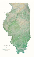
Illinois State Physical Wall Map

Detailed physical wall map of Illinois State at a scale of 1:500, 000. The cartography shows relief through a stunning, highly detailed shading, with different elevations varing in colouring, giving an almost 3-dimensional feel to the map. Peak heights are also clearly marked.The map displays land only within the boundaries of the chosen states - there is no overlap with neigbouring states. Principal physical features such as glaciers, mountain ranges, rivers and lakes are shown clearly. Human features, such as main towns, cities, roads and railways, are shown in a very fine, subtle and elegant cartographic style. State capitals are also clearly marked.This map measures 84x140cm (33”x55”). Our Illinois map beautifully displays the delicate landscape. From Lake Michigan to the
Ohio and Mississippi Rivers, the valleys, plains, rivers, and prairies are exquisitely mapped in shades of greens and light browns.*About this series:*Located on the corner of Main and Central in downtown Medford, Oregon since 1986, Raven has become the quintessential small company with a big reputation. Every map is created with attention to accuracy and elegance, from gathering the base information to the final color adjustment on the printing press.
RIP - This product is no longer available on our network. It was last seen on 25.09.2019

This page now acts as a permanent archive for this product. Add more information using the comments box below to ensure it can still be found by future generations.

Use our search facility to see if it is available from an alternative contributor.
  • External links may include paid for promotion
  • Availability: Out Of Stock
  • Supplier: Stanfords
  • SKU: 9780783425573
Availability: In Stock
£30.00

Product Description

Detailed physical wall map of Illinois State at a scale of 1:500, 000. The cartography shows relief through a stunning, highly detailed shading, with different elevations varing in colouring, giving an almost 3-dimensional feel to the map. Peak heights are also clearly marked. The map displays land only within the boundaries of the chosen states
- there is no overlap with neigbouring states. Principal physical features such as glaciers, mountain ranges, rivers & lakes are shown clearly. Human features, such as main towns, cities, roads & railways, are shown in a very fine, subtle & elegant cartographic style. State capitals are also clearly marked. This map measures 84x 140cm (33”x 55”). Our Illinois map beautifully displays the delicate landscape. From Lake Michigan to the Ohio & Mississippi Rivers, the valleys, plains, rivers, & prairies are exquisitely mapped in shades of greens & light browns.* About this series:* Located on the corner of Main & Central in downtown Medford, Oregon since 1986, Raven has become the quintessential small company with a big reputation. Every map is created with attention to accuracy & elegance, from gathering the base information to the final color adjustment on the printing press.

Reviews/Comments

Add New

Price History

Vouchers

No voucher codes found.
Do you know a voucher code for this product or supplier? Add it to Insights for others to use.

Facebook

Jargon Buster

Physical - Used to describe strength or visual properties of an item
Wall - A physical barrier between two areas
Human - A highly developed and adapted mamal and deminant species on earth
Railways - A set of tracks that have been laid for the purpose of trains to travel up and down them
Small - something that takes up less space than normal.
Subtle - Something that is delicate and not to harsh, can be difficult to describe.

Supplier Information

Stanfords
Stanfords was established in 1853 and opened their iconic Covent Garden flagship store in 1901. They have become the top retailer of maps, travel books and accessories in the UK and arguably offer the largest selection of maps and travel books worldwide. Famous names such as Captain Robert Falcon Scott, Ranulph Fiennes and Michael Palin have purchased from Stanfords. They now have a shop in Bristol and both stores together with other venues operate a calendar of events including talks, book signings and exhibitions. As a specialist map retailer, the map selection is comprehensive and includes road maps, street maps and walking maps from worldwide destinations, as well as a selection of world atlases and wall maps. Books include travel guides and travel literature. Stanfords also stock globes, from miniatures made of blue marble to magnificent floor-standing globes. The website features a selection of interesting articles on travel topics.
Page Updated: 2023-11-12 20:15:36

Community Generated Product Tags

Oh No! The productWIKI community hasn't generated any tags for this product yet!
Menu