
 United Kingdom
 France
 Germany
 Netherlands
 Sweden
 USA
USA
 Italy
Italy
 Spain
Spain
More From Contributor


Hong Kong
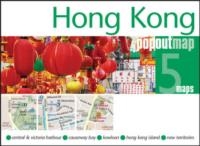
This clear map shows both the road network and public transport system for the city centre over Kowloon Peninsula and Hong Kong Island.Coverage extends from Sham Shui Po district in the north to the Victoria Peak and Happy Valley in the south. And from Shek Tong Tsui district in the west (including the University of Hong Kong) to Kwun Tong district and Quarry Bay in the east.Ferry services within the city and railway, subway and bus stations are indicated, as well as district names. A series of symbols marks police stations, hospitals, leisure and public facilities, points of interest and notable buildings.An inset map shows the main road and suburban rail networks into the area surrounding the city, and the ferry services between the various islands.Includes a map of the railway and
underground system and an index.
underground system and an index.
Product Description
Reviews/Comments
Add New
Intelligent Comparison
Archived Product
Hong Kong Stanfords
£4.99
Archived Product
Hong Kong Stanfords
£8.50
Archived Product
Hong Kong Stanfords
£4.99
Archived Product
Hong Kong Stanfords
£7.95
Archived Product

Hong Kong Stanfords
£17.50
Archived Product

Top 10 Hong Kong Stanfords
£8.99
Archived Product
Pop-up Hong Kong Stanfords
£5.00
Archived Product
Hong Kong PopOut Stanfords
£3.99
Vouchers
No voucher codes found.
Do you know a voucher code for this product or supplier? Add it to Insights for others to use.
Do you know a voucher code for this product or supplier? Add it to Insights for others to use.
 Denmark