
 United Kingdom
 France
 Germany
 Netherlands
 Sweden
 USA
USA
 Italy
Italy
 Spain
Spain
More From Contributor

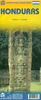


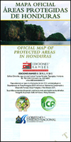
Honduras Protected Areas Map
Protected areas of Honduras on a map at 1:838, 000 published by Ramses Ediciones in cooperation with the country’s National Institute of Forest Conservation and Development, Protected Areas and Wildlife (ICF) - Department of Protected Areas and Wildlife (DAP), with detailed classification into 15 categories and a list of the 91 protected areas.On one side is a map of Honduras showing the division of the country into provinces with 15 different colour bands highlighting protected areas from forest or biosphere reserves to marine parks and water producing regions. Topography is shown by relief shading with names of mountain ranges and spot height; numerous rives are named. Symbols highlight locations of natural or cultural monuments, archaeological remains and waterfalls. Each province
is shown with its administrative capital but without the connecting road network. Map legend includes English.The reverse side provides a list of the 91 officially protected areas with full classification and details such as size, location on the main map, the type of flora and/or fauna, etc. Also provided are official descriptions for each category of protection. The text is in Spanish only.
is shown with its administrative capital but without the connecting road network. Map legend includes English.The reverse side provides a list of the 91 officially protected areas with full classification and details such as size, location on the main map, the type of flora and/or fauna, etc. Also provided are official descriptions for each category of protection. The text is in Spanish only.

Product Description
Reviews/Comments
Add New
Vouchers
No voucher codes found.
Do you know a voucher code for this product or supplier? Add it to Insights for others to use.
Do you know a voucher code for this product or supplier? Add it to Insights for others to use.
 Denmark