
 United Kingdom
 France
 Germany
 Netherlands
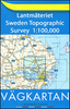
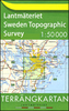
 Sweden
 USA
USA
 Italy
Italy
 Spain
Spain
More From Contributor

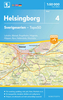


Helsinki
Helsinki street plan at 1:15, 000 from Falk showing bus and tram routes with stops and line numbers. Place names are given in both Finnish and Swedish, with a dual index, plus contact details for various services and places of interest.The plan shows metro stations, has tram and bus lines annotated with stops and line numbers, and clearly indicates various ferry terminals and routes from them. For drivers principal traffic arteries are highlighted; one way streets and car parks are marked. A range of symbols indicates locations of various facilities. Multilingual map legend includes English.The index is on the reverse and has separate lists for the Finnish and the Swedish place names, plus lists of various services and places of interest with contact details. Also provided is a small
road map of the city
road map of the city
Product Description
Reviews/Comments
Add New
Intelligent Comparison
Archived Product

Helsinki Stanfords
£17.99
Archived Product

Helsinki F&B Stanfords
£9.99
Archived Product

Helsinki Noir Stanfords
£11.99
Archived Product
Hesdin Stanfords
£11.50
Vouchers
No voucher codes found.
Do you know a voucher code for this product or supplier? Add it to Insights for others to use.
Do you know a voucher code for this product or supplier? Add it to Insights for others to use.
 Denmark