More From Contributor
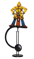
£8.99
Paper version of map No. 17 from the Ordnance Survey’s Landranger series at 1:50, 000, with contoured & GPS compatible topographic mapping plus tourist information.MOBILE DOWNLOADS: As well as the physical edition of the map, each Landranger title now

Includes::
a code for downloading after purchase its digital version onto your smartphone or tablet for viewing on the OS smartphone app.OS LANDRANGER SERIES: to see the list of all the titles in the OS Landranger series, both paper & waterproof versions, please click on the series link. Maps in the Landranger series provide plenty of recreational & tourist information, indicating the traditional public right of way paths (except in Scotland where different laws apply), including bridleways & byways restricted or open to motorized traffic. National Trails & selected other long-distance paths are marked, as well as on-road & traffic-free cycle routes with their National/ Regional Cycle Network numbers. National Trust/ National Trust for Scotland & Forestry Commission land is clearly marked, indicating open or restricted access. A range of symbols highlights camping & caravanning sites, youth hostels, tourist information offices & visitors’ centres, parking & picnicking places, World Heritage sites, sport & recreational facilities, etc. The maps provide detailed presentation of topography with contours at 10m intervals, numerous spot heights & additional colouring and/or graphics for different types of woodlands, orchards or parkl&, rock features including scree & cliffs, water features inland & along the sea shore with marshl&, dunes, s&, mud, shingle & the high water mark. All the standard information expected of survey mapping at this scale is included: finely graded road network, railway lines with stations, cuttings, embankments, etc; individual isolated buildings; archaeological & historical sites, etc. For GPS users the British National Grid is shown at 1km intervals, with latitude & longitude given by margin ticks at 1` & cross hairs on the map at 5`. Each map covers an area of 40 x 40km, (approx. 25 x 25 miles).

...
Archived Product
£5.59
Map No. 17, Helmsdale & Strath of Kildonan or Strath Ullie, in the Ordnance Survey Landranger series at 1:50, 000, including Brora, Lothmore, Portgower, Balnacoil, Kilphedir, Berriedale, Ramscraigs, Dunbeath, Braemore, Houstry, & Kinbrace, with Cnoc Garbh-leathaid, Cnoc na Fe ...
Archived Product
£9.09
Map No. 17, Helmsdale & Strath of Kildonan or Strath Ullie, in the waterproof & tear-resistant OS Active version of the Ordnance Survey Landranger series at 1:50, 000, including Brora, Lothmore, Portgower, Balnacoil, Kilphedir, Berriedale, Ramscraigs, Dunbeath, Braemore, Houstry, & Kinbrace, with Cnoc Garbh-leathaid, Cnoc na Fe ...
Archived Product
£10.39
Map No. 17, Helmsdale & Strath of Kildonan or Strath Ullie, in a waterproof & tear-resistant version of the Ordnance Survey Landranger series at 1:50, 000, including Brora, Lothmore, Portgower, Balnacoil, Kilphedir, Berriedale, Ramscraigs, Dunbeath, Braemore, Houstry, & Kinbrace, with Cnoc Garbh-leathaid, Cnoc na Fe ...
Archived Product
£3.50
Helmsley in 1910 in a fascinating series of reproductions of old Ordnance Survey plans in the Alan Godfrey Editions, ideal for anyone interested in the history of their neighbourhood or family. Selected towns in Great Britain & Ireland are covered by maps showing the The map is double-sided; the main map covers the southern part of the town, from the Market Place southward to Low Woods Farm, &

Includes::
the Castle, the eastern face of Duncombe Park house, railway with station, River Rye, Helmsley Bridge, Bridge Street, Ryegate, Pottergate, etc. On the reverse is part of the adjacent sheet 89.07 which continues coverage north, including Bondgate, Court House, Market Place, Workhouse, All Saints church, Canons Garth & High Street. About the Alan Godfrey Editions of the 25” OS Series: Selected towns in Great Britain & Ireland are covered by maps showing the extent of urban development in the last decades of the 19th & early 20th century. The plans have been taken from the Ordnance Survey mapping & reprinted at about 15 inches to one mile (1:4, 340). On the reverse most maps have historical notes & many also include extracts from contemporary directories. Most maps cover about one mile (1.6kms) north/south, one & a half miles (2.4kms) across; adjoining sheets can be combined to provide wider coverage.FOR MORE INFORMATION & A COMPLETE LIST OF ALL AVAILABLE TITLES PLEASE CLICK ON THE SERIES LINK.

...
Archived Product
£12.99
` It`s scary telling the truth in a book. In stand up you can say anything as long as it`s funny, but in a book you can say anything.` Simon Amstell`s deeply personal comedy has been described as `part Samuel Beckett, part self-help manual` & `funny`. In his first book, Amstell looks at the recurring themes of his standup & tries to figure out who he is before he dies. ...
Archived Product
£9.99
Yes I Can! Help Save Our Planet by Emma Brownjohn is a book for small children that offers suggestions for making our planet a healthier & better place to live, presented in a fun lift-the-flap format. The book

Includes::
information on recycling, solar heating, organic gardening & lots more. The Green Game at the end of the book helps to reinforce this message.

...
Archived Product
£9.99
Yes I Can! Help Save the Animals by Emma Brownjohn is a book for small children, which deals with the important issue of endangered animals. It aims to make them aware of the dangers facing our animals in different habitats
- global warming, over-fishing, chopping down the forests etc
- so they & their parents can make choices for the future.

...
Archived Product
£12.99
Inspired by our native landscapes, saturated by the shadows beneath trees & behind doors, listening to the run of water & half-heard voices, Tom Cox s first collection of short stories is a series of evocative & unsettling trips into worlds previously visited by the likes of M. R. James & E. F. Benson. Railway tunnels, the lanes & hills of the Peak District, family homes, old stones, shreds fluttering on barbed wire, night drawing in, something that might be an animal shifting on the other side of a hedge: Tom has drawn on his life-long love of weird fiction, folklore & nature s unregarded corners to write a collection of stories that will delight fans old & new, & leave them very uneasy about turning the reading lamp off. ...
Archived Product
£12.99
From one of the most acclaimed & dynamic picture book makers of his time comes a book that tests the very meaning of a picture book story, plays havoc with formal type & design & speaks directly to its readers! This is a new picture book from Herve Tullet! How exciting. Open it up
- see what`s inside! Hello! There`s lots of characters. & they`re looking right at YOU. They seem to be a bit surprised... Hmmm, maybe they`re not quite ready? (The drawing`s a bit messy, too. It looks like this illustrator has some more work to do.) Let`s read on & see. Uh-oh
- it seems the characters don`t actually know what to DO! Hang on...there`s not even a STORY because
- guess what?!
- this book isn`t FINISHED! But while you`re here (and because you probably DO want a story, right?) they`re going to try & find one for you. & they might just need the help of a certain author... Tullet takes the concept of reading to a new level & encourages young children to interact with the book form, teaching them, in the process, to think imaginatively, independently & creatively. This is a book full of funny, original ideas: a story within a story complete with photos of Herve Tullet himself talking to the characters. Un livre won the Sorcieres prize in 2010, & was a worldwide bestseller, published in 27 languages.


...
Archived Product

Helmsman

Skyhooks, effortless counter-weighted art that could be set on a shelf or the rim of a table, and set in motion to everybody’s delight and amazement. The Helmsman sky hook features a yellow raincoat-clad boat captain at the helm of vessel. Hand-crafted from recycled metal and hand-painted. When gently pushed, the sky hook will rock back and forth on its metal stand, causing the captain move to steer his boat.If we do not have this item in stock we will order it for you from our supplier. Delivery generally takes 3 weeks within the UK. For overseas delivery queries please email sales@stanfords.co.uk
RIP - This product is no longer available on our network. It was last seen on 25.09.2019

This page now acts as a permanent archive for this product. Add more information using the comments box below to ensure it can still be found by future generations.

Use our search facility to see if it is available from an alternative contributor.
  • Availability: Out Of Stock
  • Supplier: Stanfords
  • SKU: 0781934309802
Availability: In Stock
£110.00

Product Description

Skyhooks, effortless counter-weighted art that could be set on a shelf or the rim of a table, & set in motion to everybody’s delight & amazement. The Helmsman sky hook features a yellow raincoat-clad boat captain at the helm of vessel. H&-crafted from recycled metal & h&-painted. When gently pushed, the sky hook will rock back & forth on its metal st&, causing the captain move to steer his boat. If we do not have this item in stock we will order it for you from our supplier. Delivery generally takes 3 weeks within the UK. For overseas delivery queries please email sales@stanfords.co.uk

Reviews/Comments

Add New

Intelligent Comparison

Oooops!
We couldn't find anything!
Perhaps this product's unique.... Or perhaps we are still looking for comparisons!
Click to bump this page and we'll hurry up.

Price History

Vouchers

No voucher codes found.
Do you know a voucher code for this product or supplier? Add it to Insights for others to use.

Facebook

Jargon Buster

Recycled - A term used to describe something which has been made from a reprocessed material
UK - United Kingdom - An island nation in Europe
Hand - A part of the body at the end of the arm
Hand - A pointer which indicates time on a clock face
Yellow - A primary colour. The sun is often described as yellow
email - An electronic communication method. Short for Electronic Mail.
delivery - The method by which something is delivered from one location to another
Set - a group of items usually related to one another. Some objects cannot function without the complete set of items.

Supplier Information

Stanfords
Stanfords was established in 1853 and opened their iconic Covent Garden flagship store in 1901. They have become the top retailer of maps, travel books and accessories in the UK and arguably offer the largest selection of maps and travel books worldwide. Famous names such as Captain Robert Falcon Scott, Ranulph Fiennes and Michael Palin have purchased from Stanfords. They now have a shop in Bristol and both stores together with other venues operate a calendar of events including talks, book signings and exhibitions. As a specialist map retailer, the map selection is comprehensive and includes road maps, street maps and walking maps from worldwide destinations, as well as a selection of world atlases and wall maps. Books include travel guides and travel literature. Stanfords also stock globes, from miniatures made of blue marble to magnificent floor-standing globes. The website features a selection of interesting articles on travel topics.
Page Updated: 2023-11-12 20:15:36

Community Generated Product Tags

Oh No! The productWIKI community hasn't generated any tags for this product yet!
Menu