More From Contributor
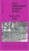
£3.50
Hayes End in 1894 in a fascinating series of reproductions of old Ordnance Survey plans in the Alan Godfrey Editions, ideal for anyone interested in the history of their neighbourhood or family. The map covers the hamlet of Hayesend (or Hayes End), extending southward to Woodend Green. A largely rural map, features include Hayesend Farm, Hayes Park (a private lunatic asylum), Westcombe Lodge etc. An 1890 directory of Hayes is on the reverse. About the Alan Godfrey Editions of the 25” OS Series: Selected towns in Great Britain & Ireland are covered by maps showing the extent of urban development in the last decades of the 19th & early 20th century. The plans have been taken from the Ordnance Survey mapping & reprinted at about 15 inches to one mile (1:4, 340). On the reverse most maps have historical notes & many also include extracts from contemporary directories. Most maps cover about one mile (1.6kms) north/south, one & a half miles (2.4kms) across; adjoining sheets can be combined to provide wider coverage.FOR MORE INFORMATION & A COMPLETE LIST OF ALL AVAILABLE TITLES PLEASE CLICK ON THE SERIES LINK. ...
Archived Product
£15.95
The quiet farming community of Hayes was precipitated into the industrial age by the construction of the Grand Union Canal, the importance of the Great West Road & the vast extension of Heathrow. Companies such as EMI & Fairey Aviation settled here & for many years, the working population overwhelmed the facilities of the little village. ...
Archived Product
£3.50
Hayes South in 1935 in a fascinating series of reproductions of old Ordnance Survey plans in the Alan Godfrey Editions, ideal for anyone interested in the history of their neighbourhood or family. The map covers what until the end of the 18th century this was a completely rural area, but the development of brickmaking & then the arrival of the railway stimulated growth. But the real turning point came in 1899 when the Hayes Development Co acquired land near the railway & laid out roads for industry. This title shows the result, with numerous factories close to Hayes & Harlington station & the Grand Junction Canal. These include the Hayes Cocoa Co, taken over by Nestle in 1929, & the Gramophone Co (soon part of EMI). Factories are also shown for potato crisps, postage stamps, chairs & cheese. Elsewhere on the map development continues to the south, the start of the Paddington Branch canal is shown, & there are still some orchards or market gardens. The population of Hayes UD rose from 2, 594 in 1901 to about 31, 000 by 1935 & this busy map, with its comprehensive introduction by John Griffiths, helps show why. About the Alan Godfrey Editions of the 25” OS Series: Selected towns in Great Britain & Ireland are covered by maps showing the extent of urban development in the last decades of the 19th & early 20th century. The plans have been taken from the Ordnance Survey mapping & reprinted at about 15 inches to one mile (1:4, 340). On the reverse most maps have historical notes & many also include extracts from contemporary directories. Most maps cover about one mile (1.6kms) north/south, one & a half miles (2.4kms) across; adjoining sheets can be combined to provide wider coverage.FOR MORE INFORMATION & A COMPLETE LIST OF ALL AVAILABLE TITLES PLEASE CLICK ON THE SERIES LINK. ...
Archived Product
£3.50
Hayfield in 1919 in a fascinating series of reproductions of old Ordnance Survey plans in the Alan Godfrey Editions, ideal for anyone interested in the history of their neighbourhood or family. The map covers the north Derbyshire village of Hayfield, with some rural coverage southward to Ollersett. Features include railway with station, Hayfield village, Print Works, Birch Quarry, Swallowhouse Mills, St Matthew`s church, Jumble, Rockhall, Kinder Row, Bowden Bridge, etc. On the reverse are directories for Hayfield in 1904 & 1916, together with a timetable for the Hayfield branch in 1922 About the Alan Godfrey Editions of the 25” OS Series: Selected towns in Great Britain & Ireland are covered by maps showing the extent of urban development in the last decades of the 19th & early 20th century. The plans have been taken from the Ordnance Survey mapping & reprinted at about 15 inches to one mile (1:4, 340). On the reverse most maps have historical notes & many also include extracts from contemporary directories. Most maps cover about one mile (1.6kms) north/south, one & a half miles (2.4kms) across; adjoining sheets can be combined to provide wider coverage.FOR MORE INFORMATION & A COMPLETE LIST OF ALL AVAILABLE TITLES PLEASE CLICK ON THE SERIES LINK. ...
Archived Product
£3.50
Hayle & Lelant in 1876 in a fascinating series of reproductions of old Ordnance Survey plans in the Alan Godfrey Editions, ideal for anyone interested in the history of their neighbourhood or family. The map is taken from the 1st Edition of the OS 25” map & shows much of the small town of Hayle in 1876 (but apparently with railway information to 1877). Features include the harbour, railway & station, Steam Packet Hotel, Custom House, iron foundry. The map extends east to Mount Pleasant. The River Hayle runs north-south through the centre & on the west bank is the village of Uny Lelant, including railway, Griggs & St Unys church. A directory of Hayle in 1910 is included on the reverse. About the Alan Godfrey Editions of the 25” OS Series Selected towns in Great Britain & Ireland are covered by maps showing the extent of urban development in the last decades of the 19th & early 20th century. The plans have been taken from the Ordnance Survey mapping & reprinted at about 15 inches to one mile (1:4, 340). On the reverse most maps have historical notes & many also include extracts from contemporary directories. Most maps cover about one mile (1.6kms) north/south, one & a half miles (2.4kms) across; adjoining sheets can be combined to provide wider coverage.FOR MORE INFORMATION & A COMPLETE LIST OF ALL AVAILABLE TITLES PLEASE CLICK ON THE SERIES LINK. ...
Archived Product
£11.50
Topographic survey of France at 1:25, 000 in IGN`s excellent TOP25 / Série Bleue series. All the maps are GPS compatible, with a 1km UTM grid plus latitude & longitude lines at 5’ intervals. Contours are at 5m intervals except for mountainous areas where the maps have contours at 10m intervals, vividly enhanced by hill shading & graphics for rocky terrain. Colouring with graphics indicates different types of vegetation or land use (deciduous or coniferous forests, moors, orchards, vineyards, etc). PLEASE NOTE: coverage of France at this scale is currently being revised – the format & the presentation of each title are indicated by the letters at the end of its Sheet Reference number (e.g. 0416ET, 3531ETR, 1923SB, etc.)MAPS WITH FULL TOURIST OVERPRINT & AN ENGLISH MAP LEGEND: all TOP25 maps & the SB editions of Série Bleue have an overprint highlighting waymarked walking trails including long-distance GR routes &, where appropriate, ski routes. Symbols indicate campsites, gîtes d’etape, refuges, equestrian centres & other recreational facilities or sites, tourist information centres, cultural heritage, etc. Towns & locations of particular interest are highlighted.- ET or OT = single-sided TOP25 map covering approx. 29x 21 km / 18x 13 miles.- ETR or OTR = waterproof & tear resistant TOP25 map covering the same area as the corresponding ET or OT number, but double-sided, printed on a smaller size sheet with a good overlap between the sides.- SB = Série Bleue map with full tourist overprint; these maps, first introduced in summer 2014, each cover approx. 29x 24km / 18x 15 miles.SÉRIE BLEUE maps with numbers ending in E (Est) or O (Ouest): most editions now indicate the GR routes, but do not show any other tourist information. Map legend is in French only. Each map covers approx. 14x 20km / 9x 12 miles. ...
Archived Product
£2.95
Stockport Offerton & Foggbrook in 1907 in a fascinating series of reproductions of old Ordnance Survey plans in the Alan Godfrey Editions, ideal for anyone interested in the history of their neighbourhood or family. Selected towns in Great Britain & Ireland are covered by maps showing the extent of urban development in the last decades of the 19th & early 20th century. In this title: the map covers an area south-eastern of Stockport that was still semi-rural. Coverage stretches from Maitland Street eastward to Foggbrook, & from Banks Lane southward to Cherrytree Lane. Features include Stockport Great Moor area, Offerton Fold, Mile End Hall, Hampstead Cotton Mills, Isolation Hospital, Hollymount Lodge, Dialstone Lane Farm, Girls Industrial School, Offerton Industrial School, Gildedhollies, St John's church, Offerton Hall, Foggbrook Print Works, etc. On the reverse is an 1896 directory of Offerton. About the Alan Godfrey Editions of the 25 ...
Archived Product
£3.50
Stockport Offerton & Foggbrook in 1907 in a fascinating series of reproductions of old Ordnance Survey plans in the Alan Godfrey Editions, ideal for anyone interested in the history of their neighbourhood or family. The map covers an area south-eastern of Stockport that was still semi-rural. Coverage stretches from Maitland Street eastward to Foggbrook, & from Banks Lane southward to Cherrytree Lane. Features include Stockport Great Moor area, Offerton Fold, Mile End Hall, Hampstead Cotton Mills, Isolation Hospital, Hollymount Lodge, Dialstone Lane Farm, Girls Industrial School, Offerton Industrial School, Gildedhollies, St John`s church, Offerton Hall, Foggbrook Print Works, etc. On the reverse is an 1896 directory of Offerton. About the Alan Godfrey Editions of the 25” OS Series: Selected towns in Great Britain & Ireland are covered by maps showing the extent of urban development in the last decades of the 19th & early 20th century. The plans have been taken from the Ordnance Survey mapping & reprinted at about 15 inches to one mile (1:4, 340). On the reverse most maps have historical notes & many also include extracts from contemporary directories. Most maps cover about one mile (1.6kms) north/south, one & a half miles (2.4kms) across; adjoining sheets can be combined to provide wider coverage.FOR MORE INFORMATION & A COMPLETE LIST OF ALL AVAILABLE TITLES PLEASE CLICK ON THE SERIES LINK. ...
Archived Product
£36.95
Military topographic survey mapping with contours. These maps are designed primarily as flying charts for aircraft, but they are useful as general topographical maps where nothing else is available. Contours are shown in feet, with elevation colouring & spot heights. Towns, villages, major roads, railways & airports are shown (but please note that many of the smaller settlements are not named, & the road information is not necessarily up to date). Some air navigation information also appears on the map, such as radio beacons & restricted flying zones. Double-sided sheet. ...
Archived Product
£35.00
Five handy booklets written & compiled by Phil Cregeen, a seasoned cruising yachtsman. They offer notes & guidance based upon the author`s experiences & observations during the last few years whilst cruising the islands in his 36ft steel sloop. Include many h&-drawn maps covering the popular & less-popular beaches, coves, bays & anchorages. Titles include Fiji, the Ha`apai Group in Tonga, Vanuatu, Southern New Caledonia, & Micronesia. ...
Archived Product

Haywards Heath 1896

Haywards Heath in 1896 in a fascinating series of reproductions of old Ordnance Survey plans in the Alan Godfrey Editions, ideal for anyone interested in the history of their neighbourhood or family. The map covers the area around and to the west of the station, stretching from Hazelgrove Road westward to Stafford House and Broad Street, and from Paige`s Wood southward to Great Haywards Wood. This was a select area, as is shown by the many large houses in extensive gardens, with the Cattle Market by the station the only `urban` feature. Other features include St Wilfrid`s church, Paddockhall Road, Muster Green, Holy Cross Home orphanage, Bolnore, Butler`s Green, Burnthouse Farm, Hatchgate Farm. A small portion of Cuckfield around the Wheat Sheaf Inn is in the top left corner.
There are extracts from a contemporary directory on the reverse.About the Alan Godfrey Editions of the 25” OS SeriesSelected towns in Great Britain and Ireland are covered by maps showing the extent of urban development in the last decades of the 19th and early 20th century. The plans have been taken from the Ordnance Survey mapping and reprinted at about 15 inches to one mile (1:4, 340). On the reverse most maps have historical notes and many also include extracts from contemporary directories. Most maps cover about one mile (1.6kms) north/south, one and a half miles (2.4kms) across; adjoining sheets can be combined to provide wider coverage.FOR MORE INFORMATION AND A COMPLETE LIST OF ALL AVAILABLE TITLES PLEASE CLICK ON THE SERIES LINK.
RIP - This product is no longer available on our network. It was last seen on 25.09.2019

This page now acts as a permanent archive for this product. Add more information using the comments box below to ensure it can still be found by future generations.

Use our search facility to see if it is available from an alternative contributor.
  • External links may include paid for promotion
  • Availability: Out Of Stock
  • Supplier: Stanfords
  • SKU: 9780850547436
Availability: In Stock
£3.50

Product Description

Haywards Heath in 1896 in a fascinating series of reproductions of old Ordnance Survey plans in the Alan Godfrey Editions, ideal for anyone interested in the history of their neighbourhood or family. The map covers the area around & to the west of the station, stretching from Hazelgrove Road westward to Stafford House & Broad Street, & from Paige`s Wood southward to Great Haywards Wood. This was a select area, as is shown by the many large houses in extensive gardens, with the Cattle Market by the station the only `urban` feature. Other features include St Wilfrid`s church, Paddockhall Road, Muster Green, Holy Cross Home orphanage, Bolnore, Butler`s Green, Burnthouse Farm, Hatchgate Farm. A small portion of Cuckfield around the Wheat Sheaf Inn is in the top left corner. There are extracts from a contemporary directory on the reverse. About the Alan Godfrey Editions of the 25” OS Series Selected towns in Great Britain & Ireland are covered by maps showing the extent of urban development in the last decades of the 19th & early 20th century. The plans have been taken from the Ordnance Survey mapping & reprinted at about 15 inches to one mile (1:4, 340). On the reverse most maps have historical notes & many also include extracts from contemporary directories. Most maps cover about one mile (1.6kms) north/south, one & a half miles (2.4kms) across; adjoining sheets can be combined to provide wider coverage.FOR MORE INFORMATION & A COMPLETE LIST OF ALL AVAILABLE TITLES PLEASE CLICK ON THE SERIES LINK.

Reviews/Comments

Add New

Intelligent Comparison

Oooops!
We couldn't find anything!
Perhaps this product's unique.... Or perhaps we are still looking for comparisons!
Click to bump this page and we'll hurry up.

Price History

Vouchers

No voucher codes found.
Do you know a voucher code for this product or supplier? Add it to Insights for others to use.

Facebook

Jargon Buster

Contemporary - Modern era design
Contemporary - A design reference to indicate post war modern design
History - Anything that happens in the past. An acedemic subject.
Wood - A hard material found in trees. Used for tool making, fuel and construction.
Large - something that takes up more space than normal.
Small - something that takes up less space than normal.
Road - a manmade lane or a path that is used to speed up travel.
Contemporary - An object that is living in the same time.
Home - A place of permanent residence for families.
Feature - An attribute that makes something stand out.
Ideal - Something that satisfies a perfect criteria.
Family - A group of people that live together made up from parents and children.

Supplier Information

Stanfords
Stanfords was established in 1853 and opened their iconic Covent Garden flagship store in 1901. They have become the top retailer of maps, travel books and accessories in the UK and arguably offer the largest selection of maps and travel books worldwide. Famous names such as Captain Robert Falcon Scott, Ranulph Fiennes and Michael Palin have purchased from Stanfords. They now have a shop in Bristol and both stores together with other venues operate a calendar of events including talks, book signings and exhibitions. As a specialist map retailer, the map selection is comprehensive and includes road maps, street maps and walking maps from worldwide destinations, as well as a selection of world atlases and wall maps. Books include travel guides and travel literature. Stanfords also stock globes, from miniatures made of blue marble to magnificent floor-standing globes. The website features a selection of interesting articles on travel topics.
Page Updated: 2023-11-12 20:15:36

Community Generated Product Tags

Oh No! The productWIKI community hasn't generated any tags for this product yet!
Menu