
 United Kingdom
 France
 Germany
 Netherlands
 Sweden
 USA
USA
 Italy
Italy
 Spain
Spain
More From Contributor


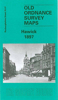
Hawick 1897
Hawick in 1897 in a fascinating series of reproductions of old Ordnance Survey plans in the Alan Godfrey Editions, ideal for anyone interested in the history of their neighbourhood or family. The map is double-sided. The main map covers the southern half of the town, with coverage from the High Street southward to Whitlaw Wood, and westward to Wilton Dean. Features include stretch of North British Railway, Slitrig Dyeworks, Stonefield Mill, Linnwood Mill, Hardie`s Hill, Workhouse, cemetery, Howlands Mill, Common Haugh, Town Hall, Public Park, Wilton Lodge, River Teviot, Hospital, St Mary`s church, etc. On the reverse is a portion of the adjacent map 25.03 extending coverage northward to include Wilton, railway station, Auction Mart, Riversdale Mills, Mansholme Mills,
Waverley Mills, Eastfield Mills, Glebe Mills, North Bridge, etc. About the Alan Godfrey Editions of the 25” OS Series:Selected towns in Great Britain and Ireland are covered by maps showing the extent of urban development in the last decades of the 19th and early 20th century. The plans have been taken from the Ordnance Survey mapping and reprinted at about 15 inches to one mile (1:4, 340). On the reverse most maps have historical notes and many also include extracts from contemporary directories. Most maps cover about one mile (1.6kms) north/south, one and a half miles (2.4kms) across; adjoining sheets can be combined to provide wider coverage.FOR MORE INFORMATION AND A COMPLETE LIST OF ALL AVAILABLE TITLES PLEASE CLICK ON THE SERIES LINK.
Waverley Mills, Eastfield Mills, Glebe Mills, North Bridge, etc. About the Alan Godfrey Editions of the 25” OS Series:Selected towns in Great Britain and Ireland are covered by maps showing the extent of urban development in the last decades of the 19th and early 20th century. The plans have been taken from the Ordnance Survey mapping and reprinted at about 15 inches to one mile (1:4, 340). On the reverse most maps have historical notes and many also include extracts from contemporary directories. Most maps cover about one mile (1.6kms) north/south, one and a half miles (2.4kms) across; adjoining sheets can be combined to provide wider coverage.FOR MORE INFORMATION AND A COMPLETE LIST OF ALL AVAILABLE TITLES PLEASE CLICK ON THE SERIES LINK.

Product Description
Reviews/Comments
Add New
Intelligent Comparison
Archived Product

Alnwick 1897 Stanfords
£3.50
Archived Product
Hawick Stanfords
£2.50
Vouchers
No voucher codes found.
Do you know a voucher code for this product or supplier? Add it to Insights for others to use.
Do you know a voucher code for this product or supplier? Add it to Insights for others to use.
 Denmark