More From Contributor
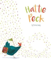
£8.99
In a controversial first novel that took the French literary world by storm & won the Prix de Flore, Tristan Garcia uses sex, friendships & love affairs to show what happens to people when political ideals
- Marxism, gay rights, sexual liberation, nationalism
- come to an end. As Elizabeth Levallois, a cultural journalist, looks back on the decade & on the ravages of the AIDS epidemic in Paris, a drama unfolds
- one in which love turns to hate & fidelity turns to betrayal, in both affairs of the heart & politics. With great verve & ingenuity, Garcia lays claim to an era that promised freedom as never before, & he paints an indelible, sharp, but sympathetic portrait of intellectuals lost in the age of MTV.


...
Archived Product
£3.50
Hatfield in 1896 in a fascinating series of reproductions of old Ordnance Survey plans in the Alan Godfrey Editions, ideal for anyone interested in the history of their neighbourhood or family. The map covers most of Hatfield, extending from the New Town eastward to Hatfield Park, & from Dagmar House & the Red Lion Hotel southward to the New Gardens. Features include Hatfield House, GNR railway with station, sidings & junction with St Albans line, St Etheldreda`s church, Lawn House, One Bell, Glebe Cottages, Rectory, Broomfield Cottages, Northcotts, St Audrey`s, Hatfield Workhouse, Primrose Cottages, White Lion pub, etc. On the reverse is an 1899 directory of Hatfield. About the Alan Godfrey Editions of the 25” OS Series: Selected towns in Great Britain & Ireland are covered by maps showing the extent of urban development in the last decades of the 19th & early 20th century. The plans have been taken from the Ordnance Survey mapping & reprinted at about 15 inches to one mile (1:4, 340). On the reverse most maps have historical notes & many also include extracts from contemporary directories. Most maps cover about one mile (1.6kms) north/south, one & a half miles (2.4kms) across; adjoining sheets can be combined to provide wider coverage.FOR MORE INFORMATION & A COMPLETE LIST OF ALL AVAILABLE TITLES PLEASE CLICK ON THE SERIES LINK. ...
Archived Product
£9.99
Hariya, sheet no. 2787-06, in the topographic survey of Nepal at 1:50, 000 published by the Nepali Government in the late 1990s & early 2000s & produced from remote sensing data by Finnish cartographers as part of that country’s international aid program. The maps cover 15’ x 15’ quadrangles.IMPORTANT – PLEASE NOTE BEFORE ORDERING: AVAILABILITY: although, theoretically at least, still in print, these maps are very difficult to get locally in Nepal and/or from various suppliers elsewhere specializing in obtaining such maps. DELIVERIES MAY TAKE SEVERAL WEEKS OR EVEN MONTHS.PROBLEMS WITH PLACE NAMES: reports from previous users indicate that transliteration of place names differs from that used widely not only on other maps & in guide books but also on the ground itself, in road signs & in the tourist & trekking industry in general. Whilst most names are similar enough to be easily recognizable, e.g. Namche Bajar for Namche Bazar or Lantan for Langtang, we have been told of confusion & difficulties arising from different spellings appearing on these maps.TREKKING ROUTES & TOURIST INFORMATION: whilst the maps show foot trails & mark locations of temples, etc, they carry no specific trekking information. Major trekking routes & places of interest are not highlighted. There is no marking for base camps & other tourist facilities. Map specifications: Contours are at 40m intervals, with graphics and/or coloring to show various features of the terrain (glaciers with moraines & crevasses, quarries, gravel or clay pits, etc.) & vegetation (forests, bush, grass, orchards & plantations, etc). Additional comments such as “open mixed forest mainly bajh & pine” annotate many area. The maps have numerous spot heights, but relatively few peaks are named. Areas outside the country’s borders are left blank. Settlements in remote areas are indicated by markings for individual buildings & the placing of names does not always make it clear which group of buildings they refer to. Road network distinguishes between major & minor foot trails. Symbols mark features such as temples, schools & hospitals, police stations, etc. Also shown are the country’s administrative divisions. The maps have a 1-km UTM grid, plus latitude & longitude lines at intervals of 5’. Map legend & all the text is in English. Coverage: the whole country is now covered, with the north at 1:50, 000, plus central & southern Nepal at 1:25, 000. The two series are complementary, do not overlap & use the same grid & numbering system (apart from the Lumbini Zone, where a different grid & numbering are used). For areas not shown on our grid & titles not listed here, please contact us by e-mail, but please do bear in mind the problems with availability & the likely very long delivery time. ...
Archived Product
£6.50
Topographic coverage of mainland Spain at 1:25, 000 published by the Centro Nacional de Información Geograficá, the country’s civilian survey organization. The maps have contours at 10m intervals & colouring and/or graphics to show different types of vegetation or land use. Boundaries of national parks & other protected areas are marked. In addition to all the usual information shown on topographic maps at this scale, detailed presentation of the road & rail networks, rural tracks & paths, etc, the maps also show campsites. The maps have a 1-km UTM grid, with margin ticks for latitude & longitude at 1` intervals. Map legend is in Spanish only.PLEASE NOTE: our grid for the whole of Spain is in preparation
- in the meantime, for areas other than those shown on the attached grid please use CNIG’s topographic survey at 1:50, 000 by searching for ‘SI00000832’. Each 25K map covers one quarter of the corresponding 50K map, with the numbering system: I = NW quarter, II = NE quarter, III = SW quarter & IV = SE quarter. CNIG maps in the Provincial Road Maps series at 1:200, 000 are overprinted with the grid for the 1:50, 000 survey & can be used to see the area covered by each 50K or 25K title in more detail. To see the list of titles in this series please click on the series grid
- for map numbers not yet listed on our website please contact us by email.

...
Archived Product
£23.99
Map No. 10115, Hattfjelldal, in the new topographic survey of Norway at 1:50, 000 covering the country on 195 double-sided sheets & first published by Nordeca in 2011
- 2012; fully GPS compatible, indicating waymarked footpaths, campsites, tourist huts, illuminated ski runs, etc. The maps, now published by Nordeca, the successors to Statens Kartverk & its subsequent owners the Ugland Group, are printed on light, waterproof & tear-resistant synthetic paper. Each map covers an area of 62x 45 kilometres (39 x 28 miles approx.), with a 2-km overlap between the sheets. The maps have contours at 20m intervals (10m glacier contours), plus colouring & graphics to show cultivated areas, bogs, forests, etc. In addition to all the information expected of topographic mapping at this scale the maps distinguish between waymarked & unmarked footpaths & show campsites, tourist huts (serviced/self service/no supplies), country hotels & restaurants, & illuminated ski trails. The series uses EUREF89 (WGS84) datum & the maps have a 1-km UTM grid. Map legend is in Norwegian & English. Each title comes in a sturdy protective card envelope.
...
Archived Product
£3.95
Hattingen in 1944 in the Alan Godfrey series of reproductions of British War Office survey first published in 1945 prior to the Allied occupation of the area. The map covers Hattingen, Welper, Blankenstein & Dahlhausen. Features include Hattingen city centre, Henrichshütten steel works, Blankenstein village, Holthausen, Bredenscheid, Baak, Baaker Mulde mine, Klyff Manor House, railways, River Ruhr, Altendorf, Dahlhausen, Linden. To see other titles in this series please click on the series link. This series of reproductions from Alan Godfrey covers the major industrial area east of the Rhine that

Includes::
Bochum, Cologne, Dortmund, Duisburg, Düsseldorf, Essen, Gelsenkirchen, Oberhausen & other towns, with their great network of railways & industries. The maps are taken from the British War Office 1:12, 500 plans & reduced at Approx. 1:19, 000. Published in 1945, prior to the Allied occupation of the area, the maps are especially good at showing industry, collieries & transport. They are not bombing maps
- indeed, they make clear that allowance is not made for bomb damage
- but show the areas with all their industrial sites & railways largely as they were before the bombing raids of 1943-44. The maps have additional information added by British intelligence. This is normally accurate but allowance must be made for the `fog of war` & occasional spelling mistakes, etc. Each title has on the reverse a specially written introduction to the area in English, with a shorter text in German. Map legend is in English only.


...
Archived Product
£3.50
Hatton in 1935 in a fascinating series of reproductions of old Ordnance Survey plans in the Alan Godfrey Editions, ideal for anyone interested in the history of their neighbourhood or family. The map covers an area just east of Heathrow, from Hatton village northward to Berkeley Avenue at Cranford. Features include Hatton Farm, St Anthony`s Home, Dog & Partridge inn, Hatton Road Farm, River Crane, isolation hospital, & Byron Avenue area. Most of the area west of the River Crane has today been covered with Heathrow infrastructure. On the reverse are 1933 directories for East Bedfont, Hatton & Cranford. About the Alan Godfrey Editions of the 25” OS Series: Selected towns in Great Britain & Ireland are covered by maps showing the extent of urban development in the last decades of the 19th & early 20th century. The plans have been taken from the Ordnance Survey mapping & reprinted at about 15 inches to one mile (1:4, 340). On the reverse most maps have historical notes & many also include extracts from contemporary directories. Most maps cover about one mile (1.6kms) north/south, one & a half miles (2.4kms) across; adjoining sheets can be combined to provide wider coverage.FOR MORE INFORMATION & A COMPLETE LIST OF ALL AVAILABLE TITLES PLEASE CLICK ON THE SERIES LINK. ...
Archived Product
£17.99
The 1:50, 000 topographic map gives a more general picture of the ground features than a basic map. It shows settlements, houses, roads, cultivated areas, waterways, cutting areas, mires, rock exposures, & relief. One map sheet covers an area of 30 x 40 km & one centimetre corresponds to 500 metres on the ground. The 1:50, 000 topographic map is also an ideal complement to nautical charts as it provides useful information about the land areas adjacent to waterways. For example, all Finnish sea areas are covered by 1:50, 000 topographic map sheets. ...
Archived Product
£12.99
Hauenstein
- Belchenflue area of the Swiss Jura at 1:33, 333 on light, waterproof & tear-resistant map No. 3325T published by
...
Archived Product
£12.99
Map No. 1088, Hauenstein, in the topographic survey of Switzerland at 1:25, 000 from Bundesamt für Landestopographie (swisstopo), covering the whole country on 247 small format sheets, with special larger maps published for popular regions including some titles now available in hiking versions. Highly regarded for their superb use of graphic relief & hill shading, the maps give an almost 3-D picture of Switzerland`s mountainous terrain. Contours are at 10 m intervals, with 20m intervals in the mountainous areas. All the maps have a 1-km grid for Swiss national coordinates (datum CH 1903). * Small format sheets (Nos. 1011
- 1374)* Map legend in the language of the area covered by the map. Additional margin ticks show latitude & longitude in steps of 2`. The area covered by each map is 17 x 12 km (11 x 7 miles approx). * Special larger sheets (Nos. from 2501 onwards) – STANDARD editions:* No map legend is included but a separate leaflet can be provided instead. The area covered by each map is 25 x 17 km (15 x 11 miles approx).* Special larger sheets (Nos. from 2501 onwards) – HIKING editions:* An overprint highlights hiking, mountain & alpine paths, including regional & national long-distance trails. The maps also show bus routes with bus stops, plus inns in remote locations. The area covered by each map is 25 x 17 km (15 x 11 miles approx).
...
Archived Product

Hattie Peck

Hattie Peck is a heart-warming picture storybook from Top That Publishing about triumph in the face of adversity. A perfect bedtime story for boys and girls aged 3+.Little Hattie Peck loved eggs! Big ones, small ones, speckled ones. All she wanted was an egg of her own. One day Hattie left her cosy coop on an adventure to find all the abandoned eggs of the world. And find them she did! But what will happen when they hatch? Hattie Peck is written and illustrated by the enormously talented Emma Levey. Hattie Peck reached the finals of the AOi Awards in 2015.All Top That Publishing storybooks are printed on superior paper stock and benefit from special cover finishes making them perfect to give as a present or gift.
RIP - This product is no longer available on our network. It was last seen on 25.09.2019

This page now acts as a permanent archive for this product. Add more information using the comments box below to ensure it can still be found by future generations.

Use our search facility to see if it is available from an alternative contributor.
  • External links may include paid for promotion
  • Availability: Out Of Stock
  • Supplier: Stanfords
  • SKU: 9781787004450
Availability: In Stock
£6.99

Product Description

Hattie Peck is a heart-warming picture storybook from Top That Publishing about triumph in the face of adversity. A perfect bedtime story for boys & girls aged 3+. Little Hattie Peck loved eggs! Big ones, small ones, speckled ones. All she wanted was an egg of her own. One day Hattie left her cosy coop on an adventure to find all the abandoned eggs of the world. & find them she did! But what will happen when they hatch? Hattie Peck is written & illustrated by the enormously talented Emma Levey. Hattie Peck reached the finals of the AOi Awards in 2015. All Top That Publishing storybooks are printed on superior paper stock & benefit from special cover finishes making them perfect to give as a present or gift.

Reviews/Comments

Add New

Intelligent Comparison

Oooops!
We couldn't find anything!
Perhaps this product's unique.... Or perhaps we are still looking for comparisons!
Click to bump this page and we'll hurry up.

Price History

Vouchers

No voucher codes found.
Do you know a voucher code for this product or supplier? Add it to Insights for others to use.

Facebook

Jargon Buster

Paper - A thin sheet mainly used for writing. Available in a variety of colours. Made mainly from wood pulp.
World - A physical grouping, commonly used to describe earth and everything associated with ti
Gift - Something that is presented without expecting anything in return
Day - The time it takes a planet or other space objects to complete one rotation.
Heart - An organ that pumps blood around the body. Usually related to love.
Small - something that takes up less space than normal.
Adventure - an undertaking of an exciting challenge or experience.

Supplier Information

Stanfords
Stanfords was established in 1853 and opened their iconic Covent Garden flagship store in 1901. They have become the top retailer of maps, travel books and accessories in the UK and arguably offer the largest selection of maps and travel books worldwide. Famous names such as Captain Robert Falcon Scott, Ranulph Fiennes and Michael Palin have purchased from Stanfords. They now have a shop in Bristol and both stores together with other venues operate a calendar of events including talks, book signings and exhibitions. As a specialist map retailer, the map selection is comprehensive and includes road maps, street maps and walking maps from worldwide destinations, as well as a selection of world atlases and wall maps. Books include travel guides and travel literature. Stanfords also stock globes, from miniatures made of blue marble to magnificent floor-standing globes. The website features a selection of interesting articles on travel topics.
Page Updated: 2023-11-12 20:15:36

Community Generated Product Tags

Oh No! The productWIKI community hasn't generated any tags for this product yet!
Menu