
 United Kingdom
 France
 Germany
 Netherlands
 Sweden
 USA
USA
 Italy
Italy
 Spain
Spain
More From Contributor


Hartlepool West 1896
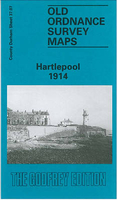
West Hartlepool in 1896 in a fascinating series of reproductions of old Ordnance Survey plans in the Alan Godfrey Editions, ideal for anyone interested in the history of their neighbourhood or family. Three versions of this map have been published, showing how the area developed across the years. They cover West Hartlepool - the new town created by Ward Jackson in the mid 19th century as a major shipbuilding and coal shipping port. The town developed from the old hamlet of New Stranton. Coverage stretches from Bengal Street eastward to the coast and from Middleton and Central Dock southward to Musgrave Street. The early 1857 edition shows the town developing around Christ Church and Church Street. Features include Middleton, Jackson Dock, Timber Dock, many coal drops, Harbour
Terrace, Albert Square, station (on Mainsforth Terrace), West Harbour, New Road, gasworks, etc. There is very little development west of Stockton Street. Surveyed in 1857, the map was updated to 1873. Extracts from an early trade directory are on the reverse.By the 1894 edition development had spread further west and features include Town Hall, York Road area, St Josephs RC church, station (on present site), goods station, Swainson Dock, more timber ponds, graving docks, engine shed, more railways and development around the docks. The 1914 version is even more built up and includes St Oswald`s church, Victoria football ground, Union Dock, tramways, etc. Extracts from a contemporary street directory, including Jackson Street, Middleton Road, Stockton Street, Tower
Street and Victoria Road are on the reverse.About the Alan Godfrey Editions of the 25” OS Series:Selected towns in Great Britain and Ireland are covered by maps showing the extent of urban development in the last decades of the 19th and early 20th century. The plans have been taken from the Ordnance Survey mapping and reprinted at about 15 inches to one mile (1:4, 340). On the reverse most maps have historical notes and many also include extracts from contemporary directories. Most maps cover about one mile (1.6kms) north/south, one and a half miles (2.4kms) across; adjoining sheets can be combined to provide wider coverage.FOR MORE INFORMATION AND A COMPLETE LIST OF ALL AVAILABLE TITLES PLEASE CLICK ON THE SERIES LINK.

Product Description
Reviews/Comments
Add New
Intelligent Comparison
Archived Product

Hartlepool West 1914 Stanfords
£3.50
Archived Product
Hartlepool 1914 Stanfords
£3.50
Vouchers
No voucher codes found.
Do you know a voucher code for this product or supplier? Add it to Insights for others to use.
Do you know a voucher code for this product or supplier? Add it to Insights for others to use.
 Denmark