More From Contributor
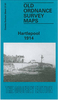
£6.99
Back in England following his heroics in the Zulu Wars, George Hart is summoned to a new adventure when Prime Minister Disraeli asks him to go on a secret mission to Afghanistan, where the British fear Muslim extremists are poised to overthrow the local ruler & threaten the jewel in the Imperial crown, India. Hart has severe misgivings. Always an outsider in British society, he doesn`t like Whitehall`s arrogant way of meddling in other people`s religious & political affairs, but desperate for money, he takes the job & descends the Khyber Pass into a strange & violent l&. When his warnings are ignored by the pompous British Resident in Kabul, a terrible massacre occurs & soon Hart is on the run with a beautiful Afghan princess, in a race to prevent an uprising & head off a catastrophic British invasion. ...
Archived Product
£2.99
Hartland & Clovelly area of northern Devon on a very detailed, GPS compatible hiking, cycling & horse riding map from Croydecycle at 1:12, 500, printed on light, waterproof & tear-resistant synthetic paper. The map is part of publishers’ series covering the western coast of Somerset, both coastlines of Devon, & the adjoining areas of Dorset. Each handy size, 50 x 35cm, map is double-sided to cover a wider area. Topography is indicated by contours at 10m intervals with graphics and/or colouring for different type of terrain (s&, shingle, mud, high or low cliffs, etc) & vegetation (woodlands, gorse, scrub, etc). An overprint highlights footpaths, permissive paths & small permissive paths, Bridleways, cycle tracks & country roads which are byways for all traffic. On other roads markings indicate routes which are part of the National Cycle Network. Symbols show locations of campsites & caravan sites, riding stables, pubs/cafes/restaurants, shops & other local facilities, etc. For GPS users each map has in the margins National Grid coordinates. Most 1:12, 500 maps include enlargements of main town (s), an inset providing geological information, & details of transport options. To see other titles in this series, including cycle maps, please click on the series link. The 1:12, 500 maps are numbered on our website westwards along the Somerset & north Devon coast, & then eastwards along the southern coast of Devon & into Dorset. ...
Archived Product
£2.95
West Hartlepool in 1857-73 in a fascinating series of reproductions of old Ordnance Survey plans in the Alan Godfrey Editions, ideal for anyone interested in the history of their neighbourhood or family. Selected towns in Great Britain & Ireland are covered by maps showing the extent of urban development in the last decades of the 19th & early 20th century. In this title: three versions of this map have been published, showing how the area developed across the years. They cover West Hartlepool
- the new town created by Ward Jackson in the mid 19th century as a major shipbuilding & coal shipping port. The town developed from the old hamlet of New Stranton. Coverage stretches from Bengal Street eastward to the coast & from Middleton & Central Dock southward to Musgrave Street. The early 1857 edition shows the town developing around Christ Church & Church Street. Features include Middleton, Jackson Dock, Timber Dock, many coal drops, Harbour Terrace, Albert Square, station (on Mainsforth Terrace), West Harbour, New Road, gasworks. There is very little development west of Stockton Street. Surveyed in 1857, the map was updated to 1873. Extracts from an early trade directory are included on the reverse. By the 1894 edition development had spread further west & features include Town Hall, York Road area, St Josephs RC church, station (on present site), goods station, Swainson Dock, more timber ponds, graving docks, engine shed, more railways & development around the docks. The 1914 version is even more built up &

Includes::
St Oswald's church, Victoria football ground, Union Dock, tramways. Extracts from a contemporary street directory, including Jackson Street, Middleton Road, Stockton Street, Tower Street, Victoria Road are on the reverse. About the Alan Godfrey Editions of the 25


...
Archived Product
£3.50
West Hartlepool in 1896 in a fascinating series of reproductions of old Ordnance Survey plans in the Alan Godfrey Editions, ideal for anyone interested in the history of their neighbourhood or family. Three versions of this map have been published, showing how the area developed across the years. They cover West Hartlepool
- the new town created by Ward Jackson in the mid 19th century as a major shipbuilding & coal shipping port. The town developed from the old hamlet of New Stranton. Coverage stretches from Bengal Street eastward to the coast & from Middleton & Central Dock southward to Musgrave Street. The early 1857 edition shows the town developing around Christ Church & Church Street. Features include Middleton, Jackson Dock, Timber Dock, many coal drops, Harbour Terrace, Albert Square, station (on Mainsforth Terrace), West Harbour, New Road, gasworks, etc. There is very little development west of Stockton Street. Surveyed in 1857, the map was updated to 1873. Extracts from an early trade directory are on the reverse. By the 1894 edition development had spread further west & features include Town Hall, York Road area, St Josephs RC church, station (on present site), goods station, Swainson Dock, more timber ponds, graving docks, engine shed, more railways & development around the docks. The 1914 version is even more built up &

Includes::
St Oswald`s church, Victoria football ground, Union Dock, tramways, etc. Extracts from a contemporary street directory, including Jackson Street, Middleton Road, Stockton Street, Tower Street & Victoria Road are on the reverse. About the Alan Godfrey Editions of the 25” OS Series: Selected towns in Great Britain & Ireland are covered by maps showing the extent of urban development in the last decades of the 19th & early 20th century. The plans have been taken from the Ordnance Survey mapping & reprinted at about 15 inches to one mile (1:4, 340). On the reverse most maps have historical notes & many also include extracts from contemporary directories. Most maps cover about one mile (1.6kms) north/south, one & a half miles (2.4kms) across; adjoining sheets can be combined to provide wider coverage.FOR MORE INFORMATION & A COMPLETE LIST OF ALL AVAILABLE TITLES PLEASE CLICK ON THE SERIES LINK.


...
Archived Product
£3.50
West Hartlepool in 1914 in a fascinating series of reproductions of old Ordnance Survey plans in the Alan Godfrey Editions, ideal for anyone interested in the history of their neighbourhood or family. Three versions of this map have been published, showing how the area developed across the years. They cover West Hartlepool
- the new town created by Ward Jackson in the mid 19th century as a major shipbuilding & coal shipping port. The town developed from the old hamlet of New Stranton. Coverage stretches from Bengal Street eastward to the coast & from Middleton & Central Dock southward to Musgrave Street. The early 1857 edition shows the town developing around Christ Church & Church Street. Features include Middleton, Jackson Dock, Timber Dock, many coal drops, Harbour Terrace, Albert Square, station (on Mainsforth Terrace), West Harbour, New Road, gasworks, etc. There is very little development west of Stockton Street. Surveyed in 1857, the map was updated to 1873. Extracts from an early trade directory are on the reverse. By the 1894 edition development had spread further west & features include Town Hall, York Road area, St Josephs RC church, station (on present site), goods station, Swainson Dock, more timber ponds, graving docks, engine shed, more railways & development around the docks. The 1914 version is even more built up &

Includes::
St Oswald`s church, Victoria football ground, Union Dock, tramways, etc. Extracts from a contemporary street directory, including Jackson Street, Middleton Road, Stockton Street, Tower Street & Victoria Road are on the reverse. About the Alan Godfrey Editions of the 25” OS Series: Selected towns in Great Britain & Ireland are covered by maps showing the extent of urban development in the last decades of the 19th & early 20th century. The plans have been taken from the Ordnance Survey mapping & reprinted at about 15 inches to one mile (1:4, 340). On the reverse most maps have historical notes & many also include extracts from contemporary directories. Most maps cover about one mile (1.6kms) north/south, one & a half miles (2.4kms) across; adjoining sheets can be combined to provide wider coverage.FOR MORE INFORMATION & A COMPLETE LIST OF ALL AVAILABLE TITLES PLEASE CLICK ON THE SERIES LINK.


...
Archived Product
£2.95
Hartlepool in 1914 in a fascinating series of reproductions of old Ordnance Survey plans in the Alan Godfrey Editions, ideal for anyone interested in the history of their neighbourhood or family. Selected towns in Great Britain & Ireland are covered by maps showing the extent of urban development in the last decades of the 19th & early 20th century. In this title: two versions of this map are available, showing how the area developed across the years. Both maps are double-sided to provide maximum coverage. They cover the Headland area of Hartlepool
- the original town
- & coverage extends westward to include Victoria Dock, the Old Harbour, Throston Ward & Hartlepool Cemetery. The early 1857 edition covers the original town around St Hilda's church, Market Place, High Street, railway terminus, Friarage Close, Farwell Field, Trinity church, Victoria Dock, Tide Harbour, Hart Warren, Warren Cement Works, Milbank Forge, The Sleake, Warrenm Hall. West of the Tide Harbour there is little development, but Cleveland Road is shown built across an empty landscape. The 1914 map
- the year of Hartlepool's ' Bombardment'
- is far more developed. The Headland area is again shown in full, but west of that around Victoria Dock & what is now called Old Harbour are many railway & industrial developments including Fish Quay, Hartlepool Engine Works, station, engine sheds, Central Marine Engine Works, Central Shipbuilding Yard, Greenland Creosote Works, North Basin, Cemetery Battery, Fort Sanitary Hospital. About the Alan Godfrey Editions of the 25


...
Archived Product
£3.50
Hartlepool in 1914 in a fascinating series of reproductions of old Ordnance Survey plans in the Alan Godfrey Editions, ideal for anyone interested in the history of their neighbourhood or family. Two versions of this map have been published, showing how the area developed across the years. Both maps are double-sided to provide maximum coverage. They cover the Headland area of Hartlepool
- the original town
- extendin westward to include Victoria Dock, the Old Harbour, Throston Ward & Hartlepool Cemetery. The early 1857 edition covers the original town around St Hilda`s church, Market Place, High Street, railway terminus, Friarage Close, Farwell Field, Trinity church, Victoria Dock, Tide Harbour, Hart Warren, Warren Cement Works, Milbank Forge, The Sleake, Warrenm Hall, etc. West of the Tide Harbour there is little development, but Cleveland Road is shown built across an empty landscape. The 1914 map
- the year of Hartlepool`s ` Bombardment`
- is far more developed. The Headland area is again shown in full, but west of that around Victoria Dock & what is now called Old Harbour are many railway & industrial developments including Fish Quay, Hartlepool Engine Works, station, engine sheds, Central Marine Engine Works, Central Shipbuilding Yard, Greenland Creosote Works, North Basin, Cemetery Battery & Fort Sanitary Hospital. About the Alan Godfrey Editions of the 25” OS Series: Selected towns in Great Britain & Ireland are covered by maps showing the extent of urban development in the last decades of the 19th & early 20th century. The plans have been taken from the Ordnance Survey mapping & reprinted at about 15 inches to one mile (1:4, 340). On the reverse most maps have historical notes & many also include extracts from contemporary directories. Most maps cover about one mile (1.6kms) north/south, one & a half miles (2.4kms) across; adjoining sheets can be combined to provide wider coverage.FOR MORE INFORMATION & A COMPLETE LIST OF ALL AVAILABLE TITLES PLEASE CLICK ON THE SERIES LINK.


...
Archived Product
£2.95
Hartley & St Mary's Island in 1896 in a fascinating series of reproductions of old Ordnance Survey plans in the Alan Godfrey Editions, ideal for anyone interested in the history of their neighbourhood or family. Selected towns in Great Britain & Ireland are covered by maps showing the extent of urban development in the last decades of the 19th & early 20th century. In this title: the map combines most of sheet 81.11 which

Includes::
the old village of Hartley, with coverage westward to Seaton Burn & Hartley West Farm, & all of sheet 81.12 with Curry's Point & the ever popular St Mary's Isl&, sometimes called Bait Isl&. On the reverse coverage is extended further south along the coast, towards Whitley Sands, & features include Hartley South Farm, Culvert Inn & Prudhoe Memorial Convalescent Home, then standing in splendid isolation. About the Alan Godfrey Editions of the 25

...
Archived Product
£3.50
Hartley & St Mary`s Island in 1896 in a fascinating series of reproductions of old Ordnance Survey plans in the Alan Godfrey Editions, ideal for anyone interested in the history of their neighbourhood or family. The map combines most of sheet 81.11 which

Includes::
the old village of Hartley with coverage westward to Seaton Burn & Hartley West Farm, plus all of sheet 81.12 with Curry`s Point & the ever popular St Mary`s Isl&, sometimes called Bait Isl&. On the reverse coverage is extended further south along the coast, towards Whitley Sands, & features include Hartley South Farm, Culvert Inn & Prudhoe Memorial Convalescent Home, then standing in splendid isolation. About the Alan Godfrey Editions of the 25” OS Series: Selected towns in Great Britain & Ireland are covered by maps showing the extent of urban development in the last decades of the 19th & early 20th century. The plans have been taken from the Ordnance Survey mapping & reprinted at about 15 inches to one mile (1:4, 340). On the reverse most maps have historical notes & many also include extracts from contemporary directories. Most maps cover about one mile (1.6kms) north/south, one & a half miles (2.4kms) across; adjoining sheets can be combined to provide wider coverage.FOR MORE INFORMATION & A COMPLETE LIST OF ALL AVAILABLE TITLES PLEASE CLICK ON THE SERIES LINK.

...
Archived Product
£3.50
Harton in 1895 in a fascinating series of reproductions of old Ordnance Survey plans in the Alan Godfrey Editions, ideal for anyone interested in the history of their neighbourhood or family. The map stretches westward to include Tyne Dock Ward, northwards to St Marks vicarage & south to South Shields Union Workhouse. Features include St Peters Church, Harton Hall, St Mary`s Church, NER Railway line & station, football ground, Deans Hospital, Harton Cemetery & West End Park. Main streets include Hudson Street, Sunderland Road, Bertram Street & Westoe Parade. On the reverse is a section of a map for West Harton plus an extract from a directory for the area. About the Alan Godfrey Editions of the 25” OS Series: Selected towns in Great Britain & Ireland are covered by maps showing the extent of urban development in the last decades of the 19th & early 20th century. The plans have been taken from the Ordnance Survey mapping & reprinted at about 15 inches to one mile (1:4, 340). On the reverse most maps have historical notes & many also include extracts from contemporary directories. Most maps cover about one mile (1.6kms) north/south, one & a half miles (2.4kms) across; adjoining sheets can be combined to provide wider coverage.FOR MORE INFORMATION & A COMPLETE LIST OF ALL AVAILABLE TITLES PLEASE CLICK ON THE SERIES LINK. ...
Archived Product

Hartlepool 1857

Hartlepool in 1857 in a fascinating series of reproductions of old Ordnance Survey plans in the Alan Godfrey Editions, ideal for anyone interested in the history of their neighbourhood or family. Selected towns in Great Britain and Ireland are covered by maps showing the extent of urban development in the last decades of the 19th and early 20th century.In this title: two versions of this map are available, showing how the area developed across the years. Both maps are double-sided to provide maximum coverage. They cover the Headland area of Hartlepool - the original town - and coverage extends westward to include Victoria Dock, the Old Harbour, Throston Ward and Hartlepool Cemetery. The early 1857 edition covers the original town around St Hilda's church, Market Place, High Street,
railway terminus, Friarage Close, Farwell Field, Trinity church, Victoria Dock, Tide Harbour, Hart Warren, Warren Cement Works, Milbank Forge, The Sleake, Warrenm Hall. West of the Tide Harbour there is little development, but Cleveland Road is shown built across an empty landscape. The 1914 map - the year of Hartlepool's 'Bombardment' - is far more developed. The Headland area is again shown in full, but west of that around Victoria Dock and what is now called Old Harbour are many railway and industrial developments including Fish Quay, Hartlepool Engine Works, station, engine sheds, Central Marine Engine Works, Central Shipbuilding Yard, Greenland Creosote Works, North Basin, Cemetery Battery, Fort Sanitary Hospital.About the Alan Godfrey Editions of the 25
RIP - This product is no longer available on our network. It was last seen on 13.12.2014

This page now acts as a permanent archive for this product. Add more information using the comments box below to ensure it can still be found by future generations.

Use our search facility to see if it is available from an alternative contributor.
  • External links may include paid for promotion
  • Availability: Out Of Stock
  • Supplier: Stanfords
  • SKU: X41675
Availability: In Stock
£2.95

Product Description

Hartlepool in 1857 in a fascinating series of reproductions of old Ordnance Survey plans in the Alan Godfrey Editions, ideal for anyone interested in the history of their neighbourhood or family. Selected towns in Great Britain & Ireland are covered by maps showing the extent of urban development in the last decades of the 19th & early 20th century. In this title: two versions of this map are available, showing how the area developed across the years. Both maps are double-sided to provide maximum coverage. They cover the Headland area of Hartlepool
- the original town
- & coverage extends westward to include Victoria Dock, the Old Harbour, Throston Ward & Hartlepool Cemetery. The early 1857 edition covers the original town around St Hilda's church, Market Place, High Street, railway terminus, Friarage Close, Farwell Field, Trinity church, Victoria Dock, Tide Harbour, Hart Warren, Warren Cement Works, Milbank Forge, The Sleake, Warrenm Hall. West of the Tide Harbour there is little development, but Cleveland Road is shown built across an empty landscape. The 1914 map
- the year of Hartlepool's ' Bombardment'
- is far more developed. The Headland area is again shown in full, but west of that around Victoria Dock & what is now called Old Harbour are many railway & industrial developments including Fish Quay, Hartlepool Engine Works, station, engine sheds, Central Marine Engine Works, Central Shipbuilding Yard, Greenland Creosote Works, North Basin, Cemetery Battery, Fort Sanitary Hospital. About the Alan Godfrey Editions of the 25

Reviews/Comments

Add New

Intelligent Comparison

Oooops!
We couldn't find anything!
Perhaps this product's unique.... Or perhaps we are still looking for comparisons!
Click to bump this page and we'll hurry up.

Price History

Vouchers

No voucher codes found.
Do you know a voucher code for this product or supplier? Add it to Insights for others to use.

Facebook

Jargon Buster

Engine - A machine designed to convert fuel into motion
Battery - A device used for the storage of electricity
History - Anything that happens in the past. An acedemic subject.
Year - The time it takes the planet earth to orbit the sun. This takes around 365.25 days.
Fish - A creature that lives in water. A fish uses gills to breath unlike mammals
Road - a manmade lane or a path that is used to speed up travel.
Hall - A room at the inside of an entrance of a house.
Year - 365 days (366 days in a leap year), the time taken for planet earth to make one full revolution around the sun.
Ideal - Something that satisfies a perfect criteria.
Family - A group of people that live together made up from parents and children.

Supplier Information

Stanfords
Stanfords was established in 1853 and opened their iconic Covent Garden flagship store in 1901. They have become the top retailer of maps, travel books and accessories in the UK and arguably offer the largest selection of maps and travel books worldwide. Famous names such as Captain Robert Falcon Scott, Ranulph Fiennes and Michael Palin have purchased from Stanfords. They now have a shop in Bristol and both stores together with other venues operate a calendar of events including talks, book signings and exhibitions. As a specialist map retailer, the map selection is comprehensive and includes road maps, street maps and walking maps from worldwide destinations, as well as a selection of world atlases and wall maps. Books include travel guides and travel literature. Stanfords also stock globes, from miniatures made of blue marble to magnificent floor-standing globes. The website features a selection of interesting articles on travel topics.
Page Updated: 2023-11-12 20:15:36

Community Generated Product Tags

Oh No! The productWIKI community hasn't generated any tags for this product yet!
Menu