More From Contributor
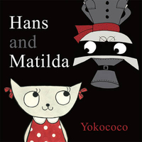
£12.99
Hanover
- Steinhuder Meer
- Deister area in Germany at 1:50, 000 from Kümmerly+ Frey in a series GPS compatible, double-sided

...
Archived Product
£8.99
Falk, one of Germany`s leading publishers of street plans, produce their town plans in two different formats. Falk Extra plans are folded in a standard way, where the whole map can be opened to view the entire area it covers. For larger cities, the same mapping is also published with a special folding system designed to show only a small section of the map at one time. The whole map can be opened but it will be cut in several places. Many find these street plans very user-friendly & easier to handle than conventional maps. The plans, which cover towns with their outer suburbs, indicate main landmarks & public buildings & show all the public transport facilities, one way streets & car parks. Plans of lager cities include a separate map of the town centre at a more detailed scale & a diagram of the underground & the suburban rail network. The plans also show the postal divisions & have an extensive street index which, where appropriate, shows individual postal codes for each street. Map legend

Includes::
English. Falk Extra plans also include on the reverse a road map of the surrounding area.

...
Archived Product
£9.99
Indexed street map of Hanover at 1:20, 000 from Freytag & Berndt with an enlargement of central Hanover at 1:10, 000. Mapping is bright, colourful & clear, with one-way streets shown, as well as the S-bahn, bus & tram networks with stops clearly indicated. Points of interest such as Hanover’s 40 theatres, the Historic Museum, & parks are marked, as are local facilities. The enlargement of central Hanover shares the same mapping but with more clarity, & is indexed along with the main map on the reverse.A diagram of Hanover`s GVH Network (S-bahn, bus & tram) included. Map legend

Includes::
English.

...
Archived Product
£9.99
Unusual, very attractive street plan of Hannover from Bollmann, offering a bird’s-eye view of the city with every building drawn to scale with full architectural detail, from street arcades to rooftops & inner courtyards. The plan, drawn in 2010, covers central Hannover from the AWD Arena & Waterlooplatz in the west to the Stadthalle in the east & is annotated with small icons of various businesses which sponsored its production. On the reverse is a conventional street plan of the city with its outer suburbs. Street index, in a separate booklet, covers both plans &

Includes::
brief descriptions of the main monuments & places of interest, plus lists of local facilities & various shops & other businesses. All the text is in German only.

...
Archived Product
£10.99
Hanover region on a road map based on the country’s topographic survey at 1:200, 000 from the Bundesamt für Kartographie und Geodäsie, Germany’s federal mapping agency. On the reverse is a road map of northern Germany at 1:1, 000, 000. Maps in this series cover selected regions of Germany
- the environs on main cities & parts of the Rhine Valley. Bundesamt für Kartographie und Geodäsie is the federal cartographic agency of Germany responsible for topographic mapping at 1:200, 000 & maps at smaller scales (the more detailed topographic & leisure maps are prepared & published by the survey organizations of the individual states). Cartography is from the 200K topographic survey & the maps have very elegant, modern look whilst retaining the traditional German presentation of names of smaller towns & villages in italics. Contours are at 25m intervals, enhanced by relief shading, with colouring for woodlands, vineyards & hop plantations. Road network, graded into five types, highlights in colour national & regional roads; no driving distances are marked Railway network is also shown in detail, with stations, goods only lines, etc. The maps show administrative boundaries of states & counties, & have a UTM grid plus margin ticks for latitude & longitude at 2’ intervals. Map legend is in German only.IMPORTANT
- PLEASE NOTE: maps in this series provide an excellent presentation of the areas covered by them, with plenty of place names & detailed representation of the road network, & will appeal to anyone who likes quality cartography, but they are not necessarily the best option for holiday & business travel. To see other titles in this series please click on the series link.

...
Archived Product
£14.99
Hansel & Gretel is a timeless tale that has been told to children the world over for two hundred years, & yet Louise Rowe has managed to breathe even more wonder into this fantastic tale. Illustrated in shades of green with touches of other colours, & with stunning pop-ups, it ...
Archived Product
£29.99
Topographic survey of Denmark at 1:100, 000 from Kort & Matrikelstyrelsen, the country’s national survey organization. The maps have contours at 5 metre intervals, with colouring and/or graphics showing various types of terrain & land use: woodlands, orchards, heath, sand & dunes, tidal flats, meadows & marshl&, etc. The maps provide detailed presentation of the road & rail networks & other information expected of topographic mapping at this scale. No specifically tourist information such as waymarked cycling or hiking routes is shown. Standard size sheets cover an area of 56 x 45km / 35x 28 miles approx. Map legend

Includes::
English. To see other titles in this series please click on the series link.IMPORTANT – PLEASE NOTE BEFORE ORDERING:AVAILABILITY: all the maps are now printed on dem&. Delivery from Denmark can take over 4 weeks. Once an order has been placed we cannot accept any returns for credit.COORDINATES: although the maps are meant to have UTM coordinates for EUREF 89 (WGS 84) datum, sheets are sometimes delivered printed without any grid or margin ticks for UTM or latitude & longitude.

...
Archived Product
£3.50
Hanwell & Norwood Green in 1894 in a fascinating series of reproductions of old Ordnance Survey plans in the Alan Godfrey Editions, ideal for anyone interested in the history of their neighbourhood or family. Two versions of this map have been published to show how the area developed across the years. The maps cover the southern portion of Hanwell around St Mark`s church in the north-eastern corner, extending south & west to include the village of Norwood Green, with St Mary`s church in the south-western corner. The GWR Brentford branch, Windmill Lane, & the Grand Junction Canal run through the map. The principal feature is the Hanwell Lunatic Asylum, opened in 1831, & part of the map covers the northern section of Osterley Park. Extracts from early directories on the reverse on the 1894 map; the 1934 map has entries K-Z of the Hanwell entry from a 1933 directory. About the Alan Godfrey Editions of the 25” OS Series: Selected towns in Great Britain & Ireland are covered by maps showing the extent of urban development in the last decades of the 19th & early 20th century. The plans have been taken from the Ordnance Survey mapping & reprinted at about 15 inches to one mile (1:4, 340). On the reverse most maps have historical notes & many also include extracts from contemporary directories. Most maps cover about one mile (1.6kms) north/south, one & a half miles (2.4kms) across; adjoining sheets can be combined to provide wider coverage.FOR MORE INFORMATION & A COMPLETE LIST OF ALL AVAILABLE TITLES PLEASE CLICK ON THE SERIES LINK. ...
Archived Product
£3.50
Hanwell & Norwood Green in 1934 in a fascinating series of reproductions of old Ordnance Survey plans in the Alan Godfrey Editions, ideal for anyone interested in the history of their neighbourhood or family. Two versions of this map have been published to show how the area developed across the years. The maps cover the southern portion of Hanwell around St Mark`s church in the north-eastern corner, extending south & west to include the village of Norwood Green, with St Mary`s church in the south-western corner. The GWR Brentford branch, Windmill Lane, & the Grand Junction Canal run through the map. The principal feature is the Hanwell Lunatic Asylum, opened in 1831, & part of the map covers the northern section of Osterley Park. Extracts from early directories on the reverse on the 1894 map; the 1934 map has entries K-Z of the Hanwell entry from a 1933 directory. About the Alan Godfrey Editions of the 25” OS Series: Selected towns in Great Britain & Ireland are covered by maps showing the extent of urban development in the last decades of the 19th & early 20th century. The plans have been taken from the Ordnance Survey mapping & reprinted at about 15 inches to one mile (1:4, 340). On the reverse most maps have historical notes & many also include extracts from contemporary directories. Most maps cover about one mile (1.6kms) north/south, one & a half miles (2.4kms) across; adjoining sheets can be combined to provide wider coverage.FOR MORE INFORMATION & A COMPLETE LIST OF ALL AVAILABLE TITLES PLEASE CLICK ON THE SERIES LINK. ...
Archived Product
£3.50
Hanwell Village in 1894 in a fascinating series of reproductions of old Ordnance Survey plans in the Alan Godfrey Editions, ideal for anyone interested in the history of their neighbourhood or family. Two versions of this map have been published; each map covers the same area, still largely rural in 1894, stretching from Mount Pleasant & Dormers Wells Lane eastward to Hanwell Park & Cuckoo Lane, & from Central London District School southward to Hanwell High Street. By 1934 the area is more built up & the later map covers Hanwell Village & the area north & west, with the eastern part of Southall around Burns Avenue & Dormers Wells. Features include Hanwell station, Hanwell Bridge, Broadway, Elthorne Heights, Brent Lodge Park, St Mary`s church, Church Road, Mill Farm. The 1934 version

Includes::
the A-J entries from a contemporary trade directory. About the Alan Godfrey Editions of the 25” OS Series: Selected towns in Great Britain & Ireland are covered by maps showing the extent of urban development in the last decades of the 19th & early 20th century. The plans have been taken from the Ordnance Survey mapping & reprinted at about 15 inches to one mile (1:4, 340). On the reverse most maps have historical notes & many also include extracts from contemporary directories. Most maps cover about one mile (1.6kms) north/south, one & a half miles (2.4kms) across; adjoining sheets can be combined to provide wider coverage.FOR MORE INFORMATION & A COMPLETE LIST OF ALL AVAILABLE TITLES PLEASE CLICK ON THE SERIES LINK.

...
Archived Product

Hans And Matilda

Matilda is a very good girl. She likes to sit quietly and read. Hans is very naughty - he makes too much noise and squirts people with his water pistol! When Hans lets the animals out of the zoo, a reward is offered for his capture. Matilda tells the police where he will be, but when they catch him and take off his mask, they find - Matilda! ”Can I have my reward now?” she asks innocently.
RIP - This product is no longer available on our network. It was last seen on 25.09.2019

This page now acts as a permanent archive for this product. Add more information using the comments box below to ensure it can still be found by future generations.

Use our search facility to see if it is available from an alternative contributor.
  • Availability: Out Of Stock
  • Supplier: Stanfords
  • SKU: 9781848772311
Availability: In Stock
£6.99

Product Description

Matilda is a very good girl. She likes to sit quietly & read. Hans is very naughty
- he makes too much noise & squirts people with his water pistol! When Hans lets the animals out of the zoo, a reward is offered for his capture. Matilda tells the police where he will be, but when they catch him & take off his mask, they find
- Matilda! ” Can I have my reward now?” she asks innocently.

Reviews/Comments

Add New

Intelligent Comparison

Oooops!
We couldn't find anything!
Perhaps this product's unique.... Or perhaps we are still looking for comparisons!
Click to bump this page and we'll hurry up.

Price History

Vouchers

No voucher codes found.
Do you know a voucher code for this product or supplier? Add it to Insights for others to use.

Facebook

Jargon Buster

police - Persons empowered to reduce civil disorder and enforce the law.
water - A chemical substance. Chemical formula H2O.

Supplier Information

Stanfords
Stanfords was established in 1853 and opened their iconic Covent Garden flagship store in 1901. They have become the top retailer of maps, travel books and accessories in the UK and arguably offer the largest selection of maps and travel books worldwide. Famous names such as Captain Robert Falcon Scott, Ranulph Fiennes and Michael Palin have purchased from Stanfords. They now have a shop in Bristol and both stores together with other venues operate a calendar of events including talks, book signings and exhibitions. As a specialist map retailer, the map selection is comprehensive and includes road maps, street maps and walking maps from worldwide destinations, as well as a selection of world atlases and wall maps. Books include travel guides and travel literature. Stanfords also stock globes, from miniatures made of blue marble to magnificent floor-standing globes. The website features a selection of interesting articles on travel topics.
Page Updated: 2023-11-12 20:15:36

Community Generated Product Tags

Oh No! The productWIKI community hasn't generated any tags for this product yet!
Menu