
 United Kingdom
 France
 Germany
 Netherlands
 Sweden
 USA
USA
 Italy
Italy
 Spain
Spain
More From Contributor


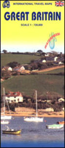
Great Britain ITMB
Great Britain on an indexed, double-sided map from ITMB printed on light, waterproof and tear-resistant synthetic paper. The map divides the country north/south across the southern part of the Lake District, with a small overlap between the sides. Coverage inludes most of Northern Ireland. Topography is shown by altitude colouring with names of main mountain ranges and highlighting for national parks and selected other protected areas. Road network presents the motorways with junction numbers and services, and shows the numbers of most A roads. Many B roads are included but not numbered. Railway lines and ferry connections are included and administrative boundaries are marked. Symbols indicate various places of interest. Latitude and longitude lines are drawn at 1° intervals. Each
side has a separate index.
side has a separate index.

Product Description
Reviews/Comments
Add New
Vouchers
No voucher codes found.
Do you know a voucher code for this product or supplier? Add it to Insights for others to use.
Do you know a voucher code for this product or supplier? Add it to Insights for others to use.
 Denmark