
 United Kingdom
 France
 Germany
 Netherlands
 Sweden
 USA
USA
 Italy
Italy
 Spain
Spain
More From Contributor


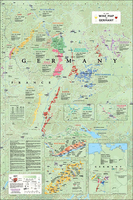
Germany Wine Wall Map
Wine wall map of Germany from De Long Company, size 61 x 92 cm / 24” x 36”, presents in an attractive pastel colouring the country’s officially designated wine growing regions. Rather than covering the whole country, the map shows its south-western part between Lake Constance and Bonn, with two insets presenting wine regions of eastern Germany: Saale - Unstrut south-west of Leipzig, plus Saxony near Dresden and Meissen.The main map covers both sides of the Rhine from Lake Constance and Basel northwards to Bonn, extending eastwards to include the vineyards of Franconia around Würzburg. Coverage also extends across the Rhine and the Moselle to show the wine growing areas of Alsace and Luxembourg. Insets present in greater detail the Rheingau region on the right bank of the Rhine
east of Wiesbaden, plus the central part of the Moselle Valley. The base map has colouring according the mean annual temperature, with graphics to indicate mountainous and/or forested areas, main rivers and roads, plus selected towns and locations within the wine regions. An information panel provides brief descriptions of Germany’s four main classifications: Deutscher Wein, Landwein, Prädikatswien and VDP, plus their subdivisions. Each main region also has a panel showing the area under cultivation and main grape varieties grown there. Map legend and all the text are in English.An interesting feature is the inclusion of latitude lines to provide comparisons with other wine growing areas, e.g. at 49°04 the wine growing region north of Stuttgart is at the latitude of Champagne.
east of Wiesbaden, plus the central part of the Moselle Valley. The base map has colouring according the mean annual temperature, with graphics to indicate mountainous and/or forested areas, main rivers and roads, plus selected towns and locations within the wine regions. An information panel provides brief descriptions of Germany’s four main classifications: Deutscher Wein, Landwein, Prädikatswien and VDP, plus their subdivisions. Each main region also has a panel showing the area under cultivation and main grape varieties grown there. Map legend and all the text are in English.An interesting feature is the inclusion of latitude lines to provide comparisons with other wine growing areas, e.g. at 49°04 the wine growing region north of Stuttgart is at the latitude of Champagne.

Product Description
Reviews/Comments
Add New
Vouchers
No voucher codes found.
Do you know a voucher code for this product or supplier? Add it to Insights for others to use.
Do you know a voucher code for this product or supplier? Add it to Insights for others to use.
 Denmark