
 United Kingdom
 France
 Germany
 Netherlands
 Sweden
 USA
USA
 Italy
Italy
 Spain
Spain
More From Contributor


Germany F&B
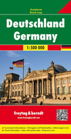
Germany at 1:500, 000 on a large, double-sided road map from Freytag & Berndt, with clear presentation of the road network, plenty of topographic information, and a separate 95-page index booklet listing locations with postcodes. The map shows the country’s road network, clearly distinguishing motorways and main connecting routes from local roads, many of which are shown with driving distances. Motorway interchanges are named and services are marked. Railway lines are included. Topography is indicated by relief shading with plenty of names of geographical features such as mountain and hill ranges, woodlands, regional parks and other protected areas, etc. Small symbols indicate locations of castles and other historical buildings and monuments, but the map is not primarily
designed to show tourist information.Latitude and longitude lines are drawn at 30’ intervals. Multilingual map legend includes English. Extensive index is in a separate booklet attached to the map cover and lists locations with their postcodes.
designed to show tourist information.Latitude and longitude lines are drawn at 30’ intervals. Multilingual map legend includes English. Extensive index is in a separate booklet attached to the map cover and lists locations with their postcodes.

Product Description
Reviews/Comments
Add New
Intelligent Comparison
Archived Product
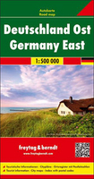
Germany East F&B Stanfords
£10.99
Archived Product
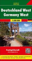
Germany West F&B Stanfords
£10.99
Archived Product
Germany North F&B Stanfords
£10.99
Archived Product
Germany South F&B Stanfords
£10.99
Archived Product
Germany Stanfords
£12.50
Archived Product
Germany Stanfords
£5.99
Archived Product
Germany Stanfords
£13.59
Archived Product
Germany Stanfords
£13.59
Vouchers
No voucher codes found.
Do you know a voucher code for this product or supplier? Add it to Insights for others to use.
Do you know a voucher code for this product or supplier? Add it to Insights for others to use.
 Denmark