
 United Kingdom
 France
 Germany
 Netherlands
 Sweden
 USA
USA
 Italy
Italy
 Spain
Spain
More From Contributor


Florida F&B
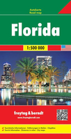
Florida at 1: 500, 000 on a double-sided, indexed road map from Freytag and Berndt with place names in larger print than found on most other maps of the state and icons prominently highlighting various places of interest, plus panels with street plans of central Orlando, Miami Beach and Jacksonville. The map divides the state north - south, with the southern half starting well north of Palm Coast and Daytona Beach, so covering all the Florida’s most visited locations and attractions, but PLEASE NOTE: the way the publishers have marked Disney World makes it very difficult to find it on this map! The map shows the state’s road network with driving distances (in miles) on main routes. County boundaries and names are prominently marked. National/state parks, forests and other
protected areas are highlighted. Large icons indicate numerous places of interest, including campsites. Latitude and longitude lines are drawn at 20’ intervals. Multilingual map legend includes English.Also provided are large panels with street plans of central Orlando, Miami Beach and Jacksonville.
protected areas are highlighted. Large icons indicate numerous places of interest, including campsites. Latitude and longitude lines are drawn at 20’ intervals. Multilingual map legend includes English.Also provided are large panels with street plans of central Orlando, Miami Beach and Jacksonville.

Product Description
Reviews/Comments
Add New
Vouchers
No voucher codes found.
Do you know a voucher code for this product or supplier? Add it to Insights for others to use.
Do you know a voucher code for this product or supplier? Add it to Insights for others to use.
 Denmark