
 United Kingdom
 France
 Germany
 Netherlands
 Sweden
 USA
USA
 Italy
Italy
 Spain
Spain
More From Contributor

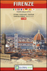
Florence Borch
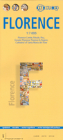
Laminated and waterproof map for visitors to Florence, combining a plan of the city with street plans of Fiésole and central Pisa, a map of the city and its environs, and a road map of most of northern Tuscany. The street plan of Florence at 1:7, 000 extends west to Ponte dellla Vittoria, north to beyond the Firenze EXPO, east to Ponte G. da Verranzzano, and south to the Bobolino district to include the Boboli Gardens. The plan shows one way streets and highlights places of interest, selected accommodation, etc. An inset shows Fiésole at 1:12, 000.On the reverse is a street plan of central Pisa also at 1:7, 000, from the railway station north to the Leaning Tower. A road map at 1:80, 000 covers Florence and its environs, showing access from the A1 motorway and the airport. A
wider part of Tuscany is presented at 1:450, 000, extending over to Lucca, Pisa and the coast, and south to Siena. All the plans and maps are indexed with lists of streets/localities plus main sights and places of interest.Also included are lists of the top 24 sights in Florence and 12 in Pisa, a ground plan of the Duomo, a small map of Italy showing its administrative regions, and information on the city’s climate.
wider part of Tuscany is presented at 1:450, 000, extending over to Lucca, Pisa and the coast, and south to Siena. All the plans and maps are indexed with lists of streets/localities plus main sights and places of interest.Also included are lists of the top 24 sights in Florence and 12 in Pisa, a ground plan of the Duomo, a small map of Italy showing its administrative regions, and information on the city’s climate.

Product Description
Reviews/Comments
Add New
Vouchers
No voucher codes found.
Do you know a voucher code for this product or supplier? Add it to Insights for others to use.
Do you know a voucher code for this product or supplier? Add it to Insights for others to use.
 Denmark