More From Contributor

£9.99
Escape London takes locals & tourists beyond the chaos & noise of London to places of retreat within easy reach of the city. It highlights the destinations that have become iconic escapes, the places that offer adventure, culture & culinary delights, as well as historic attractions & chocolate-box villages. Chapters include the following (together with a few examples for each) Culture & Heritage Hastings, Arundel, Cookham Gardens & Greenery Sissinghurst, Rye, Lewes, Henley-on-Thames Gastronomy & luxury Mersea Isl&, Whitstable, Goodwood, Cowarth Park Family Friendly Chislehurst Caves, Margate, Hampton Court, Great Missenden Cool & Quirky Brighton, Hythe, Southend-on Sea ...
Archived Product
£15.00
This full-colour poster showing the symbols related to escape route signs & equipment location markings as adopted by resolution A.1116 (30). As per resolution A.1111 (30), the signage in this poster should take effect on ships constructed on or after 1 January 2019 or ships which undergo repairs, alterations, modifications & outfitting within the scope of SOLAS chapters II-2 and/or III, as applicable, on or after 1 January 2019. ...
Archived Product
£16.95
New from the publishers of the Cool Camping & Wild Swimming series` comes Escape Routes; a unique cycling guide that`s less about the destination & more about enjoying the journey there
- & back. Matt Carroll maps out 60 unforgettable rides across Engl&, from an easy 5 mile-meander to a 20-mile day trip, with something for every level of cyclist on every kind of bike. Enjoy the rush of freewheeling down a hill with the beautiful English countryside gliding by. Get up close & personal with England`s most gorgeous coastline. When you`re out on your bike you can go where you want, when you want
- all in your own sweet time. Combining inspirational photography, beautiful h&-drawn maps, engaging writing & essential practical information
- including where to hire bicyles en route
- this stunning book will guide you through England`s most breathtaking cycle rides. &, when you`re ready to give your legs a rest, there`s a detailed list of cracking places to eat, drink, & sleep. Hop on to your bike & enjoy the ride.


...
Archived Product
£9.99
Leaving their Welsh hill farm behind, Nick, Ros & their children arrive on the little-known island of Ikaria in 1978, having impulsively boarded the first ferry leaving Athens. Escape to Ikaria tells the story of how they become involved with the islanders & their way of life. Nick tries his hand at anything to get by: night fishing out in the Aegean, unloading the potato boats from Samos, mixing cement for wayward house-builder Datsun Jim, & tending the gardens of the old monastery where a solitary nun, Sister Ulita, controls the village`s water supply. ...
Archived Product
£9.50
Photoluminescent Vinyl
- 100mm x 300mm. Stanfords is an official distributor of Maritime Progress safety signs. We are able to
...
Archived Product
£4.00
Escaping London Pocket Map/ Guide from Curio-City presenting a 13-mile Pre-Raphaelite Pilgrimage Route from London Bridge to William Morris`s Red House in Bexleyheath. On one side the route is highlighted on four panels of street plans, with brief descriptions of various interesting points including the famous George Inn, Greenwich Park, the tomb of Christophe Marlowe in Deptford, etc. Informative text draws one’s attention to many spots often overlooked by passers by. The map also indicates parts of an old medieval pilgrimage route & shows Underground or railway stations & the numbers of local bus lines. The reverse side is full of tips for finding wonderful and/or weird sights elsewhere in London, from Keats House in Hampstead to the stone commemorating the death of German ambassador’s poodle in a fire in 1934. ...
Archived Product
£19.99
Based on many interviews, & hundreds of reference photos, Kugler`s beautifully observed drawings of his interviewees bring to life their location
- a room, a camp, on the road: the stretch of tents on Kos, opposite the stalls selling trinkets to tourists. His reporting of their stories is peppered with snatches of conversation & images of the objects that have become such a significant part of their lives: a toilet roll, the rolling tobacco pouch, the mobile phone. Through Kugler`s complicated, intense graphic reportage, we empathise with those whose experiences he records.
...
Archived Product
£11.50
Eschenbach i.d.OPf. in a series of GPS compatible recreational editions of the Bavarian topographic survey at 1:25, 000, with waymarked hiking trails & cycling routes, campsites & youth hostels, etc. Coverage

Includes::
Creußen, Kirchenthumbach, Speichersdorf, Kemnath, Neustadt am Kulm, Grafenwöhr. Contours used in this map vary between 5 to 20m according to the terrain, with 20m interval predominantly used for hilly areas. Varied colouring show different types of landscape: woods, vineyards, fields etc. Maps in this series feature extensive overprint highlighting local & long-distance footpaths & cycle routes, including King Ludwig Way or different variants of the Way of St James, indicating their waymarking. Symbols highlight different types of accommodation (campsites, youth hostels, refuges, etc), sport & recreational facilities, various places of interest, etc. The maps have a 1-km UTM grid. Map legend & all the text are in German only. To see other titles in this series please click on the series link.

...
Archived Product
£12.99
Escholzmatt, map No. 244, in the standard topographic survey of Switzerland at 1:50, 000 from Swisstopo, i.e. without the special overprint highlighting walking trails, local bus stops, etc, presented in Swisstopo’s hiking editions of the 50K survey. Highly regarded for their superb use of graphic relief & hill shading, the maps give an almost 3-D picture of Switzerland`s mountainous terrain. Contours are at 20m intervals. All the maps have a 1-km grid with the Swiss national coordinates. This standard version of the 50K survey covers the whole country on 78 small format sheets, with special larger format maps published for several popular tourist destinations. Small format sheets cover an area of 35 x 24 km (21 x 15 miles approx) & have map legend in the language of the area covered by the map. The special larger sheets cover 50 x 35 km (31 x 22 miles approx) & have no map legend, but a separate leaflet can be provided instead.PLEASE NOTE: the hiking editions of the 1:50, 000 Swisstopo survey are listed on our website in a separate series. ...
Archived Product
£18.99
Escholzmatt area, map No. 244T, at 1:50, 000 in a special hiking edition of the country’s topographic survey, published by Swisstopo in cooperation with the Swiss Hiking Federation. Cartography, identical to the standard version of the survey, is highly regarded for its superb use of graphic relief & hill shading to provide an almost 3-D picture of Switzerland`s mountainous terrain. Contours are at 20m intervals. An overprint highlights routes maintained by the SHF, distinguishing between hiking routes, mountain routes requiring proper footwear, & alpine routes where equipment is needed. Paths which are part of the national or regional network of long-distance hiking routes are specially marked & in the more recent editions are annotated with their official numbers. The maps show mountain huts, refuges & in remote areas also inns, plus roads with bus service & the positions of bus stops. All the maps have a 1-km grid of the Swiss national coordinates. For a list of all the titles in this series, please click on the series link. ...
Archived Product

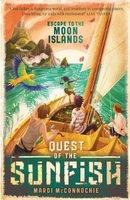
Escape To The Moon Islands: Quest Of The Sunfish 1

When Will and Annalie`s father disappears, they set out on a perilous sea voyage to find him. The motley crew of runaways put their faith in each other, and in a small sailing boat called the Sunfish. In a world transformed by a catastrophic Flood, they embark on an adventure that will test their ingenuity - and their friendship - to the limits.The crew face off against storms and pirates, but the biggest threat of all comes from the Admiralty, the all-powerful navy that rules the oceans of the world. The Admiralty are supposed to be the good guys, but the deeper the Sunfish voyages into the Moon Islands, the more they realise that nothing is what it seems.
RIP - This product is no longer available on our network. It was last seen on 25.09.2019

This page now acts as a permanent archive for this product. Add more information using the comments box below to ensure it can still be found by future generations.

Use our search facility to see if it is available from an alternative contributor.
  • Availability: Out Of Stock
  • Supplier: Stanfords
  • SKU: 9781760630058
Availability: In Stock
£6.99

Product Description

When Will & Annalie`s father disappears, they set out on a perilous sea voyage to find him. The motley crew of runaways put their faith in each other, & in a small sailing boat called the Sunfish. In a world transformed by a catastrophic Flood, they embark on an adventure that will test their ingenuity
- & their friendship
- to the limits. The crew face off against storms & pirates, but the biggest threat of all comes from the Admiralty, the all-powerful navy that rules the oceans of the world. The Admiralty are supposed to be the good guys, but the deeper the Sunfish voyages into the Moon Islands, the more they realise that nothing is what it seems.

Reviews/Comments

Add New

Intelligent Comparison

Oooops!
We couldn't find anything!
Perhaps this product's unique.... Or perhaps we are still looking for comparisons!
Click to bump this page and we'll hurry up.

Price History

Vouchers

No voucher codes found.
Do you know a voucher code for this product or supplier? Add it to Insights for others to use.

Facebook

Jargon Buster

World - A physical grouping, commonly used to describe earth and everything associated with ti
Set - a group of items usually related to one another. Some objects cannot function without the complete set of items.
Small - something that takes up less space than normal.
Adventure - an undertaking of an exciting challenge or experience.
Navy - A dark blue colour, also an armed forces that operates out at sea

Supplier Information

Stanfords
Stanfords was established in 1853 and opened their iconic Covent Garden flagship store in 1901. They have become the top retailer of maps, travel books and accessories in the UK and arguably offer the largest selection of maps and travel books worldwide. Famous names such as Captain Robert Falcon Scott, Ranulph Fiennes and Michael Palin have purchased from Stanfords. They now have a shop in Bristol and both stores together with other venues operate a calendar of events including talks, book signings and exhibitions. As a specialist map retailer, the map selection is comprehensive and includes road maps, street maps and walking maps from worldwide destinations, as well as a selection of world atlases and wall maps. Books include travel guides and travel literature. Stanfords also stock globes, from miniatures made of blue marble to magnificent floor-standing globes. The website features a selection of interesting articles on travel topics.
Page Updated: 2023-11-12 20:15:36

Community Generated Product Tags

Oh No! The productWIKI community hasn't generated any tags for this product yet!
Menu