More From Contributor
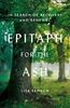
£12.99
Topographic survey of France at 1:25, 000 in IGN`s excellent TOP25 / Série Bleue series. All the maps are GPS compatible, with a 1km UTM grid plus latitude & longitude lines at 5’ intervals. Contours are at 5m intervals except for mountainous areas where the maps have contours at 10m intervals, vividly enhanced by hill shading & graphics for rocky terrain. Colouring with graphics indicates different types of vegetation or land use (deciduous or coniferous forests, moors, orchards, vineyards, etc). PLEASE NOTE: coverage of France at this scale is currently being revised – the format & the presentation of each title are indicated by the letters at the end of its Sheet Reference number (e.g. 0416ET, 3531ETR, 1923SB, etc.)MAPS WITH FULL TOURIST OVERPRINT & AN ENGLISH MAP LEGEND: all TOP25 maps & the SB editions of Série Bleue have an overprint highlighting waymarked walking trails including long-distance GR routes &, where appropriate, ski routes. Symbols indicate campsites, gîtes d’etape, refuges, equestrian centres & other recreational facilities or sites, tourist information centres, cultural heritage, etc. Towns & locations of particular interest are highlighted.- ET or OT = single-sided TOP25 map covering approx. 29x 21 km / 18x 13 miles.- ETR or OTR = waterproof & tear resistant TOP25 map covering the same area as the corresponding ET or OT number, but double-sided, printed on a smaller size sheet with a good overlap between the sides.- SB = Série Bleue map with full tourist overprint; these maps, first introduced in summer 2014, each cover approx. 29x 24km / 18x 15 miles.SÉRIE BLEUE maps with numbers ending in E (Est) or O (Ouest): most editions now indicate the GR routes, but do not show any other tourist information. Map legend is in French only. Each map covers approx. 14x 20km / 9x 12 miles. ...
Archived Product
£8.99
Jerry has a traumatic past that leaves him subject to psychotic hallucinations & depressive episodes. When he stands accused of stealing a priceless Van Gogh painting, he goes underground, where he develops an unwilling relationship with a woman who believes that the voices she hears are from God. Involuntarily entangled in the illicit world of sex-trafficking amongst the Hollywood elite, & on a mission to find redemption for a haunting series of events from the past, Jerry is thrust into a genuinely shocking & outrageously funny quest to uncover the truth & atone for historical sins. A complex, page-turning psychological thriller, riddled with twists & turns, Epiphany Jones is also a superb dark comedy with a powerful emotional core. You`ll laugh when you know you shouldn`t, be moved when you least expect it &, most importantly, never look at Hollywood, celebrity or sex in the same way again. This is an extraordinary debut from a fresh, exceptional new talent. ...
Archived Product
£5.50
Photoluminescent Vinyl
- 150mm x 150mm. Stanfords is an official distributor of Maritime Progress safety signs. We are able to
...
Archived Product
£5.50
Photoluminescent Vinyl
- 150mm x 150mm. Stanfords is an official distributor of Maritime Progress safety signs. We are able to
...
Archived Product
£10.99
Epirus & Western Macedonia at 1:200, 000 in a series of regional road maps of Greece from Terrain Editions, printed on light, waterproof & tear-resistant synthetic paper. The map is double-sided, with a generous overlap between the sides; coverage

Includes::
Corfu, Paxos & Antipaxos, as well as many of the most popular hiking areas of the Pindos mountains. Topography is shown by relief shading with light altitude colouring & plenty of names of mountain ranges. All place names are in both Greek & Latin alphabets. Presentation of the road network differentiates between smooth & rough dirt roads, & shows driving distances on many local roads plus locations of petrol stations. Scenic routes are highlighted. Railway lines & ferry routes are included. A range of symbols indicate various places of interest including campsites & mountain refuges, archaeological sites, churches & monasteries, skiing areas, etc. The map has a 10km UTM grid, with latitude & longitude shown by margin ticks & crosshairs at 10’. Map legend

Includes::
English. The index, separate for the Greek & Latin alphabet place names & with lists of monasteries & archaeological sites, is on the map; unlike in some titles in this series no street plans are included.


...
Archived Product
£12.99
Inspired by her uncle, Lisa Samson has communed with trees since her childhood. Tragically, a disease from mainland Europe now poses a very serious threat to the ash tree`s survival. Epitaph for the Ash explores how barren our landscape could become without the ash`s familiar branches protruding from limestone scars & chalky cliff faces. The trees` grave prognosis takes on a personal resonance when, in the course of writing this book, Lisa is diagnosed with a brain tumour. While she receives treatment, & learns to walk & talk again, Lisa finds solace once more in the natural world. She continues to research her beloved forests, which once sheltered a wealth of flora & fauna, seeking out the possibilities that modern science might provide for their survival. Taking us from the lowlands of Norfolk to northernmost reaches of the British Isles, Lisa`s book is a celebration of the deep cultural & historical significance of the ash. As Lisa contemplates her own mortality, & the trees` likely fate emerges, Epitaph for the Ash offers up a rallying cry to treasure these remarkable woodlands while we still can, before it is too late. ...
Archived Product
£10.99
Limited by the Imperial War Graves Commission to 66 letters
- & that included counting the space between each word as one letter
-

...
Archived Product
£14.99
Epping Forest, Lee Valley, Hertford & Harlow area on a detailed topographic & GPS compatible map No. 174, waterproof version, from the Ordnance Survey’s 1:25, 000 Explorer series.MOBILE DOWNLOADS: this title & all the other OS Explorer maps include a code for downloading after purchase the digital version onto your smartphone or tablet for viewing on the OS smartphone app.OS EXPLORER SERIES: to see the list of all the titles in the OS Explorer series, both paper & waterproof versions, please click on the series link. The Explorer series, Ordnance Survey’s most detailed maps recommended for anyone enjoying outdoor activities, provides topographic coverage of Great Britain at 1:25, 000 on GPS compatible maps with hiking trails, cycling routes & extensive tourist information. Each printed map is available either on paper or as a waterproof & tear-resistant OS Active Map, as indicated in its title. Britain’s National Parks & other areas of particular tourist interest are presented on often double-sided OL (Outdoor Leisure) maps, whilst most standard format Explorers cover an area of 30 x 20km (approx. 19 x 12 miles). All three versions (paper, waterproof & digital) are the same & provide plenty of recreational & tourist information, indicating the traditional public right of way paths (except in Scotland where different laws apply), including bridleways & byways. National Trails & other long-distance paths are marked, as well as permissive footpaths or bridleways & on-road or traffic-free cycle routes with, where appropriate, their National/ Regional Cycle Network numbers. Boundaries of access land are clearly marked. A wide range of symbols provides additional tourist information, highlighting camping & caravanning sites, information offices & visitors’ centres, parking & picnicking places, country pubs, sport & recreational facilities including cycle hire locations & mountain biking trails, historic buildings & museums, etc. Exceptionally clear presentation of the landscape is provided by contours at 5m or in the uplands at 10m intervals, with additional spot heights plus colouring and/or graphics for different types of woodlands, orchards, heath, marshl&, scree or boulders, & other topographic features. For GPS users the maps have British National Grid lines at 1km intervals, with latitude & longitude given by margin ticks at 1`. Clearly laid out map legend

Includes::
French & German translations for the tourist information symbols.

...
Archived Product
£8.99
Epping Forest, Lee Valley, Hertford & Harlow area on a detailed topographic & GPS compatible map No. 174, paper version, from the Ordnance Survey’s 1:25, 000 Explorer series.MOBILE DOWNLOADS: this title & all the other OS Explorer maps include a code for downloading after purchase the digital version onto your smartphone or tablet for viewing on the OS smartphone app.OS EXPLORER SERIES: to see the list of all the titles in the OS Explorer series, both paper & waterproof versions, please click on the series link. The Explorer series, Ordnance Survey’s most detailed maps recommended for anyone enjoying outdoor activities, provides topographic coverage of Great Britain at 1:25, 000 on GPS compatible maps with hiking trails, cycling routes & extensive tourist information. Each printed map is available either on paper or as a waterproof & tear-resistant OS Active Map, as indicated in its title. Britain’s National Parks & other areas of particular tourist interest are presented on often double-sided OL (Outdoor Leisure) maps, whilst most standard format Explorers cover an area of 30 x 20km (approx. 19 x 12 miles). All three versions (paper, waterproof & digital) are the same & provide plenty of recreational & tourist information, indicating the traditional public right of way paths (except in Scotland where different laws apply), including bridleways & byways. National Trails & other long-distance paths are marked, as well as permissive footpaths or bridleways & on-road or traffic-free cycle routes with, where appropriate, their National/ Regional Cycle Network numbers. Boundaries of access land are clearly marked. A wide range of symbols provides additional tourist information, highlighting camping & caravanning sites, information offices & visitors’ centres, parking & picnicking places, country pubs, sport & recreational facilities including cycle hire locations & mountain biking trails, historic buildings & museums, etc. Exceptionally clear presentation of the landscape is provided by contours at 5m or in the uplands at 10m intervals, with additional spot heights plus colouring and/or graphics for different types of woodlands, orchards, heath, marshl&, scree or boulders, & other topographic features. For GPS users the maps have British National Grid lines at 1km intervals, with latitude & longitude given by margin ticks at 1`. Clearly laid out map legend

Includes::
French & German translations for the tourist information symbols.

...
Archived Product
£6.39
A detailed topographic map of Epping Forest & Lee Valley from the Ordnance Survey Explorer series, covering Hertford & Harlow. Edition A3; Publication date April 2009 About this series: These highly detailed maps show all the administrative boundaries, settlements as small as isolated farms, the road network down to unfenced roads & country tracks, & field boundaries (hedges & drystone walls) which make navigation across the countryside much easier. Steep gradients on roads are indicated. Various landmarks, e.g. powerlines, archaeological sites, windmills, churches & lighthouses are shown & additional graphics indicate natural terrain features such as cliffs, scree, mud & vegetation variations. The contour interval is 5 metres in the lower parts of the country & 10 metres in the uplands, & spot heights are marked. Each map covers an area of 30 x 20km (i.e. approx. 19 x 12 miles), with some double-sided maps covering more, as indicated in the individual descriptions. The maps are fully GPS compatible, with the National Grid shown at 1km intervals & latitude & longitude indicated by margin ticks at 1'. The Explorer series has replaced the earlier, green-cover Pathfinder maps. The Explorer series is now complete & covers all of Engl&, Wales & Scotl&. Some sheets for popular areas like the National Parks are still branded as Outdoor Leisure (OL) maps, but are now included in this series as the cartography is the same as that in the Explorer Maps. The Explorer maps offer a substantial improvement on the Pathfinder series, with greater use of colour, larger area per map, & stronger emphasis on information for ramblers & tourists. This series is ideal for walking & other outdoor pursuits & each map shows a large amount of information for ramblers & tourists. Public rights of way are shown (except in Scotland), together with other routes with public access: National Trails & Recreational Paths, permitted paths & bridleways, & selected cycle routes. Open access land created under the Countryside & Rights of Way Act 2000 is marked. Tourist information

Includes::
caravan & campsites, Park & Ride locations, recreation/leisure/sport centres, museums, historic buildings, English Heritage & National Trust sites, rural pubs, etc. The map legend is in English only, except for the tourist information content which is also in French & German.

...
Archived Product

Epitaph For A Spy

Josef Vadassy, a Hungarian refugee and language teacher living in France, is enjoying his first break for years in a small hotel on the Riviera. But when he takes his holiday photographs to be developed at a local chemists, he suddenly finds himself mistaken for a Gestapo agent and a charge of espionage is levelled at him. To prove himself innocent to the French police, he must discover which one of his fellow guests at his pension is the real spy. As he desperately tries to uncover the true culprit`s identity, Vadassy must risk his job, his safety and everything he holds dear.
RIP - This product is no longer available on our network. It was last seen on 25.09.2019

This page now acts as a permanent archive for this product. Add more information using the comments box below to ensure it can still be found by future generations.

Use our search facility to see if it is available from an alternative contributor.
  • Availability: Out Of Stock
  • Supplier: Stanfords
  • SKU: 9780141190310
Availability: In Stock
£9.99

Product Description

Josef Vadassy, a Hungarian refugee & language teacher living in France, is enjoying his first break for years in a small hotel on the Riviera. But when he takes his holiday photographs to be developed at a local chemists, he suddenly finds himself mistaken for a Gestapo agent & a charge of espionage is levelled at him. To prove himself innocent to the French police, he must discover which one of his fellow guests at his pension is the real spy. As he desperately tries to uncover the true culprit`s identity, Vadassy must risk his job, his safety & everything he holds dear.

Reviews/Comments

Add New

Intelligent Comparison

Oooops!
We couldn't find anything!
Perhaps this product's unique.... Or perhaps we are still looking for comparisons!
Click to bump this page and we'll hurry up.

Price History

Vouchers

No voucher codes found.
Do you know a voucher code for this product or supplier? Add it to Insights for others to use.

Facebook

Jargon Buster

Hotel - An establishment which provides lodging for a fee
police - Persons empowered to reduce civil disorder and enforce the law.
France - A state situated in Western Europe with several overseas territories.
Safety - prevents damage being caused.
Language - the method of communication used in different areas. Humans and computers have many different languages.
Small - something that takes up less space than normal.
Language - The way humans communicate either written and spoken.

Supplier Information

Stanfords
Stanfords was established in 1853 and opened their iconic Covent Garden flagship store in 1901. They have become the top retailer of maps, travel books and accessories in the UK and arguably offer the largest selection of maps and travel books worldwide. Famous names such as Captain Robert Falcon Scott, Ranulph Fiennes and Michael Palin have purchased from Stanfords. They now have a shop in Bristol and both stores together with other venues operate a calendar of events including talks, book signings and exhibitions. As a specialist map retailer, the map selection is comprehensive and includes road maps, street maps and walking maps from worldwide destinations, as well as a selection of world atlases and wall maps. Books include travel guides and travel literature. Stanfords also stock globes, from miniatures made of blue marble to magnificent floor-standing globes. The website features a selection of interesting articles on travel topics.
Page Updated: 2023-11-12 20:15:36

Community Generated Product Tags

Oh No! The productWIKI community hasn't generated any tags for this product yet!
Menu