More From Contributor

£10.99
Winner of the Victor Turner Prize for Ethnographic Writing 2017 Journeying around the globe, through past & present, Emma Tarlo unravels the intriguing story of human hair & what it tells us about ourselves & society. When it`s not attached to your head, your very own hair takes on a disconcerting quality. Suddenly, it is strange. & yet hair finds its way into all manner of unexpected places, far from our heads, including cosmetics, clothes, ropes, personal & public collections, & even food. Whether treated as waste or as gift, relic, sacred offering or product in a billion-dollar industry for wigs & hair extensions, hair has many stories to tell. Collected from Hindu temples & Buddhist nunneries & salvaged by the strand from waste heaps & the combs of long-haired women, hair flows into the industry from many sources. Entering this strange world, Emma Tarlo tracks hair`s movement across India, Myanmar, China, Africa, the United States, Britain & Europe, meeting people whose livelihoods depend on this singular commodity. Whether its journey ends in an Afro hair fair, a Jewish wig parlour, fashion salon or hair loss clinic, hair is oddly revealing of the lives it touches. ...
Archived Product
£19.99
Entlebuch
- Emmental area at 1:50, 000 in a series of waterproof & tear-resistant, contoured mountain biking maps from Hallwag,
...
Archived Product
£20.99
Entlebuch
- Pilatus
- Engelberg area, map No. 5023, in the standard topographic survey of Switzerland at 1:50, 000 from Swisstopo,

...
Archived Product
£6.50
Topographic coverage of mainland Spain at 1:25, 000 published by the Centro Nacional de Información Geograficá, the country’s civilian survey organization. The maps have contours at 10m intervals & colouring and/or graphics to show different types of vegetation or land use. Boundaries of national parks & other protected areas are marked. In addition to all the usual information shown on topographic maps at this scale, detailed presentation of the road & rail networks, rural tracks & paths, etc, the maps also show campsites. The maps have a 1-km UTM grid, with margin ticks for latitude & longitude at 1` intervals. Map legend is in Spanish only.PLEASE NOTE: our grid for the whole of Spain is in preparation
- in the meantime, for areas other than those shown on the attached grid please use CNIG’s topographic survey at 1:50, 000 by searching for ‘SI00000832’. Each 25K map covers one quarter of the corresponding 50K map, with the numbering system: I = NW quarter, II = NE quarter, III = SW quarter & IV = SE quarter. CNIG maps in the Provincial Road Maps series at 1:200, 000 are overprinted with the grid for the 1:50, 000 survey & can be used to see the area covered by each 50K or 25K title in more detail. To see the list of titles in this series please click on the series grid
- for map numbers not yet listed on our website please contact us by email.

...
Archived Product
£12.99
Stalinism, that particularly brutal phase of communism, came to an end in most of Eastern Europe with the death of Josef Stalin in 1953 or at least with the Khrushchev reforms that began in the Soviet Union in 1956. However, in one country
- Albania
- Stalinism survived virtually unscathed until 1990. The regime that the Albanian dictator Enver Hoxha led from the time of the communist takeover in 1944 until his death in 1985, & that continued unabated under his successor Ramiz Alia until 1990, was incomparably severe. Such was the reign of terror that no audible voice of opposition or dissent ever arose in the Balkan state, a European country that became as isolated from the rest of the world as North Korea is today. When the Albanian communist system finally imploded, it left behind a weary population, frightened & confused after decades of purges & political terror. It also left behind a country with a weak & fragile economy, a country where extreme poverty was the norm. In the decades since Hoxha`s death, Albania has made substantial progress in political & economic terms, yet the spectre of Hoxha still lingers over the country. Despite this, many people
- inside & outside Albania
- know little about the man who ruled the country with an iron fist for so many decades. This book provides the first biography of Enver Hoxha available in English, from his birth in Gjirokast Er in southern Albania, then still under Ottoman rule, to his death in 1985 at the age of 76. Using archival documents & first-hand interviews, Albanian journalist Blendi Fevziu pieces together the life of this tyrannical ruler, in a biography which will be essential reading for anyone interested in Balkan history & communist studies.


...
Archived Product
£20.50
Les Environs de Gap à pied, FFRP topo-guide ref. no. P051, one of the titles in an extensive series of light, A5-size, high quality paperback guides published by the Fédération Française de la Randonnée Pédestre in association with local authorities, ramblers’ clubs, etc. The guides have *colour extracts from the French topographic survey at 1:25, 000 or 1:50, 000 overprinted with local hiking routes*. Each guide offers a selection of day walks of different length & difficulty of terrain, all clearly graded. * Several titles also include a section of a long-distance GR route or a shorter GRP (GR de Pays) route or circuit.* The descriptions provide information on various places of interest along the routes & directions for special points marked on the accompanying maps. * All the text is in French*, but there is also a fair amount of information conveyed by symbols: waymarking, parking facilities, villages with local shops, cafes & restaurants, etc. Most guides have numerous colour photos & drawings of local flora & fauna. Guides with day walks are indicated on the accompanying series grid by yellow, blue or green boxes.* In this guide:* 46 day walks fro one & a half to seven hours long, mainly north of Gap. ...
Archived Product
£20.50
Environs de Lyon à pied, FFRP Topo-guide No. RE20, with 41 day walks of varying length & difficulty all accessible within a 60min journey from Lyon on the regional train network (TER). Current edition of this title was published in March 2016. To see the list of other FFRP guides with day walks please click on the series link.ABOUT THE FFRP (Fédération française de la randonnée pédestre) TOPOGUIDES: published in a handy A5 paperback format, the guides are the best companions for hiking in France. In addition to their topo-guides to the long-distance GR routes FFRP also publish an extensive range of guides with local day walks. Each walk in presented on a colour extract from IGN`s 1:50, 000 or 1:25, 000 topographic survey mapping overprinted with the route, with important points cross-referenced to the accompanying text, in French only, placed on the adjoining page. For each walk the guides also indicate the degree of difficulty & provide information on length, time & change in altitude, waymarking signs, access by road & parking facilities. An “info practiques” section of the guide indicates where shops, restaurants & accommodation can be found. The guides are published on high quality paper & include descriptions of the most interesting aspects of the surrounding region: historical & cultural sites, local specialties, fauna & flora, etc, all illustrated with colour photos. ...
Archived Product
£15.99
The environs of Hamburg Cycling Atlas at 1:75, 000 in a series of handy size spiral bound atlases from Verlag Esterbauer, Europe’s leading publishers of cycling maps. Cycling atlases from Verlag Esterbauer have a map legend which

Includes::
English &, although ALL THE TEXT IN THESE GUIDES IS IN GERMAN ONLY, information provided on the maps is sufficient to use them without any knowledge of German, particularly in the absence of similar products in English from other publishers. Please click on our sample image to see an extract from the map legend. Each atlas

Includes::
a selection of local cycling routes & tours, presented on clear, easy to follow maps. The overprint highlighting the routes indicates road surface & density of motorized traffic. Gradients, intermediate distances, danger points, & roads closed to cyclists are marked & route profiles show the degree of difficulty for each cycle path. A wide range of symbols indicate everything from covered & lockable bicycle stands, repair workshops & bike rentals to viewpoints, nature parks, leisure & sport centres, local shopping facilities, emergency services, etc. The guides also give opening hours of museums & other local places of interest. A separate section at the end of each guide list accommodation addresses with phone numbers. To see other titles in this series please click on the series link.


...
Archived Product
£5.99
The MICHELIN zoom map Environs of Parisis the ideal travel companion to fully explore Paris & its surrounding areas, thanks to its easy-to-use format & its scale of 1/100, 000.

Includes::
Senlis, Compiegne, Fontainbleau, Chartres, Vernon The Zoom collection are characterized by the high precision of their detailed scale, specially adapted for very touristy areas or with a high density road network, including new developments & industrial areas. In addition to clarity, reliability & up-to-date information, all Michelin cartography features include a wealth of practical information: places & monuments of tourist interest, picturesque tours, areas for sports & leisure activities... Useful plans of cities & a practical index of localities. Also the maps contain places of interest & signposting of tracks for bicycles & greenways.

...
Archived Product
£14.99
Environs of Stuttgart Cycling Atlas in a series of handy size spiral bound atlases from Verlag Esterbauer, Europe’s leading publishers of cycling maps. The atlas covers cycling routes in the environs of the city, including the northern part of the Black Forest. Cycling atlases from Verlag Esterbauer have a map legend which

Includes::
English &, although ALL THE TEXT IN THESE GUIDES IS IN GERMAN ONLY, information provided on the maps is sufficient to use them without any knowledge of German, particularly in the absence of similar products in English from other publishers. Please click on our sample image to see an extract from the map legend. Each atlas

Includes::
a selection of local cycling routes & tours, presented on clear, easy to follow maps. The overprint highlighting the routes indicates road surface & density of motorized traffic. Gradients, intermediate distances, danger points, & roads closed to cyclists are marked & route profiles show the degree of difficulty for each cycle path. A wide range of symbols indicate everything from covered & lockable bicycle stands, repair workshops & bike rentals to viewpoints, nature parks, leisure & sport centres, local shopping facilities, emergency services, etc. The guides also give opening hours of museums & other local places of interest. A separate section at the end of each guide list accommodation addresses with phone numbers. To see other titles in this series please click on the series link.


...
Archived Product

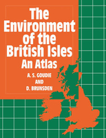
Environment Of The British Isles Atlas

In this atlas the authors have brought together, in accessible form, a set of maps which portray a vivid picture of the physical environment of the British Isles. Each set of maps is accompanied by text that explains the nature and causes of the patterns that can be observed. The contents are broadly based, covering the geology, geomorphology, hydrology, climatolgoy, soils, biogeography, and seas of the British Isles and the human impact on each of these aspects. The maps are as uncomplicated as the subject matter allows and the text is designed to be accessible to a wide range of readers. The book was prepared to celebrate the centenary of the Geographical Assocation. From it emerges a remarkable picture of the physical landscape. Together with its companion volume, Britiain in
the 1990s: A Social and Economic Atlas, it provides a comprehensive overview of the British Isles.
RIP - This product is no longer available on our network. It was last seen on 25.09.2019

This page now acts as a permanent archive for this product. Add more information using the comments box below to ensure it can still be found by future generations.

Use our search facility to see if it is available from an alternative contributor.
  • Availability: Out Of Stock
  • Supplier: Stanfords
  • SKU: 9780198741732
Availability: In Stock
£19.99

Product Description

In this atlas the authors have brought together, in accessible form, a set of maps which portray a vivid picture of the physical environment of the British Isles. Each set of maps is accompanied by text that explains the nature & causes of the patterns that can be observed. The contents are broadly based, covering the geology, geomorphology, hydrology, climatolgoy, soils, biogeography, & seas of the British Isles & the human impact on each of these aspects. The maps are as uncomplicated as the subject matter allows & the text is designed to be accessible to a wide range of readers. The book was prepared to celebrate the centenary of the Geographical Assocation. From it emerges a remarkable picture of the physical landscape. Together with its companion volume, Britiain in the 1990s: A Social & Economic Atlas, it provides a comprehensive overview of the British Isles.

Reviews/Comments

Add New

Intelligent Comparison

Oooops!
We couldn't find anything!
Perhaps this product's unique.... Or perhaps we are still looking for comparisons!
Click to bump this page and we'll hurry up.

Price History

Vouchers

No voucher codes found.
Do you know a voucher code for this product or supplier? Add it to Insights for others to use.

Facebook

Jargon Buster

Physical - Used to describe strength or visual properties of an item
Human - A highly developed and adapted mamal and deminant species on earth
Set - a group of items usually related to one another. Some objects cannot function without the complete set of items.
Wide - Something with a large width.
Environment - The conditions and surrounding area.

Supplier Information

Stanfords
Stanfords was established in 1853 and opened their iconic Covent Garden flagship store in 1901. They have become the top retailer of maps, travel books and accessories in the UK and arguably offer the largest selection of maps and travel books worldwide. Famous names such as Captain Robert Falcon Scott, Ranulph Fiennes and Michael Palin have purchased from Stanfords. They now have a shop in Bristol and both stores together with other venues operate a calendar of events including talks, book signings and exhibitions. As a specialist map retailer, the map selection is comprehensive and includes road maps, street maps and walking maps from worldwide destinations, as well as a selection of world atlases and wall maps. Books include travel guides and travel literature. Stanfords also stock globes, from miniatures made of blue marble to magnificent floor-standing globes. The website features a selection of interesting articles on travel topics.
Page Updated: 2023-11-12 20:15:36

Community Generated Product Tags

Oh No! The productWIKI community hasn't generated any tags for this product yet!
Menu