
 United Kingdom
 France
 Germany
 Netherlands
 Sweden
 USA
USA
 Italy
Italy
 Spain
Spain
More From Contributor


Ecrins Rando Editions
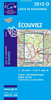
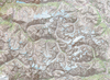
Massif des Ecrins at 1:50, 000 in a series of hiking maps from Rando Editions, with tourist information on a topographic base from the Institut Géographique National. Finely detailed cartography has contours at 20m intervals with relief-shading. Glaciers, cliffs, scree and wooded areas are shown, as well as springs, intermittent streams, etc. Local footpaths and the long-distance GR routes are highlighted and indicate whether signposted, difficult passages, ice hiking trails, and high mountain routes. Symbols highlight mountain huts, refuges and shelters, gîtes d’etape, campsites, numerous leisure and sport centres, places of interest, etc. Ski lifts indicate those open in summer. Boundaries of national parks and other protected areas are marked. The maps have a 2km UTM
grid. Map legend includes English.
grid. Map legend includes English.

Product Description
Reviews/Comments
Add New
Vouchers
No voucher codes found.
Do you know a voucher code for this product or supplier? Add it to Insights for others to use.
Do you know a voucher code for this product or supplier? Add it to Insights for others to use.
 Denmark