
 United Kingdom
 France
 Germany
 Netherlands
 Sweden
 USA
USA
 Italy
Italy
 Spain
Spain
More From Contributor


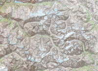
Ecrins Massif Wall Map
Massif des Ecrins presented at 1:25, 000 on an encapsulated waterproof wall map, size 100 x 132cm (39.5” x 52” approx), with cartography of IGN’s excellent TOP25 series. The map combines most of TOP25 maps 3336ET and 3436ET, with coverage extending from the Lac du Chambon, La Grave and Col du Lautaret in the north to the Refuge du Clot and Puy-St-Vincent in the south, and from west of les Deux Alpes and Vénosc eastwards to le Monêtier-les-Bains. The base map and the overprint highlighting hiking and ski trails, campsites and refuges, etc, is the same as in the corresponding TOP25 maps. As on the TOP25 maps, the Tour de l’Oisans (GR 54) is marked but not the whole course of it is included in this title.LAMINATED and ENCAPSULATED WALL MAPS:- LAMINATED wall maps have a thin
layer of plastic usually applied to the printed side only. They can be written on with suitable marker pens without any damage to the map but, unless laminated on both sides, they are not damp-proof.- ENCAPSULATED wall maps are sealed between two sheets of plastic. They are more rigid and heavier than laminated maps of the same size. They are damp-proof and do not crinkle in humid conditions. Encapsulation gives the map a shiny surface, similar to being displayed behind glass.- PLEASE NOTE: many publishers and retailers often use these two terms interchangeably. Our map titles and descriptions follow the definitions provided above.
layer of plastic usually applied to the printed side only. They can be written on with suitable marker pens without any damage to the map but, unless laminated on both sides, they are not damp-proof.- ENCAPSULATED wall maps are sealed between two sheets of plastic. They are more rigid and heavier than laminated maps of the same size. They are damp-proof and do not crinkle in humid conditions. Encapsulation gives the map a shiny surface, similar to being displayed behind glass.- PLEASE NOTE: many publishers and retailers often use these two terms interchangeably. Our map titles and descriptions follow the definitions provided above.

Product Description
Reviews/Comments
Add New
Vouchers
No voucher codes found.
Do you know a voucher code for this product or supplier? Add it to Insights for others to use.
Do you know a voucher code for this product or supplier? Add it to Insights for others to use.
 Denmark