More From Contributor

£8.99
D-Day, 6 June 1944, the turning point of the Second World War, was a victory of arms. But it was also a triumph for a different kind of operation: one of deceit... At the heart of the deception was the ` Double Cross System`, a team of double agents whose bravery, treachery, greed & inspiration succeeded in convincing the Nazis that Calais & Norway, not Normandy, were the targets of the 150, 000-strong Allied invasion force. These were not conventional warriors, but their masterpiece of deceit saved thousands of lives. Their codenames were Bronx, Brutus, Treasure, Tricycle & Garbo. This is their story. ...
Archived Product
£12.99
Get ready, Book 11 in the phenomenally bestselling Diary of a Wimpy Kid series is coming! The pressure`s really piling up on Greg Heffley. His mom thinks video games are turning his brain to mush, so she wants her son to put down the controller & explore his `creative side`. As if that`s not scary enough, Halloween`s just around the corner & the frights are coming at Greg from every angle. When Greg discovers a bag of gummy worms, it sparks an idea. Can he get his mom off his back by making a movie.. .and will he become rich & famous in the process? Or will doubling down on this plan just double Greg`s troubles? ...
Archived Product
£6.99
Walter Huff is an insurance investigator like any other
- until the day he meets the beautiful & dangerous Phyllis Nirdlinger &
...
Archived Product
£24.95
Double Take presents thirty-nine uncannily accurate reconstructions of the great images & moments from history – ranging from the earliest known photograph, through the landmark events of the 20th & 21st century, the icons of popular culture & the art world, to the world’s most expensive photograph. These intricately crafted works have been created in miniature by photographers Jojakim Cortis & Adrian Sonderegger. Inspired by the record auction price of $4.3m set by Andreas Gursky’s Rhein II in 2011, they set themselves a challenge: could they use model making & lighting skills to reconstruct the Gursky image in their Zürich studio? The photograph they created from a miniaturized diorama of Rhein II was a success. It worked! This one-off challenge became the starting point for a larger personal project by the duo – a whole series of increasingly elaborate & difficult recreations of photographs of pivotal events throughout history. The whole world, & the surface of the moon, were conjured in their studio. Double Take is not just a technical tour de force – it opens up a wider consideration of image making, of the ‘slideshow’ of famous photographs we each hold in our memory, & of the problem at the heart of the medium: can the photographic image ever be trusted? With a full selection of images showing the making of the reconstructions in the studio, an introduction by Christian Caujolle, a supporting essay by Florian Ebner (of the Pompidou Centre) & an in-depth interview with the photographers, Double Take is the perfect volume for all with a love of photography with a twist & a sense of humour. ...
Archived Product
£14.99
Doubling Back is a fascinating & moving account of walking in the footsteps of others. In 1952 Linda Cracknell`s father embarked on a hike through the Swiss Alps. Fifty years later Linda retraces that fateful journey, following the trail of the man she barely knew. This collection of walking tales takes its theme from that pilgrimage. The walks trace the contours of history, following writers, relations & retreading ways across mountains, valleys & coasts formerly trodden by drovers, saints & adventurers. Each walk is about the reaffirming of memories, beliefs & emotions, & especially of the connection that one can have with the past through particular places. This book celebrates life, family, friendship & walking through landscapes richly textured with stories. Doubling Back is a masterwork of travel writing in the vein of Robert Macfarlane & Roger Deakin, lyrical, poignant, & with stunning descriptions of the landscapes Linda Cracknell leads us through. ...
Archived Product
£5.99
The départments of Doubs & Jura in Franche-Comté at 1:150, 000 in Michelin’s Local Series, with highlighting for scenic routes, an index, a special panel with best sights & recommended driving tours, & street plans of central Besançon & Lons-le-Saunier. Coverage extends from Vesoul & Belfort southwards to just north of Annecy & eastwards from Dole to include the Swiss part of the Jura Mountains with Neuchâtel & Lausanne. PLEASE NOTE: our coverage image, provided by the publishers, does not take into account which areas along the edge of the map are blocked by the index & the additional features – coverage shown in the north-western & south-eastern corners of the image are not included. Maps in Michelin’s Local Series of France have the same cartography (road network & place names shown on the maps) as the publishers’ Regional Series at 1;200, 000 but enlarged here to 1:150, 000 to provide greater clarity & larger, easier to read print size. Road network is presented in great detail, indicating width, motorway services & rest areas, dangerous or restricted entry roads, steep gradients, height & weight restrictions, etc. Scenic sections are highlighted. The maps also show selected cycle paths & nature trails. Railway lines are shown with stations & local airports are marked. Symbols indicate various places of interest, with additional star rating for best sights, based on the publishers’ Green Guides for French regions. Satellite-derived base with colouring for the forested areas & boundaries of national or regional parks shows the topography. In the mountainous regions the maps have bold, very effective relief shading, with a large number of names of peaks, passes, & other topographic features. The maps have latitude & longitude lines at 10’ intervals & are indexed. Map legend

Includes::
English. Each title in addition

Includes::
a panel showing the area’s principal roads & places of interest, plus recommendations for sightseeing tours. Also provided are town centre maps of main cities, indicating principal traffic arteries, one way streets & places of interest. Only selected streets are named & listed in the accompanying index. Please click on the series link to see all the titles in this series.


...
Archived Product
£6.99
” Yum” said the ogre, lifting George up, ”I`ll have you for dinner tonight.” ” Don`t eat me, ” cried George, ” Have these buns instead! ` Cause I`m seeking a dragon to fight.” George, a young explorer, longs to be a dragon-searching hero from long, long ago. So he climbs in his time machine with only a scooter, some cakes & tasty doughnuts to aid him in his quest. When he arrives in long, long ago he spies a dragon straight away! Or does he? Doughnuts for a Dragon is a funny adventure story, the perfect rhyming picture book read for boy & girls. It`s a fast-paced, rhyming story about princesses, witches, dragons & George
- an intrepid kid determined to time travel & see a dragon. This is a wonderful third installment in the award nominated George`s Amazing Adventures series, this is a funny medieval tale about a dastardly dragon & delicious doughnuts. George`s earlier adventure Spaghetti with the Yeti was nominated for the Roald Dahl Funny Prize 2013, Oscar`s First Book Prize, the Sheffield Book Award & the Portsmouth Book Award.
...
Archived Product
£3.50
Douglas in 1866 in a fascinating series of reproductions of old Ordnance Survey plans in the Alan Godfrey Editions, ideal for anyone interested in the history of their neighbourhood or family. The map is double-sided. The main map the northern half of the town, stretching from Finch Road northward to Falcon Cliff. Features include St Thomas church, Villa Marina Hotel, Woodville area, Woodbourne Square area, Castle Mona Hotel, Castlehill Brewery, House of Industry, baths, etc. On the reverse is the adjacent sheet 13.12, covering the area to the south, stretching from Drumgold Street southward to Fiddler`s Green, & eastward to Douglas Point. Features include the Harbour, New Pier, lighthouse, Purt Skilleig, Harold Tower, St George`s church, The Lake, South Quay Foundry, Market Place, Pollock Rocks, St Matthew`s church, Slack Indigo etc. About the Alan Godfrey Editions of the 25” OS Series: Selected towns in Great Britain & Ireland are covered by maps showing the extent of urban development in the last decades of the 19th & early 20th century. The plans have been taken from the Ordnance Survey mapping & reprinted at about 15 inches to one mile (1:4, 340). On the reverse most maps have historical notes & many also include extracts from contemporary directories. Most maps cover about one mile (1.6kms) north/south, one & a half miles (2.4kms) across; adjoining sheets can be combined to provide wider coverage.FOR MORE INFORMATION & A COMPLETE LIST OF ALL AVAILABLE TITLES PLEASE CLICK ON THE SERIES LINK. ...
Archived Product
£12.99
Topographic survey of France at 1:25, 000 in IGN`s excellent TOP25 / Série Bleue series. All the maps are GPS compatible, with a 1km UTM grid plus latitude & longitude lines at 5’ intervals. Contours are at 5m intervals except for mountainous areas where the maps have contours at 10m intervals, vividly enhanced by hill shading & graphics for rocky terrain. Colouring with graphics indicates different types of vegetation or land use (deciduous or coniferous forests, moors, orchards, vineyards, etc). PLEASE NOTE: coverage of France at this scale is currently being revised – the format & the presentation of each title are indicated by the letters at the end of its Sheet Reference number (e.g. 0416ET, 3531ETR, 1923SB, etc.)MAPS WITH FULL TOURIST OVERPRINT & AN ENGLISH MAP LEGEND: all TOP25 maps & the SB editions of Série Bleue have an overprint highlighting waymarked walking trails including long-distance GR routes &, where appropriate, ski routes. Symbols indicate campsites, gîtes d’etape, refuges, equestrian centres & other recreational facilities or sites, tourist information centres, cultural heritage, etc. Towns & locations of particular interest are highlighted.- ET or OT = single-sided TOP25 map covering approx. 29x 21 km / 18x 13 miles.- ETR or OTR = waterproof & tear resistant TOP25 map covering the same area as the corresponding ET or OT number, but double-sided, printed on a smaller size sheet with a good overlap between the sides.- SB = Série Bleue map with full tourist overprint; these maps, first introduced in summer 2014, each cover approx. 29x 24km / 18x 15 miles.SÉRIE BLEUE maps with numbers ending in E (Est) or O (Ouest): most editions now indicate the GR routes, but do not show any other tourist information. Map legend is in French only. Each map covers approx. 14x 20km / 9x 12 miles. ...
Archived Product

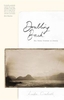
Doubling Back: Ten Paths Trodden In Memory

Doubling Back is a fascinating and moving account of walking in the footsteps of others. In 1952 Linda Cracknell`s father embarked on a hike through the Swiss Alps. Fifty years later Linda retraces that fateful journey, following the trail of the man she barely knew. This collection of walking tales takes its theme from that pilgrimage. The walks trace the contours of history, following writers, relations and retreading ways across mountains, valleys and coasts formerly trodden by drovers, saints and adventurers. Each walk is about the reaffirming of memories, beliefs and emotions, and especially of the connection that one can have with the past through particular places. This book celebrates life, family, friendship and walking through landscapes richly textured with stories.
Doubling Back is a masterwork of travel writing in the vein of Robert Macfarlane and Roger Deakin, lyrical, poignant, and with stunning descriptions of the landscapes Linda Cracknell leads us through.
RIP - This product is no longer available on our network. It was last seen on 25.09.2019

This page now acts as a permanent archive for this product. Add more information using the comments box below to ensure it can still be found by future generations.

Use our search facility to see if it is available from an alternative contributor.
  • Availability: Out Of Stock
  • Supplier: Stanfords
  • SKU: 9781910449301
Availability: In Stock
£8.99

Product Description

Doubling Back is a fascinating & moving account of walking in the footsteps of others. In 1952 Linda Cracknell`s father embarked on a hike through the Swiss Alps. Fifty years later Linda retraces that fateful journey, following the trail of the man she barely knew. This collection of walking tales takes its theme from that pilgrimage. The walks trace the contours of history, following writers, relations & retreading ways across mountains, valleys & coasts formerly trodden by drovers, saints & adventurers. Each walk is about the reaffirming of memories, beliefs & emotions, & especially of the connection that one can have with the past through particular places. This book celebrates life, family, friendship & walking through landscapes richly textured with stories. Doubling Back is a masterwork of travel writing in the vein of Robert Macfarlane & Roger Deakin, lyrical, poignant, & with stunning descriptions of the landscapes Linda Cracknell leads us through.

Reviews/Comments

Add New

Intelligent Comparison

Oooops!
We couldn't find anything!
Perhaps this product's unique.... Or perhaps we are still looking for comparisons!
Click to bump this page and we'll hurry up.

Price History

Vouchers

No voucher codes found.
Do you know a voucher code for this product or supplier? Add it to Insights for others to use.

Facebook

Jargon Buster

swiss - Short for Switzerland, one of the richest countries in the world
History - Anything that happens in the past. An acedemic subject.
Memory - A way to describe the way in which the brain can remember things.
Family - A group of people that live together made up from parents and children.

Supplier Information

Stanfords
Stanfords was established in 1853 and opened their iconic Covent Garden flagship store in 1901. They have become the top retailer of maps, travel books and accessories in the UK and arguably offer the largest selection of maps and travel books worldwide. Famous names such as Captain Robert Falcon Scott, Ranulph Fiennes and Michael Palin have purchased from Stanfords. They now have a shop in Bristol and both stores together with other venues operate a calendar of events including talks, book signings and exhibitions. As a specialist map retailer, the map selection is comprehensive and includes road maps, street maps and walking maps from worldwide destinations, as well as a selection of world atlases and wall maps. Books include travel guides and travel literature. Stanfords also stock globes, from miniatures made of blue marble to magnificent floor-standing globes. The website features a selection of interesting articles on travel topics.
Page Updated: 2023-11-12 20:15:36

Community Generated Product Tags

Oh No! The productWIKI community hasn't generated any tags for this product yet!
Menu