More From Contributor

£5.99
Devon & Cornwall in the Great Breaks mini series from Insight Guides is a slim, focussed short break guide to the counties, whether you are aiming for a relaxing or active break, illustrated with vivid colour photographs & containing easy to navigate information. A top 10 sites for the destinations & their surrounding areas are given, with a selection of detailed & mapped tour/walk ideas, special features on the uniqueness of the locations e.g. their heritage, festivals & wildlife, as well as practical information on active pursuits, themed holidays, & selected places to stay to suit a cross section of budgets & tastes. An overview map showing selected tour routes & a selection of five summary boxes of top five great things to do or places to do adorn the inside jackets. ...
Archived Product
£6.99
Devon & Cornwall in the Great Breaks mini series from Insight Guides is a slim, focussed short break guide to the counties, whether you are aiming for a relaxing or active break, illustrated with vivid colour photographs & containing easy to navigate information. A top 10 sites for the destinations & their surrounding areas are given, with a selection of detailed & mapped tour/walk ideas, special features on the uniqueness of the locations e.g. their heritage, festivals & wildlife, as well as practical information on active pursuits, themed holidays, & selected places to stay to suit a cross section of budgets & tastes. An overview map showing selected tour routes & a selection of five summary boxes of top five great things to do or places to do adorn the inside jackets. ...
Archived Product
£7.99
Marco Polo Pocket Guide Devon & Cornwall: the Travel Guide with Insider Tips. Explore Devon & Cornwall with this handy, pocket-sized, authoritative guide, packed with Insider Tips. Discover boutique hotels, authentic restaurants, the region`s trendiest places, & get tips on shopping & what to do on a limited budget. There are plenty of ideas for travel with kids, & a summary of all the festivals & events that take place. Let Marco Polo show you all this wonderful corner of Britain has to offer... Bright green meadows, wild & remote moors, dramatic coastlines, beautiful harbours, magnificent manor houses, ancient castles & glorious gardens
- Devon & Cornwall are two of the most picturesque counties in Britain. Combine this with the trailblazing food scene, world-class surfing & the world`s largest rainforest in captivity & you`ve got a holiday that is hard to beat. This is Devon & Cornwall! Your Marco Polo Devon & Cornwall Pocket Guide
Includes:: Insider Tips
- we show you the hidden gems & little known secrets that offer a real insight into the region from sampling decadent cream teas with stunning views, unusual nights staying in a lighthouse to enjoying a bike ride along the spectacular Granite Way with views across Dartmoor. Best of
- find the best things to do for free, the best `only in` Devon & Cornwall experiences, the best things to do if it rains & the best places to relax & spoil yourself. Sightseeing
- all of the top sights are organised by areas of the region so you can easily plan your trip. Discovery Tours
- 4 specially tailored walking & driving tours that will help you enjoy all of Devon & Cornwall. Here are inspirational itineraries to help you explore the beautiful coastline, magnificent gardens & literary history. Devon & Cornwall in full-colour
- Marco Polo Pocket Guide Devon & Cornwall

Includes::
full-colour photos throughout the guide bringing the region to life offering you a real taste of what you can see & enjoy on your trip. Touring App
- you can download any of the Discovery Tours to your smartphone, complete with the detailed route description & map exactly as featured in the guide, free of charge. The maps can be used offline too, so no roaming charges. The perfect navigational tool with distance indicators & landmarks highlighting the correct direction to walk in as well as GPS coordinates along the way. Enjoy stress-free sightseeing & never get lost again! Road Atlas & pull-out map
- we`ve included a detailed road atlas & a handy, pull-out map so you can pop the guide in your bag for a full-on sightseeing day or head out with just the map to enjoy your Discovery Tour. Trust Marco Polo Pocket Guide Devon & Cornwall to show you around these fabulous counties. The comprehensive coverage & unique insights will ensure you experience everything Devon & Cornwall has to offer & more. The special tips, personal insights & unusual experiences will help you make the most of your trip
- just arrive & enjoy.


...
Archived Product
£6.99
Regional wall map of > at 1:200, 000 (3.2 miles to 1inch) from A to Z, covering: Weston-super-Mare, Bridgwater, Bridport, Lyme Regis, Exmouth, Exeter, Torquay, Salcombe, Plymouth, Penzance, Land's End, Newquay & Minehead.. Clear presentation of the road network shows motorways, A & B roads, some minor & local roads, with gradients of 1:5 & steeper indicated. Service stations, railway lines & stops, ferry terminals, & airports are clearly marked. Tourist information such as points of interest & local facilities are prominently highlighted with a variety of symbols. Topography is shown by altitude tints, if in rather broad bands, with spot heights (in feet) & additional colouring for woodland areas; the National Grid is overprinted on the cartography. National & unitary authority boundaries are indicated. There is an index for cities, town, & villages at the edge of the map. ...
Archived Product
£3.99
Devon & west Somerset at 1:130, 000 on the Ordnance Survey Tour Map No. 5. Insets show town navigation maps of Plymouth, Bideford, Barnstaple, Ilfracombe, Minehead, Taunton, Tiverton, Exeter, Sidmouth, Newton Abbot, Torquay
- Torbay
- Paignton, Totnes & Brixham, plus the island of Lundy & an overview of the whole area with cycle routes & national hiking trails. Additional topographic information along the coast shows s&, dunes, foreshore & high water mark. Also included are lists of selected places of interest, market days & farmer markets, plus brief notes on the Jurassic Coast World Heritage Site. Edition F; Publication date June 2010 About this series: Ordnance Survey

...
Archived Product
£25.00
We are able to source a wide range of courtesy flags. Flags are available in many sizes & can be sewn or printed on 100% Ministry Of Defence Standard Woven & Knitted Polyester. Flags are supplied with rope & toggle. If you would like more information, have a custom size request or cannot find a desired product, please email us at maritime@stanfords.co.uk. We will be glad to help! ...
Archived Product
£36.95
Military topographic survey mapping with contours. These maps are designed primarily as flying charts for aircraft, but they are useful as general topographical maps where nothing else is available. Contours are shown in feet, with elevation colouring & spot heights. Towns, villages, major roads, railways & airports are shown (but please note that many of the smaller settlements are not named, & the road information is not necessarily up to date). Some air navigation information also appears on the map, such as radio beacons & restricted flying zones. Double-sided sheet. ...
Archived Product
£9.99
Devon in the AA Leisure Guide series; exploring the walking, cycling & car touring opportunities in a range of British destinations. The guides also provide details of outdoor activities, local events & festivals, shopping, the best pubs & tea-rooms & the must-see attractions in each region. Each title in the series allows readers to find individual sections easily & is designed for practical use on the road. An illustrated Essential Sights introductory section lists some of the region ...
Archived Product
£5.99
North Devon Cycle Map at 1:110, 000 from Sustrans, including the Tarka Trail plus four individual day rides: Hatherleigh, Sheepwash & the Tarka Trail; The Tarka Trail – Great Torrington, Bideford & Barnstaple; Barnstaple & Arlington Court; & South Molton & Exmoor. Street plans show Exeter, Tiverton & Ilfracombe. Maps is this Sustrans series show all the National & Regional Cycle Network routes clearly numbered & have the colouring distinguishing between the on-road & traffic-free sections. The publishers’ own recommendations are shown in contrasting colour &, in most titles, are in addition presented on the reverse side on separate panels where each circuit is annotated with useful notes. The maps have contours & altitude colouring to show the topography, with additional gradient markings. Towns along the routes are annotated with symbols indicating what facilities can be found there. Also marked are various places of interest, on or near the routes, & railway lines are shown with stations for access to the routes by rail. On the reverse each title also provides large, clear city centre street plans of main towns, highlighting the Cycle Network and/or the recommended routes. Also included are contact details of tourist information centres. To see the list of titles in this series please click on the series link. ...
Archived Product
£3.50
Devon North: Taw & Torridge Valleys in 1907 in a series of reproductions of Ordnance Survey’s famous ” Inch to the Mile” maps published in the Alan Godfrey Editions to provide a historical record of England & Wales in the second half of 19th & early 20th century. The map covers an area of north Devon stretching from Great Torrington eastwards to East Worlington, & from George Nympton southwards to Winkleigh & Broadwood Kelly. Other locations include Ashreigney, Atherington, Beaford, Bishop`s Nympton, Brushford, Burrington, Chawleigh, Cheldon, Chittlehamholt, Chulmleigh, Coldridge, Dolton, Dowl&, Eggesford, High Bickington, Hollocombe, Huish, Huntshaw, Iddesleigh, Kings Nympton, Lapford, Mariansleigh, Meeth, Merton, Meshaw, Morchard Bishop, Nymet Rowl&, Petrockstow, Roborough, Romansleigh, St Giles in the Wood, Wembworthy & Yarnscombe. On the reverse is an extract from Devon Sheet 42.04 showing in detail the town centre of Chulmleigh with a directory. About the Alan Godfrey Editions of the OS Inch to the Mile Maps: the maps provide an invaluable overview of a wider area, typically 18 x 12 miles (29 x 19 kms approx.), & offer historical mapping for small towns & villages not covered by the more detailed series for which the Godfrey Editions are better known. On the reverse all the maps have historical notes & most titles also include a more detailed, large scale map of a small town or a village in the area. To see other titles in this series please click on the series link. ...
Archived Product

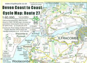
Devon Coast To Coast Cycle Map - Route 27

Devon Coast to Coast Cycle Route, No. 27 in the Sustrans National Cycle Network, presented at 1:60, 000 on a handy size, 50x35cm, double-sided contoured map from Croydecycle, printed on waterproof and tear-resistant synthetic paper. The 160km (100 miles) route from Ilfracombe to Plymouth, via Barnstaple, Bideford, Great Torrington, Okehampton and Tavistock, is presented on four wide strips to enable exploration of surrounding countryside or to follow a different return route. The map shows the route as No. 27 and its alternatives as 27a or 27w (west).Contours are at 30m intervals, with colouring for woodlands (indicating those with public access), sandy or pebble beaches, plus moors and common or other access land. Interesting landscape features are highlighted with grading.
Road network indicates A and B road numbers and has gradient markings. Symbols show numerous facilities: campsites and caravan sites, pubs and cafes, local shops, cycle hire, tourist information, places of interest, etc. National Grid coordinates are marked in the margins.Central Ilfracombe, Braunton, Barnstaple, Bideford, Great Torrington, Okehampton, Tavistock and Plymouth are shown on street plan enlargements. Also includes are contact numbers for local campsites, plus tips on best places to take photographs.To see other titles in this series please click on the series link.
RIP - This product is no longer available on our network. It was last seen on 25.09.2019

This page now acts as a permanent archive for this product. Add more information using the comments box below to ensure it can still be found by future generations.

Use our search facility to see if it is available from an alternative contributor.
  • Availability: Out Of Stock
  • Supplier: Stanfords
  • SKU: 9780956613042
Availability: In Stock
£2.99

Product Description

Devon Coast to Coast Cycle Route, No. 27 in the Sustrans National Cycle Network, presented at 1:60, 000 on a handy size, 50x 35cm, double-sided contoured map from Croydecycle, printed on waterproof & tear-resistant synthetic paper. The 160km (100 miles) route from Ilfracombe to Plymouth, via Barnstaple, Bideford, Great Torrington, Okehampton & Tavistock, is presented on four wide strips to enable exploration of surrounding countryside or to follow a different return route. The map shows the route as No. 27 & its alternatives as 27a or 27w (west). Contours are at 30m intervals, with colouring for woodlands (indicating those with public access), sandy or pebble beaches, plus moors & common or other access l&. Interesting landscape features are highlighted with grading. Road network indicates A & B road numbers & has gradient markings. Symbols show numerous facilities: campsites & caravan sites, pubs & cafes, local shops, cycle hire, tourist information, places of interest, etc. National Grid coordinates are marked in the margins. Central Ilfracombe, Braunton, Barnstaple, Bideford, Great Torrington, Okehampton, Tavistock & Plymouth are shown on street plan enlargements. Also

Includes::
are contact numbers for local campsites, plus tips on best places to take photographs. To see other titles in this series please click on the series link.

Reviews/Comments

Add New

Intelligent Comparison

Oooops!
We couldn't find anything!
Perhaps this product's unique.... Or perhaps we are still looking for comparisons!
Click to bump this page and we'll hurry up.

Price History

Vouchers

No voucher codes found.
Do you know a voucher code for this product or supplier? Add it to Insights for others to use.

Facebook

Jargon Buster

Paper - A thin sheet mainly used for writing. Available in a variety of colours. Made mainly from wood pulp.
Waterproof - Resistant to water, usualy specified by depth in metres
Plymouth - A city on the coast of Devon
Size - is the measurement of how big an object is in space.
Network - A link and communication between things. Often computers or people.
Road - a manmade lane or a path that is used to speed up travel.
Resistant - Something that can repel against something.
Wide - Something with a large width.

Supplier Information

Stanfords
Stanfords was established in 1853 and opened their iconic Covent Garden flagship store in 1901. They have become the top retailer of maps, travel books and accessories in the UK and arguably offer the largest selection of maps and travel books worldwide. Famous names such as Captain Robert Falcon Scott, Ranulph Fiennes and Michael Palin have purchased from Stanfords. They now have a shop in Bristol and both stores together with other venues operate a calendar of events including talks, book signings and exhibitions. As a specialist map retailer, the map selection is comprehensive and includes road maps, street maps and walking maps from worldwide destinations, as well as a selection of world atlases and wall maps. Books include travel guides and travel literature. Stanfords also stock globes, from miniatures made of blue marble to magnificent floor-standing globes. The website features a selection of interesting articles on travel topics.
Page Updated: 2023-11-12 20:15:36

Community Generated Product Tags

Oh No! The productWIKI community hasn't generated any tags for this product yet!
Menu