
 United Kingdom
 France
 Germany
 Netherlands
 Sweden
 USA
USA
 Italy
Italy
 Spain
Spain
More From Contributor


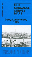
Derry/Londonderry 1905
Derry/Londonderry in 1905 in a fascinating series of reproductions of old Ordnance Survey plans in the Alan Godfrey Editions, ideal for anyone interested in the history of their neighbourhood or family. Coverage stretches from Brooke Park southward to Carlisle Bridge, and from the Cemetery eastward to Glendermott Road. Major features include the city centre, St Columb`s Cathedral, St Columb`s College, Distillery, Custom House, city walls, St Eugene`s RC Cathedral, Christ Church, lunatic asylum, museum, shirt and collar factories, transit sheds on quayside, Queen`s Quay, Prince`s Quay, Abercorn Quay, St Augustine`s church, bacon curing establishment, The Diamond, Butter Market, Nazareth House, tramways, Great Northern Railway with terminus, Guildhall, etc. On the
east side of the River Foyle features include Donegal Railway with part of terminus (southern margin of map), Midland Railway with terminus, Waterside area, St Columb`s RC church, Waterside Distillery, workhouse, Ebrington Barracks, St Columb`s chapel, etc. On the reverse the map has a selection of street directory entries. About the Alan Godfrey Editions of the 25” OS Series:Selected towns in Great Britain and Ireland are covered by maps showing the extent of urban development in the last decades of the 19th and early 20th century. The plans have been taken from the Ordnance Survey mapping and reprinted at about 15 inches to one mile (1:4, 340). On the reverse most maps have historical notes and many also include extracts from contemporary directories. Most maps cover about one
mile (1.6kms) north/south, one and a half miles (2.4kms) across; adjoining sheets can be combined to provide wider coverage.FOR MORE INFORMATION AND A COMPLETE LIST OF ALL AVAILABLE TITLES PLEASE CLICK ON THE SERIES LINK.

Product Description
Reviews/Comments
Add New
Vouchers
No voucher codes found.
Do you know a voucher code for this product or supplier? Add it to Insights for others to use.
Do you know a voucher code for this product or supplier? Add it to Insights for others to use.
 Denmark