More From Contributor
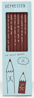
£35.00
Instagram is the 1 source for photography talent & breath-taking locations to spend the night & enjoy the sunrise. Curated by The Sizoo Brothers, Depart unveils the whereabouts of some of the best locations, making this an inspirational photography book & a practical guide for travel enthusiasts. The book contains over 40 stunning destinations from around the world, including practical travelling information, captured by up-&-coming as well as established photographers. ...
Archived Product
£6.99
Step inside this grand department store from the Edwardian era, with six floors to explore. Children will enjoy decorating the store with exquisite flowers & furnishings & arranging items for sale, from a rocking horse & tin soldiers in the children`s department to glamorous evening gowns & shawls in the clothing department. ...
Archived Product
£5.99
The way we shop has undergone many transformations over the years
- & a pioneer of one such change was the department store. Selling
...
Archived Product
£9.99
` Whatever else we remember of our travels, we remember our departures & arrivals. Often they are the most enduring of all our memories of them.` From one of Britain`s best-loved travel writers comes a fascinating collection of incredible highlights from an eventful life. Acutely observant, with an eye for quirky detail & a wit of charming self-deprecation, Eric Newby has delighted readers with his travels, whether to remote locations or his very own back garden. In this captivating collection of 19 tales, Newby invites the reader to join him as he navigates the globe, from the shops & streets of the pram-vantaged Barnes of yesteryear to a mysterious opal-mining town in Australia, & from the faded glamour of the Orient Express to a cycle ride along the Meridian Line, navigating rivers & ill-placed homes. As a forefather of the modern comic travel book, Newby`s insatiable curiosity & infectious enthusiasm have garnered him an incredible following over many decades. ` Departures & Arrivals` is a superb showcase of Eric Newby`s distinctive storytelling & boundless energy that will delight both existing fans & new admirers. ...
Archived Product
£7.99
No. 1 New York Times bestselling author Patricia Cornwell delivers the twenty-third engrossing thriller in her high-stakes series starring medical examiner Dr. Kay Scarpetta. You are being watched The death of a Hollywood mogul`s daughter has the police convinced it`s an accident. But Dr. Kay Scarpetta knows better. It`s almost as if someone is leaving evidence only she would spot. They are always three steps ahead Scarpetta is sidetracked when she receives a video clip revealing disturbing secrets about her niece, Lucy. But before she can react, the FBI raid Lucy`s estate. Time is running out Scarpetta suspects one person is behind it all: the murder, the videos, the FBI. She needs to stop them before it`s too late
- & everyone she loves is destroyed.
...
Archived Product
£3.50
Deptford North in 1868 in a fascinating series of reproductions of old Ordnance Survey plans in the Alan Godfrey Editions, ideal for anyone interested in the history of their neighbourhood or family. Three versions have been published for this area, stretching from Canterbury Rd & Ormside Street eastward to Deptford Green, & from Rotherhithe Road & Deptford Wharf southward to St Paul`s church. Features include the Royal Dockyard & Royal Victoria Victualling Yard
- shown in detail on the 1868 map, the northern part of Deptford High St, Evelyn Street, the Grand Surrey Canal, Coldblow Farm, the Thames Junction Branch railway, St Helena Gardens, numerous railway lines, The Den Millwall FC, Southwark Park station Foreign Cattle Market, a small section of West Ferry Road on the north bank of river, various tramways. Churches include St Paul`s Deptford. Roads on the 1868 map include Evelyn St, Plough Road, Edward St, Old King St, Rotherhithe New Rd, White Post Lane, Chilton St, & part of Deptford High St. About the Alan Godfrey Editions of the 25” OS Series: Selected towns in Great Britain & Ireland are covered by maps showing the extent of urban development in the last decades of the 19th & early 20th century. The plans have been taken from the Ordnance Survey mapping & reprinted at about 15 inches to one mile (1:4, 340). On the reverse most maps have historical notes & many also include extracts from contemporary directories. Most maps cover about one mile (1.6kms) north/south, one & a half miles (2.4kms) across; adjoining sheets can be combined to provide wider coverage.FOR MORE INFORMATION & A COMPLETE LIST OF ALL AVAILABLE TITLES PLEASE CLICK ON THE SERIES LINK.
...
Archived Product
£3.50
Deptford North in 1894 in a fascinating series of reproductions of old Ordnance Survey plans in the Alan Godfrey Editions, ideal for anyone interested in the history of their neighbourhood or family. Three versions have been published for this area, stretching from Canterbury Rd & Ormside Street eastward to Deptford Green, & from Rotherhithe Road & Deptford Wharf southward to St Paul`s church. Features include the Royal Dockyard & Royal Victoria Victualling Yard, the northern part of Deptford High St, Evelyn Street, the Grand Surrey Canal, Coldblow Farm, the Thames Junction Branch railway, St Helena Gardens, numerous railway lines, The Den Millwall FC, Southwark Park station Foreign Cattle Market, a small section of West Ferry Road on the north bank of river, various tramways. Churches include St Paul`s Deptford. About the Alan Godfrey Editions of the 25” OS Series: Selected towns in Great Britain & Ireland are covered by maps showing the extent of urban development in the last decades of the 19th & early 20th century. The plans have been taken from the Ordnance Survey mapping & reprinted at about 15 inches to one mile (1:4, 340). On the reverse most maps have historical notes & many also include extracts from contemporary directories. Most maps cover about one mile (1.6kms) north/south, one & a half miles (2.4kms) across; adjoining sheets can be combined to provide wider coverage.FOR MORE INFORMATION & A COMPLETE LIST OF ALL AVAILABLE TITLES PLEASE CLICK ON THE SERIES LINK. ...
Archived Product
£3.50
Deptford North in 1914 in a fascinating series of reproductions of old Ordnance Survey plans in the Alan Godfrey Editions, ideal for anyone interested in the history of their neighbourhood or family. Three versions have been published for this area, stretching from Canterbury Rd & Ormside Street eastward to Deptford Green, & from Rotherhithe Road & Deptford Wharf southward to St Paul`s church. Features include the Royal Dockyard & Royal Victoria Victualling Yard, the northern part of Deptford High St, Evelyn Street, the Grand Surrey Canal, Coldblow Farm, the Thames Junction Branch railway, St Helena Gardens, numerous railway lines, The Den Millwall FC, Southwark Park station Foreign Cattle Market, a small section of West Ferry Road on the north bank of river, various tramways. Churches include St Paul`s Deptford. About the Alan Godfrey Editions of the 25” OS Series: Selected towns in Great Britain & Ireland are covered by maps showing the extent of urban development in the last decades of the 19th & early 20th century. The plans have been taken from the Ordnance Survey mapping & reprinted at about 15 inches to one mile (1:4, 340). On the reverse most maps have historical notes & many also include extracts from contemporary directories. Most maps cover about one mile (1.6kms) north/south, one & a half miles (2.4kms) across; adjoining sheets can be combined to provide wider coverage.FOR MORE INFORMATION & A COMPLETE LIST OF ALL AVAILABLE TITLES PLEASE CLICK ON THE SERIES LINK. ...
Archived Product
£7.99
October 1914: the destroyer Svea emerged from the Stockholm archipelago bearing south-south-east. On board was Lars Tobiasson-Svartman, a naval engineer charged with making depth soundings for the Swedish navy. He is obsessed with measurement & precision, instincts reflected in his comfortable but cold relationship with his wife. Close to where soundings are taken, Lars rows out to a barren reef, presumed uninhabited, & discovers a young woman there. Despite her almost feral appearance, Sara stirs something in him. The mission is a success & the Svea returns to Gothenburg. Lars, however, remains haunted by this chance encounter, & feels compelled to return... ...
Archived Product
£6.39
A detailed topographic map of Derby from the Ordnance Survey Explorer series, covering Uttoxeter, Ashbourne & Cheadle.5 Edition A1 with minor changes; Publication date February 2008 About this series: These highly detailed maps show all the administrative boundaries, settlements as small as isolated farms, the road network down to unfenced roads & country tracks, & field boundaries (hedges & drystone walls) which make navigation across the countryside much easier. Steep gradients on roads are indicated. Various landmarks, e.g. powerlines, archaeological sites, windmills, churches & lighthouses are shown & additional graphics indicate natural terrain features such as cliffs, scree, mud & vegetation variations. The contour interval is 5 metres in the lower parts of the country & 10 metres in the uplands, & spot heights are marked. Each map covers an area of 30 x 20km (i.e. approx. 19 x 12 miles), with some double-sided maps covering more, as indicated in the individual descriptions. The maps are fully GPS compatible, with the National Grid shown at 1km intervals & latitude & longitude indicated by margin ticks at 1'. The Explorer series has replaced the earlier, green-cover Pathfinder maps. The Explorer series is now complete & covers all of Engl&, Wales & Scotl&. Some sheets for popular areas like the National Parks are still branded as Outdoor Leisure (OL) maps, but are now included in this series as the cartography is the same as that in the Explorer Maps. The Explorer maps offer a substantial improvement on the Pathfinder series, with greater use of colour, larger area per map, & stronger emphasis on information for ramblers & tourists. This series is ideal for walking & other outdoor pursuits & each map shows a large amount of information for ramblers & tourists. Public rights of way are shown (except in Scotland), together with other routes with public access: National Trails & Recreational Paths, permitted paths & bridleways, & selected cycle routes. Open access land created under the Countryside & Rights of Way Act 2000 is marked. Tourist information

Includes::
caravan & camp sites, Park & Ride locations, recreation/leisure/sport centres, museums, historic buildings, English Heritage & National Trust sites, rural pubs, etc. The map legend is in English only, except for the tourist information content which is also in French & German.

...
Archived Product

Depressed Pencils

The pencil is a wonderful thing, needed by everyone at some point (and needed always by some of us), but these ones have forgotten: ”I`m easily broken, ” ”In time I`ll be pointless, ” ”You`re going to write me off” and more. Find a place in your heart for the classic writing tool, for which ”worn down” just means well-loved!6 HB pencils in a themed box.Pack measures 19x6x1.5cm
RIP - This product is no longer available on our network. It was last seen on 25.09.2019

This page now acts as a permanent archive for this product. Add more information using the comments box below to ensure it can still be found by future generations.

Use our search facility to see if it is available from an alternative contributor.
  • External links may include paid for promotion
  • Availability: Out Of Stock
  • Supplier: Stanfords
  • SKU: 5060406340099
Availability: In Stock
£5.99

Product Description

The pencil is a wonderful thing, needed by everyone at some point (and needed always by some of us), but these ones have forgotten: ”I`m easily broken, ” ” In time I`ll be pointless, ” ” You`re going to write me off” & more. Find a place in your heart for the classic writing tool, for which ”worn down” just means well-loved!6 HB pencils in a themed box. Pack measures 19x 6x 1.5cm

Reviews/Comments

Add New

Intelligent Comparison

Oooops!
We couldn't find anything!
Perhaps this product's unique.... Or perhaps we are still looking for comparisons!
Click to bump this page and we'll hurry up.

Price History

Vouchers

No voucher codes found.
Do you know a voucher code for this product or supplier? Add it to Insights for others to use.

Facebook

Jargon Buster

Heart - An organ that pumps blood around the body. Usually related to love.
Classic - Something that is still like it was originally a high quality standard.
Wonderful - Another word for describing something that is extremely good, marvellous.

Supplier Information

Stanfords
Stanfords was established in 1853 and opened their iconic Covent Garden flagship store in 1901. They have become the top retailer of maps, travel books and accessories in the UK and arguably offer the largest selection of maps and travel books worldwide. Famous names such as Captain Robert Falcon Scott, Ranulph Fiennes and Michael Palin have purchased from Stanfords. They now have a shop in Bristol and both stores together with other venues operate a calendar of events including talks, book signings and exhibitions. As a specialist map retailer, the map selection is comprehensive and includes road maps, street maps and walking maps from worldwide destinations, as well as a selection of world atlases and wall maps. Books include travel guides and travel literature. Stanfords also stock globes, from miniatures made of blue marble to magnificent floor-standing globes. The website features a selection of interesting articles on travel topics.
Page Updated: 2023-11-12 20:15:36

Community Generated Product Tags

Oh No! The productWIKI community hasn't generated any tags for this product yet!
Menu