More From Contributor
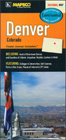
£2.95
Denton with Haughton in 1904 in a fascinating series of reproductions of old Ordnance Survey plans in the Alan Godfrey Editions, ideal for anyone interested in the history of their neighbourhood or family. Selected towns in Great Britain & Ireland are covered by maps showing the extent of urban development in the last decades of the 19th & early 20th century. In this title: the map covers the area around & to the north of Haughton Green, with the Stockport Road area of south Denton to the north. Coverage stretches from Hyde Hall eastward to Gibraltar Mill on the River Tame. Other features include Denton cemetery, Great Wood Pit, Denton Colliery, Three Lane Ends, Vinery Hat Works, Town Lane, Moorfield Mills, St Mary's church, Whittles Farm etc. On the reverse is a selection of street directory entries, including Gibraltar Lane, Haughton Green Road, Stockport Road & Two Trees Lane. About the Alan Godfrey Editions of the 25 ...
Archived Product
£3.50
Denton with Haughton in 1904 in a fascinating series of reproductions of old Ordnance Survey plans in the Alan Godfrey Editions, ideal for anyone interested in the history of their neighbourhood or family. The map covers the area around & to the north of Haughton Green, with the Stockport Road area of south Denton to the north. Coverage stretches from Hyde Hall eastward to Gibraltar Mill on the River Tame. Other features include Denton cemetery, Great Wood Pit, Denton Colliery, Three Lane Ends, Vinery Hat Works, Town Lane, Moorfield Mills, St Mary`s church, Whittles Farm, etc. On the reverse is a selection of street directory entries, including Gibraltar Lane, Haughton Green Road, Stockport Road & Two Trees Lane. About the Alan Godfrey Editions of the 25” OS Series: Selected towns in Great Britain & Ireland are covered by maps showing the extent of urban development in the last decades of the 19th & early 20th century. The plans have been taken from the Ordnance Survey mapping & reprinted at about 15 inches to one mile (1:4, 340). On the reverse most maps have historical notes & many also include extracts from contemporary directories. Most maps cover about one mile (1.6kms) north/south, one & a half miles (2.4kms) across; adjoining sheets can be combined to provide wider coverage.FOR MORE INFORMATION & A COMPLETE LIST OF ALL AVAILABLE TITLES PLEASE CLICK ON THE SERIES LINK. ...
Archived Product
£9.99
Did you know that.. . a soldier`s biggest social blunder is called jack brew
- making yourself a cuppa without making one for anyone
...
Archived Product
£11.99
About this series A series of practical guides covering many major US cities. Each title offers a range of entries for accommodation & restaurants to suit most budgets. Parks, gardens, museums, galleries, children's attractions, shopping, entertainment & nightlife all have individual chapters. Contact addresses for everything from canoeing & hiking to golf & horse riding. ...
Archived Product
£7.99
Denver in Colorado on an indexed street plan from Rand Mc Nally in their extensive range of maps covering cities in the United States, with enlargements showing in greater detail downtown Denver & access to the city’s international airport. Communities covered by this map include Arvada, Aurora, Centennial, Commerce City, Englewood, Glendale, Greenwood Village, Lakewood, Littleton, Thornton, Westminster & Wheat Ridge.NEW STREET PLAN CARTOGRAPHY FROM RAND Mc NALLY: Rand Mc Nally are currently changing the cartography of their street plans to a more “ European” style. In many titles streets are now shown by parallel lines, providing a much clearer, easier to read presentation. Better use of colouring indicates different types of land use and/or institutions (parks, shopping centres, academic institutions, etc) &, in most titles, different administrative units. More streets are annotated with block numbers. Some new editions still retain the traditional American presentation of streets by a single line, but with more prominent marking for various institutions, facilities & places of interest. Our cartography sample indicates which style is used in this title.COVERAGE: Rand Mc Nally street plans cover cities with their outer suburbs, prominently highlighting principal traffic arteries & connecting main streets. Railway & subway stations are marked. ...
Archived Product
£7.99
Denver & vicinity in a series of Rand Mc Nally’s regional road maps covering the environs of main US cities. Insets show downtown Denver & access to the city’s airport. Coverage extends north beyond Fort Collins, & south beyond Colorado Springs to Pueblo. In the west the map extends beyond the Peak to Peak Highway to include numerous peaks of the Rocky Mountains. Other communities covered by this map include Arvada, Aurora, Boulder, Cañon City, Castle Rock, Lakewood, Longmont, Lovel&, & parker. Maps in this series present the road network on a clear background with no relief shading to show the area’s topography, but with national or state parks, forests & other protected areas indicated by colouring. Roads are numbered and/or named, showing toll highways, exit numbers of interchanges, services & rest areas. Local airports are marked, but railways & other urban transport lines are not included unless specifically indicated in the individual description. Each town is presented in a different colour, providing those unfamiliar with the region a very clear picture of the area. Various places of interest & facilities are highlighted, including cultural & historical sites, educational institutions, sport & recreational facilities, etc. Each title is indexed. Several maps also include enlargements of the downtown area, plans of international airports, a mileage & driving times diagram for a much wider region than covered by the main map, etc
- for more information please see the individual descriptions. To see all the titles in this series please click on the series link.
...
Archived Product
£6.50
Denver in Colorado on an indexed street plan from Rand Mc Nally in their extensive range of maps covering cities in the United States. Communities covered by this title include Arvada, Aurora, Centennial, Commerce City, Englewood, Glendale, Greenwood Village, Lakewood, Littleton, Thornton, Westminster & Wheat Ridge. Rand Mc Nally street plans provide coverage of cities with their outer suburbs, clearly indicating main traffic arteries: highways (distinguishing between free & toll access), plus primary & secondary routes. Road numbers and/or names are clearly displayed & exit numbers are indicated. Locations of service & rest areas are marked & one way streets are shown. Longer streets are annotated with block numbers for easier identification of addresses. The maps show railway, bus &, where appropriate, metro stations. A range of symbols indicate various places of interest including cultural & academic institutions, various municipal facilities, golf courses, etc. The plans have extensive street indexes, supplemented by lists of points of interest, parks & recreational areas, shopping malls, stations, schools, etc. Descriptions of individual titles indicate if an enlargement of the downtown area or any other additional features are also provided. ...
Archived Product
£35.00
Instagram is the 1 source for photography talent & breath-taking locations to spend the night & enjoy the sunrise. Curated by The Sizoo Brothers, Depart unveils the whereabouts of some of the best locations, making this an inspirational photography book & a practical guide for travel enthusiasts. The book contains over 40 stunning destinations from around the world, including practical travelling information, captured by up-&-coming as well as established photographers. ...
Archived Product
£6.99
Step inside this grand department store from the Edwardian era, with six floors to explore. Children will enjoy decorating the store with exquisite flowers & furnishings & arranging items for sale, from a rocking horse & tin soldiers in the children`s department to glamorous evening gowns & shawls in the clothing department. ...
Archived Product

Denver County, CO

Denver County in Colorado on a laminated, waterproof and tear-resistant road map from Mapsco, with an enlargement showing the city’s downtown area in greater detail. On one side the city and the surrounding area are shown at 1:217, 000 approx, with coverage extending north to Fort Collins, east to Bennett, south to Castle Rock and west to Black Hawk. Coverage includes the counties of Adams, Arapahoe, Boulder, Larimer and Weld. The map indicates controlled access highways, toll roads, main through routes, etc. Road numbers are clearly marked. Also shown are municipal and zip code boundaries and symbols indicate locations of various facilities and places of interest. The index lists both localities and streets.On the reverse a 43x22cm panel shows downtown Denver in greater
detail, highlighting various facilities and places of interest.
RIP - This product is no longer available on our network. It was last seen on 25.09.2019

This page now acts as a permanent archive for this product. Add more information using the comments box below to ensure it can still be found by future generations.

Use our search facility to see if it is available from an alternative contributor.
  • External links may include paid for promotion
  • Availability: Out Of Stock
  • Supplier: Stanfords
  • SKU: 9780762583171
Availability: In Stock
£9.99

Product Description

Denver County in Colorado on a laminated, waterproof & tear-resistant road map from Mapsco, with an enlargement showing the city’s downtown area in greater detail. On one side the city & the surrounding area are shown at 1:217, 000 approx, with coverage extending north to Fort Collins, east to Bennett, south to Castle Rock & west to Black Hawk. Coverage

Includes::
the counties of Adams, Arapahoe, Boulder, Larimer & Weld. The map indicates controlled access highways, toll roads, main through routes, etc. Road numbers are clearly marked. Also shown are municipal & zip code boundaries & symbols indicate locations of various facilities & places of interest. The index lists both localities & streets. On the reverse a 43x 22cm panel shows downtown Denver in greater detail, highlighting various facilities & places of interest.

Reviews/Comments

Add New

Intelligent Comparison

Oooops!
We couldn't find anything!
Perhaps this product's unique.... Or perhaps we are still looking for comparisons!
Click to bump this page and we'll hurry up.

Price History

Vouchers

No voucher codes found.
Do you know a voucher code for this product or supplier? Add it to Insights for others to use.

Facebook

Jargon Buster

ZIP - A device (Usualy Metal) used for temporarily attaching two pieces of fabric together
Black - A colour which does not emit any colour of the spectrum. Black absorbs all frequencies of the spectrum.
Waterproof - Resistant to water, usualy specified by depth in metres
Road - a manmade lane or a path that is used to speed up travel.
Zip - A Fastening which can open and close to get inside.
Resistant - Something that can repel against something.
Laminated - A thin layer of plastic that gives a coating and shine to a material.

Supplier Information

Stanfords
Stanfords was established in 1853 and opened their iconic Covent Garden flagship store in 1901. They have become the top retailer of maps, travel books and accessories in the UK and arguably offer the largest selection of maps and travel books worldwide. Famous names such as Captain Robert Falcon Scott, Ranulph Fiennes and Michael Palin have purchased from Stanfords. They now have a shop in Bristol and both stores together with other venues operate a calendar of events including talks, book signings and exhibitions. As a specialist map retailer, the map selection is comprehensive and includes road maps, street maps and walking maps from worldwide destinations, as well as a selection of world atlases and wall maps. Books include travel guides and travel literature. Stanfords also stock globes, from miniatures made of blue marble to magnificent floor-standing globes. The website features a selection of interesting articles on travel topics.
Page Updated: 2023-11-12 20:15:36

Community Generated Product Tags

Oh No! The productWIKI community hasn't generated any tags for this product yet!
Menu