More From Contributor

£3.50
Dartford in 1905 in a fascinating series of reproductions of old Ordnance Survey plans in the Alan Godfrey Editions, ideal for anyone interested in the history of their neighbourhood or family. The map covers the centre of Dartford, extending southward to Oakfield Lane & the northern tip of Wilmington parish. Features include West Hill, Spital Street, High Street in detail with individual buildings shown; Acacia Hall, Livingstone Cottage Hospital, Trinity church, Workhouse, River Darent, Masonic Hall, pumping station, The Dene, Shepherd`s Lane area, Brickhill Woods, Heathclose House (at western edge of map), gravel pits, Sessions House, cattle market etc. On the reverse is a list of private residents from a 1905 directory. About the Alan Godfrey Editions of the 25” OS Series Selected towns in Great Britain & Ireland are covered by maps showing the extent of urban development in the last decades of the 19th & early 20th century. The plans have been taken from the Ordnance Survey mapping & reprinted at about 15 inches to one mile (1:4, 340). On the reverse most maps have historical notes & many also include extracts from contemporary directories. Most maps cover about one mile (1.6kms) north/south, one & a half miles (2.4kms) across; adjoining sheets can be combined to provide wider coverage.FOR MORE INFORMATION & A COMPLETE LIST OF ALL AVAILABLE TITLES PLEASE CLICK ON THE SERIES LINK. ...
Archived Product
£3.50
Dartford & Gravesend in 1893 in a series of reproductions of Ordnance Survey’s famous ” Inch to the Mile” maps published in the Alan Godfrey Editions to provide a historical record of England & Wales in the second half of 19th & early 20th century. The map covers an area from Bromley eastward to Gravesend & from Erith southward to Halsted, with north of the Thames a small portion of Essex around Tilbury & Grays. Coverage also
Includes:: in ESSEX Chadwell St Mary`s, Grays, Little Thurrock, Purfleet, Tilbury, West Thurrock, & West Tilbury; plus in KENT Ash, Bexley, Bromley, Chalk, Charlton, Chelsfield, Chislehurst, Cobham, Crayford, Eltham, Erith, Eynsford, Farnborough, Farningham, Fawkham, Foots Cray, Greenhithe, Halsted, Hartley, Hayes, Horton Kirkby, Keston, Kidbrooke, Kingsdown, Longfield, Luddesdown, Lullingstone, Meopham, Mottingham, North Cray, Northfleet, Nursted, Orpington, Plumstead, Ridley, Shinglewell, Shoreham, St Mary Cray, St Paul`s Cray, Stansted, Stone, Sutton at Hone, Swanley, Swanscombe, Welling, Wilmington, & Woolwich. On the reverse is a more detailed map of the centre of Betsham, including Southfleet station.* About the Alan Godfrey Editions of the OS Inch to the Mile Maps:* The maps provide an invaluable overview of a wider area, typically 18 x 12 miles (29 x 19 kms approx.), & offer historical mapping for small towns & villages not covered by the more detailed series for which the Godfrey Editions are better known. On the reverse all the maps have historical notes & most titles also include a more detailed, large scale map of a small town or a village in the area. To see other titles in this series please click on the series link.
...
Archived Product
£4.50
Street by Street Dartford, Gravesend Midi has been fully updated with a stylish new cover design, in a handy glovebox size. Quick to navigate & easy-to-use, the maps clearly show AA recommended restaurants, pubs, hotels, one-way streets & car parks. Featuring a clever use of colour to ensure it can be read under street lighting, & National Grid referencing, Street by Street Dartford, Gravesend Midi is all you need to keep you on the move. ...
Archived Product
£6.39
A detailed topographic map from the Ordnance Survey Explorer series, covering Dartmoor (showing part of the Dartmoor National Park). Edition B3; Publication date August 2010 About this series: These highly detailed maps show all the administrative boundaries, settlements as small as isolated farms, the road network down to unfenced roads & country tracks, & field boundaries (hedges & drystone walls) which make navigation across the countryside much easier. Steep gradients on roads are indicated. Various landmarks, e.g. powerlines, archaeological sites, windmills, churches & lighthouses are shown & additional graphics indicate natural terrain features such as cliffs, scree, mud & vegetation variations. The contour interval is 5 metres in the lower parts of the country & 10 metres in the uplands, & spot heights are marked. Each map covers an area of 30 x 20km (i.e. approx. 19 x 12 miles), with some double-sided maps covering more, as indicated in the individual descriptions. The maps are fully GPS compatible, with the National Grid shown at 1km intervals & latitude & longitude indicated by margin ticks at 1'. The Explorer series has replaced the earlier, green-cover Pathfinder maps. The Explorer series is now complete & covers all of Engl&, Wales & Scotl&. Some sheets for popular areas like the National Parks are still branded as Outdoor Leisure (OL) maps, but are now included in this series as the cartography is the same as that in the Explorer Maps. The Explorer maps offer a substantial improvement on the Pathfinder series, with greater use of colour, larger area per map, & stronger emphasis on information for ramblers & tourists. This series is ideal for walking & other outdoor pursuits & each map shows a large amount of information for ramblers & tourists. Public rights of way are shown (except in Scotland), together with other routes with public access: National Trails & Recreational Paths, permitted paths & bridleways, & selected cycle routes. Open access land created under the Countryside & Rights of Way Act 2000 is marked. Tourist information

Includes::
caravan & camp sites, Park & Ride locations, recreation/leisure/sport centres, museums, historic buildings, English Heritage & National Trust sites, rural pubs, etc. The map legend is in English only, except for the tourist information content which is also in French & German.

...
Archived Product
£50.00
New Naturalist Dartmoor explores the complex & fascinating history of one of southern England's greatest National Parks, an area of enormous interest to naturalists & tourists alike. Dartmoor is said to be the loneliest wilderness in Engl&. This has been said more often of Dartmoor than any other part of our country. Traditionally in the world of fiction as well as that of fact, Dartmoor has been renowned as a vast & empty moorland area, the property of nature rather than of man. It has always been the public's idea of a lonely place. Not many generations ago it was regarded with a certain amount of awe & nowadays it is one of our most important centres of recreation, an island in upland England of abundant interest to the naturalist. In 1951 it became a National Park, one of the first of several places that have been so designated in Great Britain, helping to conserve & promote both its beauty & cultural heritage. Spanning miles of open moorl&, whilst also hiding small secluded river valleys, rare plants & endangered birds, Dartmoor is a place of variety, & has evolved in the public's mind from a forbidding place to that of romance & mystery. In the latest addition to the long-running New Naturalist series, Ian Mercer sets out to explore every aspect of this important area of southern Devon. Focusing not only on its extensive history & physical landscape, but also its cultural place within Great Britain, this is both a comprehensive & engaging look at the wild & rugged landscape that has inspired so many poets, painters & musicians over countless centuries. ...
Archived Product
£7.99
Short Walks Dartmoor covering parts of Okehampton, Chagford & Lustleigh. This selection offers interest & regional variety in Dartmoor, providing the best short walks in the area. Covering walks through the whole of Dartmoor, both popular & little know scenic routes including High Willhays, Haytor Teign gorge & Castle Drogo.
- See walk locations by Looking Inside Inside: -20 circular walks up to 5 miles
- Clear, large scale Ordnance Survey route maps
- GPS reference for all Dartmoor waypoints
- Where to park, good pubs & places of interest en route
- All routes have been fully researched & written by expert outdoor writers
- Beautiful photography of scenes from the walks Ideal for families, or for those who prefer shorter distances, Short Walks guides contain 20 walks graded by distance, duration & difficulty. Each route

Includes::
points of interest as well as fun observation questions for children.


...
Archived Product
£7.99
Dartmoor in the Short Walks guide series, produced in association with Ordnance Survey & published by Crimson; comprising a range of walking guides to popular British destinations. Each title

Includes::
20 varied walks that are suitable for walkers of all ages & abilities & is accompanied by detailed Explorer 1:25, 000 Ordnance Survey mapping with colour-coded marked routes. The guides are structured in three main sections with different levels of difficulty- short & easy walks, those of modest length that may include uphill walking & more challenging routes that may be longer & over more rugged terrain- covering a total of 20 walks. Each walk has a mini summary & an information box with details of starting points, distance, approximate time, parking & any individual route features. There is also information on refreshments, local transport & public toilets en route. Appendices provide further useful information on walking safety, GPS, the Countryside Code, local organisations & Ordnance Survey maps.

...
Archived Product
£3.50
Dartmoor in 1908 in a series of reproductions of Ordnance Survey’s famous ” Inch to the Mile” maps published in the Alan Godfrey Editions to provide a historical record of England & Wales in the second half of 19th & early 20th century. Voverage stretches from Marytavy & Whitchurch eastwards to Ashburton, & from Lydford southwards to Buckfast Abbey & Sheepstor. Other locations include Buckland in the Moor, Buckland Monarchorun, Holne, Manaton, North Bovey, Petertavy, Princetown, Sampford Spiney, Walkhampton & Widecombe in the Moor. On the reverse is an extract from Devon Sheet 106.08 of the area immediately around Dartmoor prison in 1904, with a directory of Princetown. About the Alan Godfrey Editions of the OS Inch to the Mile Maps: the maps provide an invaluable overview of a wider area, typically 18 x 12 miles (29 x 19 kms approx.), & offer historical mapping for small towns & villages not covered by the more detailed series for which the Godfrey Editions are better known. On the reverse all the maps have historical notes & most titles also include a more detailed, large scale map of a small town or a village in the area. To see other titles in this series please click on the series link. ...
Archived Product
£7.95
Dartmoor at 1:25, 000 in a series of handy A5 size Adventure Atlases from Geographers` A-Z Map Company with cartography from the Ordnance Survey’s Explorer series. Coverage

Includes::
High Willhays, Rough Tor, Hattor Rocks, Sheeps Tor, Sharp Tor, Oakhampton, Moretonhampsead, Bovey Tracey, Ashburton, Buckfastleigh, Ivybridge, Tavistock, etc. To see other titles in this series please click on the series link.A-Z Adventure Atlases have cartography of the Ordnance Survey’s Explorer maps & provide plenty of recreational & tourist information, indicating traditional public rights of way paths, including bridleways & byways restricted or open to motorized traffic. Also shown are other routes with public access, including permissive footpaths & bridleways. Special marking indicates National Trails, Long-distance Routes & Recreational Routes, & for cyclists the maps show traffic-free routes & the National Cycle Network. A wide range of symbols highlights locations of special tourist interest: camping & caravanning sites, youth hostels, information offices & visitors’ centres, parking & picnicking places, historic buildings (indicating where appropriate National Trust, English Heritage, or Cadw), sites for various recreational pursuits, country pubs, public toilets, etc. The mapping provides detailed presentation of the topography with contours at 5 or 10m intervals, numerous spot heights & colouring and/or graphics for different types of terrain or vegetation. Additional colouring shows access l&, including areas managed by the National Trust, Forestry Commission & Woodland Trust. All the standard information expected of high quality survey mapping at this scale is included: finely graded road network, railway lines with stations, cuttings or embankments, individual isolated buildings, etc. For GPS each page as a 1-km British National Grid. Each atlas has an index which

Includes::
geographical features, nature reserves, youth hostels, car parks, etc, & provides additional notes on safety & security when walking, plus QR codes for obtaining by mobile phone information about local weather, danger areas, mountain rescue, map reading, OS National Grid coordinates, etc.


...
Archived Product
£71.50
The product contains 1:25, 000 (OS Explorer) digital map data & aerial photography of the region, which can be zoomed & scrolled. It is seamless, continuous map data, loaded in the background, which can be worked with in feet, meters, miles or kilometers. OS Grid or Latitude/ Longitude can be used for co-ordinates. Waypoints, paths & personal routes can all be added & printed, with hill profiles to view height changes on paths. Supports Garmin & Magellan GPS for exchange of routes, waypoints etc.

Includes::
complete GB Overview Map & Road Atlas at 1:250, 000 scale, with route planning tools & a Gazetteer of locations. Minimum system requirement: Windows 2000/XP, 256 Mb RAM memory. Recommended: XP, 1.5 G Hz processor, 1GB RAM memory. Virtual Landscape requires Direct X 9 compatible video card.

...
Archived Product

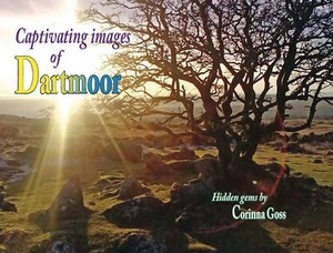
Dartmoor - Captivating Images

Corrina introduces you to this stunning new book...I have been walking on Dartmoor for the past twenty years so I`m pretty sure that according to some very old, possibly written in stone law, the moor belongs to me now. Cool! It`s the most beautiful, magical place, overflowing with history that dates back thousands of years, and it`s everywhere. It`s got spooky stuff too, like Witches, the Devil, Hell hounds, Pixies and Phantom Pigs - what more could you want? I often drag my friends up onto the moor in the middle of the night on ghost walks - they love it. They do get a little nervous though when they hear me say ”I don`t think this is the right path.” Fortunately no one has been tempted away by the Devil, turned to stone by the Witch or been chased away by a phantom piggy -
yet! This little books, is my way of saying thank you to the moor and hopefully showing others some of its beauty. I am not a professional photographer and make no apologies for the rawness of my photos. I go on Dartmoor to walk and enjoy - I am not one for sitting still for hours with camera and tripod trying to capture the perfect light for the perfect picture. Life is too short!The prehistoric remains on Dartmoor are mostly from the Neolithic and early Bronze age period and there are hundreds of them! We`ve got stone rows, round pounds, stone coffins and much more. You just have to know where to look. Some of them are very easy to find as they are literally just by the roadside, others take a bit of trekking and a lot of luck.Very rewarding work though. My favourite place for
antiquities is up around Drizzlecombe which is found on the South moor. Its got impressive stone rows, a good example of a submerged Kistvaen, a giant cairn and some hut circle remains in a round pound. Lots to investigate and its not too far from Ditsworthy Warreners cottage, another great place to visit. Unlike Stonehenge you can get up close and personal with all the antiquities on Dartmoor (unless they are on private land of course) so you can hug, kiss or feel the vibrations to your hearts content!
RIP - This product is no longer available on our network. It was last seen on 25.09.2019

This page now acts as a permanent archive for this product. Add more information using the comments box below to ensure it can still be found by future generations.

Use our search facility to see if it is available from an alternative contributor.
  • Availability: Out Of Stock
  • Supplier: Stanfords
  • SKU: 9781857944242
Availability: In Stock
£9.99

Product Description

Corrina introduces you to this stunning new book...I have been walking on Dartmoor for the past twenty years so I`m pretty sure that according to some very old, possibly written in stone law, the moor belongs to me now. Cool! It`s the most beautiful, magical place, overflowing with history that dates back thousands of years, & it`s everywhere. It`s got spooky stuff too, like Witches, the Devil, Hell hounds, Pixies & Phantom Pigs
- what more could you want? I often drag my friends up onto the moor in the middle of the night on ghost walks
- they love it. They do get a little nervous though when they hear me say ”I don`t think this is the right path.” Fortunately no one has been tempted away by the Devil, turned to stone by the Witch or been chased away by a phantom piggy
- yet! This little books, is my way of saying thank you to the moor & hopefully showing others some of its beauty. I am not a professional photographer & make no apologies for the rawness of my photos. I go on Dartmoor to walk & enjoy
- I am not one for sitting still for hours with camera & tripod trying to capture the perfect light for the perfect picture. Life is too short! The prehistoric remains on Dartmoor are mostly from the Neolithic & early Bronze age period & there are hundreds of them! We`ve got stone rows, round pounds, stone coffins & much more. You just have to know where to look. Some of them are very easy to find as they are literally just by the roadside, others take a bit of trekking & a lot of luck. Very rewarding work though. My favourite place for antiquities is up around Drizzlecombe which is found on the South moor. Its got impressive stone rows, a good example of a submerged Kistvaen, a giant cairn & some hut circle remains in a round pound. Lots to investigate & its not too far from Ditsworthy Warreners cottage, another great place to visit. Unlike Stonehenge you can get up close & personal with all the antiquities on Dartmoor (unless they are on private land of course) so you can hug, kiss or feel the vibrations to your hearts content!

Reviews/Comments

Add New

Intelligent Comparison

Oooops!
We couldn't find anything!
Perhaps this product's unique.... Or perhaps we are still looking for comparisons!
Click to bump this page and we'll hurry up.

Price History

Vouchers

No voucher codes found.
Do you know a voucher code for this product or supplier? Add it to Insights for others to use.

Facebook

Jargon Buster

Camera - An electronic device used for taking photographs
Tripod - A three legged device for supporting an object - commonly a camera.
Friends - A close associate or a popular US based sitcom about a group of friends
History - Anything that happens in the past. An acedemic subject.
Stone - Or Rock is a naturally occuring mineral categorised into three types, Igneous, Sedimentary and Metamorphic
professional - A term used to describe products or people which may be focused on specialist educational training
Love - Someone who shows deep affection for someone else.
Rewarding - Achieving and doing something good.
Professional - A person that is trained within a profession.
Personal - Something that belongs more to an individual due to it affecting them more by relating to them.
Cottage - A house typically found in the country, commonly small in size.

Supplier Information

Stanfords
Stanfords was established in 1853 and opened their iconic Covent Garden flagship store in 1901. They have become the top retailer of maps, travel books and accessories in the UK and arguably offer the largest selection of maps and travel books worldwide. Famous names such as Captain Robert Falcon Scott, Ranulph Fiennes and Michael Palin have purchased from Stanfords. They now have a shop in Bristol and both stores together with other venues operate a calendar of events including talks, book signings and exhibitions. As a specialist map retailer, the map selection is comprehensive and includes road maps, street maps and walking maps from worldwide destinations, as well as a selection of world atlases and wall maps. Books include travel guides and travel literature. Stanfords also stock globes, from miniatures made of blue marble to magnificent floor-standing globes. The website features a selection of interesting articles on travel topics.
Page Updated: 2023-11-12 20:15:36

Community Generated Product Tags

Oh No! The productWIKI community hasn't generated any tags for this product yet!
Menu