
 United Kingdom
 France
 Germany
 Netherlands
 Sweden
 USA
USA
 Italy
Italy
 Spain
Spain
More From Contributor


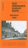

Dartford And Gravesend 1893
Dartford and Gravesend in 1893 in a series of reproductions of Ordnance Survey’s famous ”Inch to the Mile” maps published in the Alan Godfrey Editions to provide a historical record of England and Wales in the second half of 19th and early 20th century.The map covers an area from Bromley eastward to Gravesend and from Erith southward to Halsted, with north of the Thames a small portion of Essex around Tilbury and Grays. Coverage also includes: in ESSEX Chadwell St Mary`s, Grays, Little Thurrock, Purfleet, Tilbury, West Thurrock, and West Tilbury; plus in KENT Ash, Bexley, Bromley, Chalk, Charlton, Chelsfield, Chislehurst, Cobham, Crayford, Eltham, Erith, Eynsford, Farnborough, Farningham, Fawkham, Foots Cray, Greenhithe, Halsted, Hartley, Hayes, Horton
Kirkby, Keston, Kidbrooke, Kingsdown, Longfield, Luddesdown, Lullingstone, Meopham, Mottingham, North Cray, Northfleet, Nursted, Orpington, Plumstead, Ridley, Shinglewell, Shoreham, St Mary Cray, St Paul`s Cray, Stansted, Stone, Sutton at Hone, Swanley, Swanscombe, Welling, Wilmington, and Woolwich. On the reverse is a more detailed map of the centre of Betsham, including Southfleet station.*About the Alan Godfrey Editions of the OS Inch to the Mile Maps:* The maps provide an invaluable overview of a wider area, typically 18 x 12 miles (29 x 19 kms approx.), and offer historical mapping for small towns and villages not covered by the more detailed series for which the Godfrey Editions are better known. On the reverse all the maps have historical notes and most
titles also include a more detailed, large scale map of a small town or a village in the area.To see other titles in this series please click on the series link.
Product Description
Reviews/Comments
Add New
Vouchers
No voucher codes found.
Do you know a voucher code for this product or supplier? Add it to Insights for others to use.
Do you know a voucher code for this product or supplier? Add it to Insights for others to use.
 Denmark