
 United Kingdom
 France
 Germany
 Netherlands
 Sweden
 USA
USA
 Italy
Italy
 Spain
Spain
More From Contributor


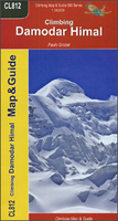
Damodar Himal
Damodar Himal on the northern edge of the Annapurna Conservation area presented by Nepa Maps at 1:50, 000 on a map extending from Phu northwards to the Gaurigi and Bhrikuti peaks and west to Muktinath and Ghiling (Geling). Contours are at 40m intervals, with heights for numerous peaks and colouring for the glaciated areas. The map highlights the trek northwards from Phu to the Gaurigi Base Camp and the Bacha Khola Camp, indicating the climbing section between the Bhrikuti Shail BC and the Japanese BC. Also marked is a small section of the Annapurna Circuit across the Thorung La Pass, plus several routes in the western half of the map between Muktinath and Kog, Tamgye, etc. Margin ticks show latitude and longitude at intervals of 2’30”. The map has no index. Map legend includes
English. The whole of the reverse side is covered by notes about the area, including lists of peaks with permit information, first ascents, etc – all the text in this edition is in French only.Titles in this Nepa Maps series have cartography is based on the country’s topographic survey, with contours usually at 40m or 50m intervals, enhanced by relief shading, colouring and graphics to show various features of the terrain, including glaciers, forested or cultivated areas, etc. Numerous peaks, with additional spot heights, plus names of glaciers and mountain ranges are prominently shown. The network of rivers, streams and lakes is shown in great detail, with many smaller rivers and lakes named. Overprint highlights main trekking routes and numerous local trails, with
symbols indicating various places of interest and tourist facilities. Most maps are indexed and include additional information such as route profiles, glossaries, etc. All the information is in English and heights are given in metres.To see other titles in this series please click in the series link.

Product Description
Reviews/Comments
Add New
Vouchers
No voucher codes found.
Do you know a voucher code for this product or supplier? Add it to Insights for others to use.
Do you know a voucher code for this product or supplier? Add it to Insights for others to use.
 Denmark