More From Contributor
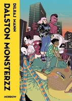
£8.99
Paper version of map No. 77 from the Ordnance Survey’s Landranger series at 1:50, 000, with contoured & GPS compatible topographic mapping plus tourist information.MOBILE DOWNLOADS: As well as the physical edition of the map, each Landranger title now

Includes::
a code for downloading after purchase its digital version onto your smartphone or tablet for viewing on the OS smartphone app.OS LANDRANGER SERIES: to see the list of all the titles in the OS Landranger series, both paper & waterproof versions, please click on the series link. Maps in the Landranger series provide plenty of recreational & tourist information, indicating the traditional public right of way paths (except in Scotland where different laws apply), including bridleways & byways restricted or open to motorized traffic. National Trails & selected other long-distance paths are marked, as well as on-road & traffic-free cycle routes with their National/ Regional Cycle Network numbers. National Trust/ National Trust for Scotland & Forestry Commission land is clearly marked, indicating open or restricted access. A range of symbols highlights camping & caravanning sites, youth hostels, tourist information offices & visitors’ centres, parking & picnicking places, World Heritage sites, sport & recreational facilities, etc. The maps provide detailed presentation of topography with contours at 10m intervals, numerous spot heights & additional colouring and/or graphics for different types of woodlands, orchards or parkl&, rock features including scree & cliffs, water features inland & along the sea shore with marshl&, dunes, s&, mud, shingle & the high water mark. All the standard information expected of survey mapping at this scale is included: finely graded road network, railway lines with stations, cuttings, embankments, etc; individual isolated buildings; archaeological & historical sites, etc. For GPS users the British National Grid is shown at 1km intervals, with latitude & longitude given by margin ticks at 1` & cross hairs on the map at 5`. Each map covers an area of 40 x 40km, (approx. 25 x 25 miles).

...
Archived Product
£19.99
The southern part of Sweden in a series of 30 double-sided cycling maps from Norstedts printed on light, waterproof & tear-resistant synthetic paper. Mainland is covered at 1:90, 000 with Gotland at 1:100, 000. The maps, prepared in association with Cykelfrämjandet
- Sweden’s largest national cycling organization, highlight all the national & other major cycle routes, plus a selection of local routes. The overprint indicates sections which are on gravel roads and/or not singposted. Also marked are selected hiking trails. A range of symbols indicate various facilities & places of interest, including campsites & youth hostels, wind shelters, cultural & historical sites, interesting nature & geological spots, etc. The maps provide a very detailed picture of the road network, including privately maintained roads open to the general public. Railway lines are shown with stations & ferry connections are marked. Topography is indicated by light relief shading with spot heights, plus colouring and/or graphics for forests & marshl&. The maps have a UTM grid, plus latitude & longitude lines at intervals of 10’. Map legend

Includes::
English. Each map also provides phone numbers & web addresses of local tourist offices.


...
Archived Product
£3.50
Dalston in 1870 in a fascinating series of reproductions of old Ordnance Survey plans in the Alan Godfrey Editions, ideal for anyone interested in the history of their neighbourhood or family. Three versions of this map cover the same area, stretching from Essex Road eastward to London Fields, & from Shacklewell Lane southward to De Beauvoir Crescent; a varied & very busy area, comprising De Beauvoir Town, Kingsland & Balls Pond at the west, Dalston & west Hackney to the east. The North London Railway forms a T-shape across the map, including Dalston Junction & Haggerston stations, while on the later maps the GER line runs down the eastern side, including London Fields & Hackney Downs stations. Kingsland Road & Kingsland High Street run north-south through the centre of the map. Other features include De Beauvoir Square, Kingsland Basin, Bricklayers Almshouses, Dyers Almshouses, Balls Pond Road, Mildmay Compound, German Hospital, Militia Barracks, etc. About the Alan Godfrey Editions of the 25” OS Series: Selected towns in Great Britain & Ireland are covered by maps showing the extent of urban development in the last decades of the 19th & early 20th century. The plans have been taken from the Ordnance Survey mapping & reprinted at about 15 inches to one mile (1:4, 340). On the reverse most maps have historical notes & many also include extracts from contemporary directories. Most maps cover about one mile (1.6kms) north/south, one & a half miles (2.4kms) across; adjoining sheets can be combined to provide wider coverage.FOR MORE INFORMATION & A COMPLETE LIST OF ALL AVAILABLE TITLES PLEASE CLICK ON THE SERIES LINK. ...
Archived Product
£3.50
Dalston in 1894 in a fascinating series of reproductions of old Ordnance Survey plans in the Alan Godfrey Editions, ideal for anyone interested in the history of their neighbourhood or family. Three versions of this map cover the same area, stretching from Essex Road eastward to London Fields, & from Shacklewell Lane southward to De Beauvoir Crescent; a varied & very busy area, comprising De Beauvoir Town, Kingsland & Balls Pond at the west, Dalston & west Hackney to the east. The North London Railway forms a T-shape across the map, including Dalston Junction & Haggerston stations, while on the later maps the GER line runs down the eastern side, including London Fields & Hackney Downs stations. Kingsland Road & Kingsland High Street run north-south through the centre of the map. Other features include De Beauvoir Square, Kingsland Basin, Bricklayers Almshouses, Dyers Almshouses, Balls Pond Road, Mildmay Compound, German Hospital, Militia Barracks, etc. About the Alan Godfrey Editions of the 25” OS Series: Selected towns in Great Britain & Ireland are covered by maps showing the extent of urban development in the last decades of the 19th & early 20th century. The plans have been taken from the Ordnance Survey mapping & reprinted at about 15 inches to one mile (1:4, 340). On the reverse most maps have historical notes & many also include extracts from contemporary directories. Most maps cover about one mile (1.6kms) north/south, one & a half miles (2.4kms) across; adjoining sheets can be combined to provide wider coverage.FOR MORE INFORMATION & A COMPLETE LIST OF ALL AVAILABLE TITLES PLEASE CLICK ON THE SERIES LINK. ...
Archived Product
£3.50
Dalston in 1913 in a fascinating series of reproductions of old Ordnance Survey plans in the Alan Godfrey Editions, ideal for anyone interested in the history of their neighbourhood or family. Three versions of this map cover the same area, stretching from Essex Road eastward to London Fields, & from Shacklewell Lane southward to De Beauvoir Crescent; a varied & very busy area, comprising De Beauvoir Town, Kingsland & Balls Pond at the west, Dalston & west Hackney to the east. The North London Railway forms a T-shape across the map, including Dalston Junction & Haggerston stations, while on the later maps the GER line runs down the eastern side, including London Fields & Hackney Downs stations. Kingsland Road & Kingsland High Street run north-south through the centre of the map. Other features include De Beauvoir Square, Kingsland Basin, Bricklayers Almshouses, Dyers Almshouses, Balls Pond Road, Mildmay Compound, German Hospital, Militia Barracks, etc. About the Alan Godfrey Editions of the 25” OS Series: Selected towns in Great Britain & Ireland are covered by maps showing the extent of urban development in the last decades of the 19th & early 20th century. The plans have been taken from the Ordnance Survey mapping & reprinted at about 15 inches to one mile (1:4, 340). On the reverse most maps have historical notes & many also include extracts from contemporary directories. Most maps cover about one mile (1.6kms) north/south, one & a half miles (2.4kms) across; adjoining sheets can be combined to provide wider coverage.FOR MORE INFORMATION & A COMPLETE LIST OF ALL AVAILABLE TITLES PLEASE CLICK ON THE SERIES LINK. ...
Archived Product
£18.99
A STORY OF CORRUPTION, EGO, GREED
- & ONE TERRIBLE MISJUDGMENT. In this jaw-dropping expose, Oliver Shah uncovers the truth
...
Archived Product
£13.99
Damaraland in Namibia at 1:430, 000 on a road map from the South African publishers International Motoring Productions, annotated with numerous GPS waypoints for selected road junctions, settlements & recommended accommodation. Coverage starts just south of Swakopmund & extends northwards to 19º, just beyond Kamanjab. Road classification indicates tarred roads, major & minor gravel roads & 4WD tracks, with driving distances marked on most routes & locations of fuel stations. GPS waypoints for road junctions are marked directly on the map; campsites & other accommodation options are named, with their GPS coordinates listed in a separate table. Symbols indicate locations with access by air and/or tourist lodges & campsites, plus various points of interest. Rather simple cartography has basic elevation tinting & occasional spot heights; seasonal rivers are marked & main mountain ranges are named. Coverage further north is provided by the publishers’ map of Kaokoland which overlaps with this title. ...
Archived Product
£5.99
Damascus in the Footprint Focus Guides, which are targeted at cities, regions & countries worldwide that have no, or very limited, coverage from other publishers. Widely recognised for their reliability & independent writing style, Footprint Focus guides all have the same layout. Smaller than their sister Handbooks, the Focus guides are intended to streamline the information contained so that you have more of what you need, without losing Footprint ...
Archived Product
£12.50
When Peter Clark arrived in Damascus 1992 to open the new British Council office, he was not to know that the next five years were to give him an unique window on the upper echelons of Syrian society in the last few years of Hafez Al-Assad`s rule. Here we see the dramas & routines of everyday life played out against the backdrop of the world`s oldest continually inhabited city on the eve of collapse into civil war. Enchanting & alarming by turns, everyday events combine to paint a vivid & almost nostalgic picture of life in this remarkable city. ...
Archived Product
£7.99
Salim the coachman tells enchanting tales, but suddenly he is struck dumb. Just as Scheherazade told tales to save her life, Salim's friends must spin yarns to save his speech. Set in Damascus in 1959, the novel alternates the real lives of our storytellers with stories from the distant past. These are neither fables nor fairy tales with everlasting, happy endings, & they often require readers to suspend their disbelief. Each chapter is preceded by a one-line hint of what is to come, such as ' How one person's true story was not believed, whereas his most blatant lie was.' ...
Archived Product

Dalston Monsterzz

In Dilraj Mann`s long awaited graphic novel debut, all eyes turn to East London, where freakish monsters and megalomanical property developers are competing to see who can destroy it first. The only thing that stands in the way of the apocalypse? Hipsters, hotties, and nerds. It`s time to throw down--and look sharp as hell while doing so.
RIP - This product is no longer available on our network. It was last seen on 25.09.2019

This page now acts as a permanent archive for this product. Add more information using the comments box below to ensure it can still be found by future generations.

Use our search facility to see if it is available from an alternative contributor.
  • External links may include paid for promotion
  • Availability: Out Of Stock
  • Supplier: Stanfords
  • SKU: 9781910620359
Availability: In Stock
£14.99

Product Description

In Dilraj Mann`s long awaited graphic novel debut, all eyes turn to East London, where freakish monsters & megalomanical property developers are competing to see who can destroy it first. The only thing that stands in the way of the apocalypse? Hipsters, hotties, & nerds. It`s time to throw down--and look sharp as hell while doing so.

Reviews/Comments

Add New

Intelligent Comparison

Oooops!
We couldn't find anything!
Perhaps this product's unique.... Or perhaps we are still looking for comparisons!
Click to bump this page and we'll hurry up.

Price History

Vouchers

No voucher codes found.
Do you know a voucher code for this product or supplier? Add it to Insights for others to use.

Facebook

Jargon Buster

Supplier Information

Stanfords
Stanfords was established in 1853 and opened their iconic Covent Garden flagship store in 1901. They have become the top retailer of maps, travel books and accessories in the UK and arguably offer the largest selection of maps and travel books worldwide. Famous names such as Captain Robert Falcon Scott, Ranulph Fiennes and Michael Palin have purchased from Stanfords. They now have a shop in Bristol and both stores together with other venues operate a calendar of events including talks, book signings and exhibitions. As a specialist map retailer, the map selection is comprehensive and includes road maps, street maps and walking maps from worldwide destinations, as well as a selection of world atlases and wall maps. Books include travel guides and travel literature. Stanfords also stock globes, from miniatures made of blue marble to magnificent floor-standing globes. The website features a selection of interesting articles on travel topics.
Page Updated: 2023-11-12 20:15:36

Community Generated Product Tags

Oh No! The productWIKI community hasn't generated any tags for this product yet!
Menu