More From Contributor
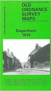
£12.99
The ultimate family activity guide for busy daring dads in need of a little inspiration to spend quality time with their kids, by double Olympic gold medallist rower, adventurer & father of three, Alex Gregory. ` Time is the one resource we can`t buy but we all want. It`s so important to make the most of the time we have & create lasting memories.` For a parent, leaving the house can sometimes be the hardest part. But outside is where adventures & memories are waiting to be made... From after-school adventures to an overnight trip, double Olympic gold medallist rower & father-of-three Alex Gregory shares exciting ideas for enjoying time together as a family, in all seasons. Whether you have 30 minutes to do homework up a tree, or a whole day to build an ancient bridge, you can delve in together & be inspired by this practical, easy guide for all ages. Divided into categories to fit whatever time slots work within the day, the book contains chapters such as After-School Adventures, 30-Minute Activities, Two-Hour Missions, Half-Day Experiences, Full-Day Adventures, Overnight Expeditions & Pushing Away from L&. No matter how much time you have, make it count with ` Dadventures`
- the ultimate guide to ditching the routine & having fun with your kids.
...
Archived Product
£20.00
In over 30 essays, written over 20 years, one of the world`s great story-tellers meditates on story-telling. Warm, funny, generous, entertaining &, above all, deeply considered, they offer thoughts on a wide variety of topics, including the origin & composition of Philip`s own stories, the craft of writing & the story-tellers who have meant the most to Philip. The art of story-telling is everywhere present in the essays themselves, in the instantly engaging tone, the vivid imagery & striking phrases, the resonant anecdotes, the humour & learnedness. Together, they are greater than the sum of their parts: a single, sustained engagement with story & story-telling. ...
Archived Product
£18.99
A beautifully illustrated, visually lush & intriguing book about the world`s most popular & most powerful flower. The daffodil is the beautiful first flower of spring, the inspiration of poets, a treasure-trove to scientists & a symbol of everything from unrequited love, rebirth, eternal life & misfortune. Over centuries, the daffodil has been so many things to so many people: it was called ` Narcissus` by the Greeks & prized by the Romans as guarantee of passage to the Underworld; it was used by medieval Arabs & ancient Chinese for its medicinal properties & it has inspired poets, lovers, artists & scientists down the ages. But in telling the story of the daffodil, what award-winning, best-selling writer Helen O` Neill is really telling is the story of humanity. It`s a narrative of progress from superstition & myth, taking in politics, greed, religion, science, chance, redemption & love. But, appropriately enough for a flower that is now used on a worldwide basis to raise funds for cancer research, it is, above all, a story of hope. Moving, fascinating, eloquent, & also beautiful.`O` Neill manages to make a biography of a flower feel like something of a detective novel, love story, historical drama & horticultural research paper rolled into one` Sydney Morning Herald ...
Archived Product
£20.00
The aim of this book is to enable novices to cruise safely & enjoyably. It will cover the preparations needed before undertaking a cruise, operating the boat under different & sometimes challenging conditions, advise how to cope when things go wrong, how to conform to the rules & regulations, & how to navigate in all conditions. It presents the advice & information in just the same way that the cruiser will encounter the situations on passage
- from setting off to arriving at their destination. Topics include: Preparing to cruise (weather forecasts, route planning, checklists); Leaving harbour (harbour entrances, setting courses & speeds, crew briefing, food & drink); Assessing weather & sea conditions (fine tuning your plans); Watch keeping under way (visual & electronic navigation, coping with alarms); Entering harbour (planning ahead, radio channels, finding an anchorage, speeds); Cruising at night & in fog (lights, radar, shipping lanes, stopping distance); Adventurous cruising (navigating inshore, beach landing, hidden dangers); Fuel management & economy (economical speeds, boat trim, reserves); Comfort on board (cooking & sleeping at sea, security); When things go wrong (potential problems, safety equipment, coping with fire, leaks, grounding, engine problems, calling for help); Rules & regulations (collision regulations, traffic lanes, going foreign, qualifications). Aimed at owners of powerboats & motor cruisers between 25 & 65ft, the book is entirely practical, with checklists, sidebars, box-outs, many diagrams & is illustrated with superb action photos.
...
Archived Product
£20.00
Many sailboat owners undertake cruises in their boats, travelling from one port to another, sometimes on a day trip & sometimes for a week or two. The aim of this book is to give novices the information to cruise safely & enjoyably, covering:
- the preparations before setting off
- assessing the sea & weather conditions
- briefing the crew
- navigating
- coping when things go wrong
- operating the boat under different & sometimes challenging conditions
- conforming with rules & regulations With advice, hints, tips & personal anecdotes, this is a very practical book
- rather than being compartmentalized into sections on weather/navigation etc, it accompanies the cruiser from departure to their safe arrival at their destination, drawing out the practical lessons at each stage of the passage from the theory found in text books. The superb photography illustrates the text & will inspire sailors of all levels.


...
Archived Product
£30.00
Daghestan is home to more than 30 distinct peoples. Each has their own language yet they share a surprisingly homogeneous culture that has both withstood & absorbed centuries of external influences. A fascinating account of change & adaptation in the villages of this area. ...
Archived Product
£9.99
Dahme – Spree on a waterproof, tear-resistant, GPS compatible cycling map at 1:75, 000 from the ADFC (Allgemeiner Deutscher Fahrrad-Club
-
...
Archived Product
£12.99
In this portrait of life in Ancient Rome, the author begins by painting a backcloth on which the social, political, cultural & religious aspects of the community are drawn. He enlarges on the details of everyday life, following the typical routine of a normal day from dawn to dinner & the talk that continued long into the night. This study, which

Includes::
a bibliography & notes by Professor Rowell, describes the houses & multi-storeyed apartments of the city of over a million inhabitants, the social classes from senators to slaves & the Roman family & the position of women.

...
Archived Product
£5.99
Single-sided, folded World Political Map at 1:35, 000, 000 from Insight in conjunction with the Daily Mail. Atlantic-centred, with flags, country information, shipping lanes & some physical information. The cartography shows countries using subtle colours, clear & unobtrusive names & national borders. Internal administrative divisions & the names of these units are shown for some larger countries, such as Brazil, Australia, India, China & the United States. Overseas territories appear with names of sovereign states in brackets. Capitals & major towns & cities are shown with an indication of population size. Important airports & harbours are marked & international shipping lanes are indicated with distances. Faint dotted lines highlight main railway lines. Some physical features are shown, such as light relief shading & names for major mountain ranges, spot heights & names of major peaks, & the courses of major rivers. Surrounding the map itself is a list of country profiles organised by continent, which acts an index to the location of the countries on the map. Each country profile

Includes::
a national flag, the local name (in Roman script), the English name, the country's surface area, capital, government system, administrative divisions, population, main languages & religions, GDP per capita & currency. There are additional lists of world records such as the largest countries & cities, the tallest buildings & the wealthiest nations. The map uses a Mercator projection at a scale of 1:35, 000, 000 at the Equator, with latitude & longitude lines drawn at intervals of 15

...
Archived Product
£8.99
` Utterly fascinating` Daisy Goodwin, Sunday Times Anthony Trollope wrote three thousand words every morning before heading off to his job at the Post Office. Toulouse-Lautrec did his best work at night, sometimes even setting up his easel in brothels, & George Gershwin composed at the piano in pyjamas & a bathrobe. Freud worked sixteen hours a day, but Gertrude Stein could never write for more than thirty minutes, & F. Scott Fitzgerald wrote in gin-fuelled bursts
- he believed alcohol was essential to his creative process. From Marx to Murakami & Beethoven to Bacon, Daily Rituals examines the working routines of more than a hundred & sixty of the greatest philosophers, writers, composers & artists ever to have lived. Filled with fascinating insights on the mechanics of genius & entertaining stories of the personalities behind it, Daily Rituals is irresistibly addictive, & utterly inspiring.
...
Archived Product

Dagenham 1915

Dagenham in 1915 in a fascinating series of reproductions of old Ordnance Survey plans in the Alan Godfrey Editions, ideal for anyone interested in the history of their neighbourhood or family. The map covers the village of Dagenham where development was at an early stage. The LTS railway runs west-east across the map, with Dagenham (later Dagenham East) station, crossed by Romford Road / Bull Street running north-south. Features include St Peter & St Paul`s church, Ford`s School, Romford UDC sewage farm, and Bretons at the eastern edge. The beginnings of industry are shown by Sterling Telephone Works on the land of Wantz Farm. On the reverse is a railway timetable for the LTS line in 1929.About the Alan Godfrey Editions of the 25” OS Series:Selected towns in Great Britain and
Ireland are covered by maps showing the extent of urban development in the last decades of the 19th and early 20th century. The plans have been taken from the Ordnance Survey mapping and reprinted at about 15 inches to one mile (1:4, 340). On the reverse most maps have historical notes and many also include extracts from contemporary directories. Most maps cover about one mile (1.6kms) north/south, one and a half miles (2.4kms) across; adjoining sheets can be combined to provide wider coverage.FOR MORE INFORMATION AND A COMPLETE LIST OF ALL AVAILABLE TITLES PLEASE CLICK ON THE SERIES LINK.
RIP - This product is no longer available on our network. It was last seen on 25.09.2019

This page now acts as a permanent archive for this product. Add more information using the comments box below to ensure it can still be found by future generations.

Use our search facility to see if it is available from an alternative contributor.
  • External links may include paid for promotion
  • Availability: Out Of Stock
  • Supplier: Stanfords
  • SKU: 9780850545685
Availability: In Stock
£3.50

Product Description

Dagenham in 1915 in a fascinating series of reproductions of old Ordnance Survey plans in the Alan Godfrey Editions, ideal for anyone interested in the history of their neighbourhood or family. The map covers the village of Dagenham where development was at an early stage. The LTS railway runs west-east across the map, with Dagenham (later Dagenham East) station, crossed by Romford Road / Bull Street running north-south. Features include St Peter & St Paul`s church, Ford`s School, Romford UDC sewage farm, & Bretons at the eastern edge. The beginnings of industry are shown by Sterling Telephone Works on the land of Wantz Farm. On the reverse is a railway timetable for the LTS line in 1929. About the Alan Godfrey Editions of the 25” OS Series: Selected towns in Great Britain & Ireland are covered by maps showing the extent of urban development in the last decades of the 19th & early 20th century. The plans have been taken from the Ordnance Survey mapping & reprinted at about 15 inches to one mile (1:4, 340). On the reverse most maps have historical notes & many also include extracts from contemporary directories. Most maps cover about one mile (1.6kms) north/south, one & a half miles (2.4kms) across; adjoining sheets can be combined to provide wider coverage.FOR MORE INFORMATION & A COMPLETE LIST OF ALL AVAILABLE TITLES PLEASE CLICK ON THE SERIES LINK.

Reviews/Comments

Add New

Price History

Vouchers

No voucher codes found.
Do you know a voucher code for this product or supplier? Add it to Insights for others to use.

Facebook

Jargon Buster

Contemporary - Modern era design
Contemporary - A design reference to indicate post war modern design
History - Anything that happens in the past. An acedemic subject.
Telephone - A device used for communicating audio over long distances
running - A sport or hobbie of moving rapidly on foot. Can also refer to the running of equipment or run time refering to the length of time an applicance can run or the quiet running of an applicance.
edge - Enhanced data rates for GSM evolution also known as enhanced GPRS. A mobile phone technology with improved data transmission rates.
edge - The point at which two surfaces meet
Road - a manmade lane or a path that is used to speed up travel.
Contemporary - An object that is living in the same time.
Ideal - Something that satisfies a perfect criteria.
Family - A group of people that live together made up from parents and children.

Supplier Information

Stanfords
Stanfords was established in 1853 and opened their iconic Covent Garden flagship store in 1901. They have become the top retailer of maps, travel books and accessories in the UK and arguably offer the largest selection of maps and travel books worldwide. Famous names such as Captain Robert Falcon Scott, Ranulph Fiennes and Michael Palin have purchased from Stanfords. They now have a shop in Bristol and both stores together with other venues operate a calendar of events including talks, book signings and exhibitions. As a specialist map retailer, the map selection is comprehensive and includes road maps, street maps and walking maps from worldwide destinations, as well as a selection of world atlases and wall maps. Books include travel guides and travel literature. Stanfords also stock globes, from miniatures made of blue marble to magnificent floor-standing globes. The website features a selection of interesting articles on travel topics.
Page Updated: 2023-11-12 20:15:36

Community Generated Product Tags

Oh No! The productWIKI community hasn't generated any tags for this product yet!
Menu