More From Contributor
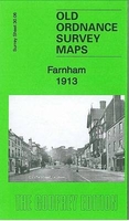
£12.00
First published in 1932 & written in simple, direct prose, Farmer`s Glory is a portrait of a farming life in southern England & in western Canada, & is a model of the genre: warm & humorous as well as an astute & unflinching account of the hardships of a farming life. Introduced, in this new, edition by James Rebanks, bestselling author of The Shepherd`s Life. ...
Archived Product
£6.50
Farmington, NM
- Durango, CO
- Cortez, CO in a series of indexed street plans of US cities from G.M. Johnson & Associates.

...
Archived Product
£17.99
This is a br&-new & exciting interactive title in the popular ” Farmyard Tales” series. Three tractor stories are retold with a new twist! Each story has a sturdy track embedded in the pages which the accompanying wind-up tractor toy can then be placed upon to follow around & bring the story to life. It also

Includes::
pop-out models of all the favourite ” Farmyard Tales” characters which slot firmly into the spaces around the track to complete the scenes. It is a fantastic gift which is guaranteed to engage & entertain young children.

...
Archived Product
£2.95
Farnborough in 1930 in a fascinating series of reproductions of old Ordnance Survey plans in the Alan Godfrey Editions, ideal for anyone interested in the history of their neighbourhood or family. Selected towns in Great Britain & Ireland are covered by maps showing the extent of urban development in the last decades of the 19th & early 20th century. In this title: the map is double-sided. The main map covers the area from St John's church West Heath eastward to St Michael's Abbey, & from Farnborough Hill Convent School southward to Hillside College. Features include Cove, Cove Bungalows, Rafborough, Cove Green, Pinehurst Barracks, station, military line (closed 1968), North Farnborough, Forest Lodge, Tumble Down Dick Hotel. On the reverse is part of the adjacent sheet 13.14 extending coverage eastward to the county boundary. Features here include Farnborough Park, Avenue Road, Farnborough Court & the southern part of the area known as Farnborough Street. About the Alan Godfrey Editions of the 25 ...
Archived Product
£3.50
Farnborough in 1930 in a fascinating series of reproductions of old Ordnance Survey plans in the Alan Godfrey Editions, ideal for anyone interested in the history of their neighbourhood or family. The map is double-sided: the main map covers the area from St John`s church West Heath eastward to St Michael`s Abbey, & from Farnborough Hill Convent School southward to Hillside College. Features include Cove, Cove Bungalows, Rafborough, Cove Green, Pinehurst Barracks, station, military line (closed 1968), North Farnborough, Forest Lodge, Tumble Down Dick Hotel. On the reverse is part of the adjacent sheet 13.14 extending coverage eastward to the county boundary. Features here include Farnborough Park, Avenue Road, Farnborough Court & the southern part of the area known as Farnborough Street. About the Alan Godfrey Editions of the 25” OS Series Selected towns in Great Britain & Ireland are covered by maps showing the extent of urban development in the last decades of the 19th & early 20th century. The plans have been taken from the Ordnance Survey mapping & reprinted at about 15 inches to one mile (1:4, 340). On the reverse most maps have historical notes & many also include extracts from contemporary directories. Most maps cover about one mile (1.6kms) north/south, one & a half miles (2.4kms) across; adjoining sheets can be combined to provide wider coverage.FOR MORE INFORMATION & A COMPLETE LIST OF ALL AVAILABLE TITLES PLEASE CLICK ON THE SERIES LINK. ...
Archived Product
£3.50
Farnworth in 1908 in a fascinating series of reproductions of old Ordnance Survey plans in the Alan Godfrey Editions, ideal for anyone interested in the history of their neighbourhood or family. The map covers much of the Lancashire town of Farnworth. Coverage stretches from Dixon Green eastward to Clamourclough Mill, & from Bentley Street southward to Lark Hill. Features include Farnworth station, tramways & depot, Farnworth Park, Darley Hall, Darley Hall Pottery, St John`s church, Limefield Mill, Clamourclough Tunnel, Pandora Mills, Causeway Mills, Egyptian Mills, Oak Mills, Drake Mill, Marvels Brow Oil Works, Market Place, Dixon Green Mill, New Bury, Century Mill, Harrowby Mills, Albert Mills, numerous smaller mills, etc. A Farnworth commercial directory, entries A to R, is on the reverse. About the Alan Godfrey Editions of the 25” OS Series: Selected towns in Great Britain & Ireland are covered by maps showing the extent of urban development in the last decades of the 19th & early 20th century. The plans have been taken from the Ordnance Survey mapping & reprinted at about 15 inches to one mile (1:4, 340). On the reverse most maps have historical notes & many also include extracts from contemporary directories. Most maps cover about one mile (1.6kms) north/south, one & a half miles (2.4kms) across; adjoining sheets can be combined to provide wider coverage.FOR MORE INFORMATION & A COMPLETE LIST OF ALL AVAILABLE TITLES PLEASE CLICK ON THE SERIES LINK. ...
Archived Product
£17.99
Topographic survey of Portugal at 1:50, 000 from the Instituto Geográfico do Exército, the country’s military survey organisation. The maps have contours at 20m intervals & in addition to the standard features shown on topographic mapping at this scale also indicate various types of terrain or vegetation (s&, terraces, rocks, woodlands, vineyards, etc). Each sheet covers an area of 32 x 20km (20 x 12.5 miles approx). The maps have a 1-km UTM grid plus latitude & longitude coordinates for the map corners. Map legend & a glossary of terms used on the maps include English.EDITION DATES: most titles in this series date from 1990s or later. To see all the titles in this series please click on the series link. ...
Archived Product
£17.99
Topographic survey of Portugal at 1:100, 000 from the Instituto Geográfico Português, the country’s civilian survey organisation. The maps have contours at 50m intervals & in addition to the standard features shown on topographic mapping at this scale also indicate various types of vegetation (vineyards, olive groves, etc). Each sheet covers an area of 64 x 40km (40 x 25 miles approx). The maps have latitude & longitude margin ticks at 1’ intervals, plus show UTM coordinates for the map corners. Map legend is in Portuguese only.PLEASE NOTE
- EDITION DATES: some sheets at this scale date back to the 1950s or 1960s. For more recent editions please see IGP’s 1:25, 000 series where each 50K map is divided into four quarters. To see all the titles in the 1:100, 000 series please click on the series link.
...
Archived Product
£17.99
Topographic survey of Portugal at 1:50, 000 from the Instituto Geográfico Português, the country’s civilian survey organisation. The maps have contours at 25m intervals & in addition to the standard features shown on topographic mapping at this scale also indicate various types of vegetation (vineyards, olive groves, etc). Each sheet covers an area of 32 x 20km (20 x 12.5miles approx). The maps have latitude & longitude margin ticks at 1’ intervals & UTM coordinates for the map corners – each sheet also shows conversion details from BBLx (Bessel-Bonnie system, Datum Lisbon) to UTM. Map legend is in Portuguese only.EDITION DATES: most titles in this series have now been updated in the 1990s or later. To see all the titles in this series please click on the series link. ...
Archived Product
£25.00
We are able to source a wide range of courtesy flags. Flags are available in many sizes & can be sewn or printed on 100% Ministry Of Defence Standard Woven & Knitted Polyester. Flags are supplied with rope & toggle. If you would like more information, have a custom size request or cannot find a desired product, please email us at maritime@stanfords.co.uk. We will be glad to help! ...
Archived Product

Farnham 1913

Farnham in 1913 in a fascinating series of reproductions of old Ordnance Survey plans in the Alan Godfrey Editions, ideal for anyone interested in the history of their neighbourhood or family. The map is double-sided for maximum coverage; the main map covers the centre of the town extending southward to Searle Road and Cromwell Avenue. Features include railway with station, St Andrew`s church, Fir Grove, Vernon House, Weydonhill Farm, Fairfield area, Town Hall, Castle, Emmanuel church, malthouses, Waverley Estate, Culverlands, Hatch Mill, Windsor almshouses, St James`s church, etc. On the reverse is an extract from the adjacent sheet 30.02, extending coverage northward to include Farnham Park, workhouse, Bourne Mill, etc. About the Alan Godfrey Editions of the 25” OS
Series:Selected towns in Great Britain and Ireland are covered by maps showing the extent of urban development in the last decades of the 19th and early 20th century. The plans have been taken from the Ordnance Survey mapping and reprinted at about 15 inches to one mile (1:4, 340). On the reverse most maps have historical notes and many also include extracts from contemporary directories. Most maps cover about one mile (1.6kms) north/south, one and a half miles (2.4kms) across; adjoining sheets can be combined to provide wider coverage.FOR MORE INFORMATION AND A COMPLETE LIST OF ALL AVAILABLE TITLES PLEASE CLICK ON THE SERIES LINK.
RIP - This product is no longer available on our network. It was last seen on 25.09.2019

This page now acts as a permanent archive for this product. Add more information using the comments box below to ensure it can still be found by future generations.

Use our search facility to see if it is available from an alternative contributor.
  • Availability: Out Of Stock
  • Supplier: Stanfords
  • SKU: 9781847848468
Availability: In Stock
£3.50

Product Description

Farnham in 1913 in a fascinating series of reproductions of old Ordnance Survey plans in the Alan Godfrey Editions, ideal for anyone interested in the history of their neighbourhood or family. The map is double-sided for maximum coverage; the main map covers the centre of the town extending southward to Searle Road & Cromwell Avenue. Features include railway with station, St Andrew`s church, Fir Grove, Vernon House, Weydonhill Farm, Fairfield area, Town Hall, Castle, Emmanuel church, malthouses, Waverley Estate, Culverlands, Hatch Mill, Windsor almshouses, St James`s church, etc. On the reverse is an extract from the adjacent sheet 30.02, extending coverage northward to include Farnham Park, workhouse, Bourne Mill, etc. About the Alan Godfrey Editions of the 25” OS Series: Selected towns in Great Britain & Ireland are covered by maps showing the extent of urban development in the last decades of the 19th & early 20th century. The plans have been taken from the Ordnance Survey mapping & reprinted at about 15 inches to one mile (1:4, 340). On the reverse most maps have historical notes & many also include extracts from contemporary directories. Most maps cover about one mile (1.6kms) north/south, one & a half miles (2.4kms) across; adjoining sheets can be combined to provide wider coverage.FOR MORE INFORMATION & A COMPLETE LIST OF ALL AVAILABLE TITLES PLEASE CLICK ON THE SERIES LINK.

Reviews/Comments

Add New

Intelligent Comparison

Oooops!
We couldn't find anything!
Perhaps this product's unique.... Or perhaps we are still looking for comparisons!
Click to bump this page and we'll hurry up.

Price History

Vouchers

No voucher codes found.
Do you know a voucher code for this product or supplier? Add it to Insights for others to use.

Facebook

Jargon Buster

Contemporary - Modern era design
Contemporary - A design reference to indicate post war modern design
History - Anything that happens in the past. An acedemic subject.
Road - a manmade lane or a path that is used to speed up travel.
Contemporary - An object that is living in the same time.
Mill - A building which can grind grain into flour.
Hall - A room at the inside of an entrance of a house.
Estate - A group of houses on the same land or area.
Ideal - Something that satisfies a perfect criteria.
Family - A group of people that live together made up from parents and children.

Supplier Information

Stanfords
Stanfords was established in 1853 and opened their iconic Covent Garden flagship store in 1901. They have become the top retailer of maps, travel books and accessories in the UK and arguably offer the largest selection of maps and travel books worldwide. Famous names such as Captain Robert Falcon Scott, Ranulph Fiennes and Michael Palin have purchased from Stanfords. They now have a shop in Bristol and both stores together with other venues operate a calendar of events including talks, book signings and exhibitions. As a specialist map retailer, the map selection is comprehensive and includes road maps, street maps and walking maps from worldwide destinations, as well as a selection of world atlases and wall maps. Books include travel guides and travel literature. Stanfords also stock globes, from miniatures made of blue marble to magnificent floor-standing globes. The website features a selection of interesting articles on travel topics.
Page Updated: 2023-11-12 20:15:36

Community Generated Product Tags

Oh No! The productWIKI community hasn't generated any tags for this product yet!
Menu