More From Contributor
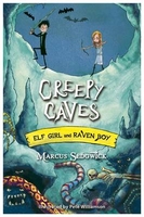
£9.99
The latest in our creative writing series is a colourful & engaging reference book, rather than a write-in book, designed to appeal to creative writers from age 9 to 99. The book is divided into sections covering different aspects of the writing process
- coming up with ideas, planning, punctuation & grammar
- as well as advice on different forms of writing, including stories, blogs, non-fiction & poetry. Throughout, there are helpful tips & suggestions, internet links "ations from well known authors to illustrate different writing techniques Illustrations: Full colour throughout

...
Archived Product
£10.99
Vibrantly illustrated by new talent Natasha Durley, this is an animal book with a difference. Each page is bursting with unusual creatures all united by a common characteristic. From enormous ears to humongous horns, & from elephants to earwigs, this eclectic collection of animals celebrates the diversity of the animal kingdom. & with something to look for on every page, it`s guaranteed to inspire & fascinate young animal lovers. ...
Archived Product
£8.99
Following the success of Creaturepedia, Adrienne Barman returns with this companion colour & activity book, bursting with rainy-day activities. Informative & fun, this book is filled with facts, creatures to color in, 100 stickers & a double gatefold poster at the rear. ...
Archived Product
£3.50
Creekmouth in 1894 in a fascinating series of reproductions of old Ordnance Survey plans in the Alan Godfrey Editions, ideal for anyone interested in the history of their neighbourhood or family. Two versions cover the area centred on Barking Creek, where the River Roding meets the Thames. At the time Creekmouth was described as ”an isolated hamlet of Barking
- seldom visited by ordinary visitors or noticed by historians”. Much is marshl&, but the left side of the map does include a significant part of the vast Beckton Gas Works, with its many sidings, etc, & Beckton Pier. There are chemical works east of the Creek & small communities at Creekmouth & Gallions Cottages. On the reverse the 1894 map has an Inch to the Mile Map from c.1870, covering the area from Plaistow, Wanstad, Woodford, Loughton & Buckhurst Hill eastward to Billericay, including Barking, Ilford, Romford, Brentwood, Rainham, Dagenham, Orsett, Havering atte Bower, Chigwell, Mountnessing, Hornchurch & Horndon on the Hill. About the Alan Godfrey Editions of the 25” OS Series: Selected towns in Great Britain & Ireland are covered by maps showing the extent of urban development in the last decades of the 19th & early 20th century. The plans have been taken from the Ordnance Survey mapping & reprinted at about 15 inches to one mile (1:4, 340). On the reverse most maps have historical notes & many also include extracts from contemporary directories. Most maps cover about one mile (1.6kms) north/south, one & a half miles (2.4kms) across; adjoining sheets can be combined to provide wider coverage.FOR MORE INFORMATION & A COMPLETE LIST OF ALL AVAILABLE TITLES PLEASE CLICK ON THE SERIES LINK.
...
Archived Product
£3.50
Creekmouth in 1914 in a fascinating series of reproductions of old Ordnance Survey plans in the Alan Godfrey Editions, ideal for anyone interested in the history of their neighbourhood or family. Two versions cover the area centred on Barking Creek, where the River Roding meets the Thames. Features include Beckton Gas Works, with its many sidings & Beckton Pier, chemical works east of the Creek & small communities at Creekmouth & Gallions Cottages. In the notes on the 1914 map Tony Clifford tells how in 1909 Frederick Handley Page was using Creekmouth for an experimental aircraft factory. About the Alan Godfrey Editions of the 25” OS Series: Selected towns in Great Britain & Ireland are covered by maps showing the extent of urban development in the last decades of the 19th & early 20th century. The plans have been taken from the Ordnance Survey mapping & reprinted at about 15 inches to one mile (1:4, 340). On the reverse most maps have historical notes & many also include extracts from contemporary directories. Most maps cover about one mile (1.6kms) north/south, one & a half miles (2.4kms) across; adjoining sheets can be combined to provide wider coverage.FOR MORE INFORMATION & A COMPLETE LIST OF ALL AVAILABLE TITLES PLEASE CLICK ON THE SERIES LINK. ...
Archived Product
£11.99
This is a new rhyming read-aloud from the beloved Jane Yolen about the snarfing, growling, hip-hopping way that monsters go to bed. Creep, gurgle, crawl, tumble! Meet two young monsters who are far from scary
- they`re too busy having fun! They go to school, play outside with their friends & eat after-school snacks. But like human children they also have a bedtime, whether they`re ready for it or not! Young children & parents alike will find much to identify with as they follow these lovable little monsters getting ready for bed. With wildly colourful illustrations full of whimsy & warmth, Kelly Murphy brings Jane Yolen`s gently rhyming tale to rip-roaring life. This is a great read-aloud for bedtime. It is a brilliant, fun book
- especially for boys! It features bright, exuberant illustrations by Kelly Murphy in her signature style.

...
Archived Product
£7.95
Cremona on an indexed street plan at 1:7, 000 from Litografia Artistica Cartografica. 35 monuments including historic buildings & churches, cultural or educational institutions, & important municipal buildings or facilities are numbered & listed next to the plan. Litografia Artistica Cartografica (LAC) are Italy ...
Archived Product
£12.99
Cremona Province at 1:150, 000 in a series of handy size provincial road maps from Litografia Artistica Cartografica (LAC) with more minor local roads & country tracks than can be found on most regional maps from other publishers. This title is published with the traditional style LAC cartography.LAC’s provincial series is gradually being changed to a new style of digitally derived cartography, so presentation of adjoining titles may vary. All the maps have hill shading to represent the general relief with spot heights for selected peaks, & show a few more local roads & rough tracks than the other road map series. Intermediate road distances are indicated. Regional, provincial & communal borders are marked, & railways, funiculars, airports, sea ferry links & campsites are shown. The legend is in Italian only. The new, digitally produced editions are indexed & have enhanced, more finely drawn cartography: the hill-shading is less bold, motorway service areas are marked, natural parks are highlighted & an expanded range of symbols indicates various landmarks & sites, e.g. antiquities, churches, etc. Two styles of the new cartography are produced, differing only in the colour of the predominant background shading: grey or yellow/green. Some of the new editions include geographical coordinates for the map corners. The index of localities is on the reverse. To see all the titles in this series please click on the series link. ...
Archived Product
£19.95
” Creole” is a sumptuous celebration of this unique & much-loved style of cooking. The heritage of French, Spanish & African settlers, Creole cookery takes the best of these cuisines & combines them with native American ingredients to produce a style of cooking that is rich in history & full of flavour. Containing over 160 recipes & including some of the most famous West Indian Creole dishes, from fish & shellfish dishes to cooling punches & frappes, ” Creole” paints an evocative picture of the food in Guadeloupe & is bursting with the sun, freshness & energy of the Caribbean. ...
Archived Product
£4.50
Heraklion Prefecture of Crete on a road map at 1:150, 000 from the Athens-based Terrain Editions, highlighting scenic routes, campsites, archaeological remains & other places of interest. On the reverse a town centre street plan of Heraklion/ Iraklion, mainly the area within the old city walls. Coverage along the south coast

Includes::
the archaeological sites of Phaestos & Aghia Triada, as well as the resorts of Matala & Aghia Galini. Maps in this series present Crete’s topography by satellite-based relief shading, with spot heights for selected peaks. Road network indicates dirt roads & shows driving distances on main & on selected secondary routes. Scenic roads are prominently highlighted, as are locations of particular interest. Also marked are campsites, mountain refuges, archaeological sites, castles & monasteries, etc. All place names are in both Greek & Latin alphabets. The maps have a UTM grid, plus latitude & longitude crosshairs at 4’. Map legend

Includes::
English. On the reverse each title has a city centre street plan of its main town, indicating important buildings & facilities, including selected hotels, museums, banks, etc. One way streets are marked, also car parks, petrol stations & car repairs workshops. Main streets are in both Greek & Latin alphabet; smaller streets in Greek only. To see the list of the titles in this series please click on the series link.


...
Archived Product

Creepy Caves

Nothing can stand in the way of Elf Girl and Raven Boy saving the world...Well, almost nothing. Just a sea monster, a dragon, and rivers of molten lava. Not to mention some seriously Creepy Caves. Defeating the Goblin King might be harder than they thought. The sixth laugh-out-loud adventure from Marcus Sedgwick and Pete Williamson.
RIP - This product is no longer available on our network. It was last seen on 25.09.2019

This page now acts as a permanent archive for this product. Add more information using the comments box below to ensure it can still be found by future generations.

Use our search facility to see if it is available from an alternative contributor.
  • External links may include paid for promotion
  • Availability: Out Of Stock
  • Supplier: Stanfords
  • SKU: 9781444005288
Availability: In Stock
£6.99

Product Description

Nothing can stand in the way of Elf Girl & Raven Boy saving the world... Well, almost nothing. Just a sea monster, a dragon, & rivers of molten lava. Not to mention some seriously Creepy Caves. Defeating the Goblin King might be harder than they thought. The sixth laugh-out-loud adventure from Marcus Sedgwick & Pete Williamson.

Reviews/Comments

Add New

Intelligent Comparison

Oooops!
We couldn't find anything!
Perhaps this product's unique.... Or perhaps we are still looking for comparisons!
Click to bump this page and we'll hurry up.

Price History

Vouchers

No voucher codes found.
Do you know a voucher code for this product or supplier? Add it to Insights for others to use.

Facebook

Jargon Buster

World - A physical grouping, commonly used to describe earth and everything associated with ti
King - The figure head of a monarch
Adventure - an undertaking of an exciting challenge or experience.

Supplier Information

Stanfords
Stanfords was established in 1853 and opened their iconic Covent Garden flagship store in 1901. They have become the top retailer of maps, travel books and accessories in the UK and arguably offer the largest selection of maps and travel books worldwide. Famous names such as Captain Robert Falcon Scott, Ranulph Fiennes and Michael Palin have purchased from Stanfords. They now have a shop in Bristol and both stores together with other venues operate a calendar of events including talks, book signings and exhibitions. As a specialist map retailer, the map selection is comprehensive and includes road maps, street maps and walking maps from worldwide destinations, as well as a selection of world atlases and wall maps. Books include travel guides and travel literature. Stanfords also stock globes, from miniatures made of blue marble to magnificent floor-standing globes. The website features a selection of interesting articles on travel topics.
Page Updated: 2023-11-12 20:15:36

Community Generated Product Tags

Oh No! The productWIKI community hasn't generated any tags for this product yet!
Menu