
 United Kingdom
 France
 Germany
 Netherlands
 Sweden
 USA
USA
 Italy
Italy
 Spain
Spain
More From Contributor

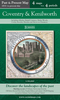


Coventry C.1804-1810
Coventry, an original antique map by G.Cole / J.Roper, published in London, c. 1804 -1810. A copperplate engraving, uncoloured. Map size 23 x 17.5 cm with a mount size of 39.5 x 34 cm.A detailed nineteenth-century map of Coventry that was published in the atlas, The British Atlas; Comprising A Complete Set Of County Maps, Of England And Wales; And Plans Of Cities And Principal Towns in 1810. The map was drawn by G.Cole and engraved by John Roper for publication in The Beauties Of England And Wales, that was published in parts, from c.1804. Such was the success of the publication that the maps were re-used in other publications, as here. Antique maps from various original publishers are presented on the Stanford
Product Description
Reviews/Comments
Add New
Intelligent Comparison
Archived Product
Derby C.1804-1810 Stanfords
£80.00
Archived Product
Colchester C. 1804-1810 Stanfords
£80.00
Archived Product
Worchester C.1804-1810 Stanfords
£95.00
Archived Product
Bedford C.1804-1810 Stanfords
£80.00
Archived Product
Surrey C. 1804-1810 Stanfords
£120.00
Vouchers
No voucher codes found.
Do you know a voucher code for this product or supplier? Add it to Insights for others to use.
Do you know a voucher code for this product or supplier? Add it to Insights for others to use.
 Denmark