
 United Kingdom
 France
 Germany
 Netherlands
 Sweden
 USA
USA
 Italy
Italy
 Spain
Spain
More From Contributor


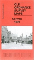
Corwen 1899
Corwen in 1899 in a fascinating series of reproductions of old Ordnance Survey plans in the Alan Godfrey Editions, ideal for anyone interested in the history of their neighbourhood or family. The map shows Corwen in 1899, with the railway line which closed in 1962 as a prominent feature;. Corwen boasted six hotels, four of which are still open today. Three quarriess are to the south of the town, one straight underneath the Corwen Union Workhouse which served six parishes in Merionethshire and seven in Denbighshire. The river Dee runs around the town travelling from one end of the map to the other above the railway line. The map also features an historical introduction by Derrick Pratt.About the Alan Godfrey Editions of the 25” OS Series:Selected towns in Great Britain and Ireland are
covered by maps showing the extent of urban development in the last decades of the 19th and early 20th century. The plans have been taken from the Ordnance Survey mapping and reprinted at about 15 inches to one mile (1:4, 340). On the reverse most maps have historical notes and many also include extracts from contemporary directories. Most maps cover about one mile (1.6kms) north/south, one and a half miles (2.4kms) across; adjoining sheets can be combined to provide wider coverage.FOR MORE INFORMATION AND A COMPLETE LIST OF ALL AVAILABLE TITLES PLEASE CLICK ON THE SERIES LINK.
covered by maps showing the extent of urban development in the last decades of the 19th and early 20th century. The plans have been taken from the Ordnance Survey mapping and reprinted at about 15 inches to one mile (1:4, 340). On the reverse most maps have historical notes and many also include extracts from contemporary directories. Most maps cover about one mile (1.6kms) north/south, one and a half miles (2.4kms) across; adjoining sheets can be combined to provide wider coverage.FOR MORE INFORMATION AND A COMPLETE LIST OF ALL AVAILABLE TITLES PLEASE CLICK ON THE SERIES LINK.

Product Description
Reviews/Comments
Add New
Intelligent Comparison
Archived Product
Corby 1899 Stanfords
£2.95
Archived Product

Corby 1899 Stanfords
£3.50
Archived Product

Morden 1894 Stanfords
£3.50
Archived Product
Darwen 1909 Stanfords
£2.95
Vouchers
No voucher codes found.
Do you know a voucher code for this product or supplier? Add it to Insights for others to use.
Do you know a voucher code for this product or supplier? Add it to Insights for others to use.
 Denmark