
 United Kingdom
 France
 Germany
 Netherlands
 Sweden
 USA
USA
 Italy
Italy
 Spain
Spain
More From Contributor

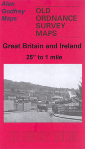
Consett 1896
Consett in 1896 in a fascinating series of reproductions of old Ordnance Survey plans in the Alan Godfrey Editions, ideal for anyone interested in the history of their neighbourhood or family. The map covers the steel town of Consett, which developed from a hamlet of just 146 people in 1831. The Derwent Iron Company was formed in 1841 and this was succeeded in 1864 by the Consett Iron Company. By 1891 the population was 8, 760. The town is in the top right quadrant of the map; the massive iron works dominates the western half and is shown here with all its railway tracks, blast furnaces, coke ovens. To the west is Consett Hall and Consett Grove. South of the town are railways: the NER Annfield Plain Branch, Iveston Railway, Consett Iron Works Railway. Other features include
Templetown, Delves Brick Works, Latterday Saint Pit, Puddlers Row, Town Hall, Carrhouse Quarry, Christ Church, Buildings Farm, etc. On the reverse are extracts from two directories of Consett. About the Alan Godfrey Editions of the 25” OS Series:Selected towns in Great Britain and Ireland are covered by maps showing the extent of urban development in the last decades of the 19th and early 20th century. The plans have been taken from the Ordnance Survey mapping and reprinted at about 15 inches to one mile (1:4, 340). On the reverse most maps have historical notes and many also include extracts from contemporary directories. Most maps cover about one mile (1.6kms) north/south, one and a half miles (2.4kms) across; adjoining sheets can be combined to provide wider coverage.FOR MORE
INFORMATION AND A COMPLETE LIST OF ALL AVAILABLE TITLES PLEASE CLICK ON THE SERIES LINK.

Product Description
Reviews/Comments
Add New
Vouchers
No voucher codes found.
Do you know a voucher code for this product or supplier? Add it to Insights for others to use.
Do you know a voucher code for this product or supplier? Add it to Insights for others to use.
 Denmark