More From Contributor

£35.00
Clwyd: Denbighshire & Flintshire Pevsner Architectural Guide, in a series of publications begun with the express aim of providing up-to-date guides to the most significant buildings in every part of the country, suitable for both general reader & specialist. Each volume provides an introductory overview of the architecture of the area, followed by a descriptive gazetteer arranged alphabetically by place. Whilst cathedrals & their furnishings, great country houses & their parks form the grand set pieces, the books demonstrate the enjoyable diversity of architecture in the British Isles in accounts of rural churches & farmsteads, Victorian public buildings & industrial monuments. A continuing programme of publication keeps the series up-to-date with new information on older buildings & recent architecture while maintaining the tradition of Pevsner`s own succinct accounts. Each book has over 100 photographs, mostly specially commissioned, numerous maps & plans, a glossary & indexes. ...
Archived Product
£6.39
A detailed topographic map of Clwydian Range / Bryniau Clwyd from the Ordnance Survey Explorer series, covering Prestatyn, Mold & Ruthin / Prestatyn, Yr Wyddgrug a Rhuthun. Edition A2; Publication date April 2009 About this series: These highly detailed maps show all the administrative boundaries, settlements as small as isolated farms, the road network down to unfenced roads & country tracks, & field boundaries (hedges & drystone walls) which make navigation across the countryside much easier. Steep gradients on roads are indicated. Various landmarks, e.g. powerlines, archaeological sites, windmills, churches & lighthouses are shown & additional graphics indicate natural terrain features such as cliffs, scree, mud & vegetation variations. The contour interval is 5 metres in the lower parts of the country & 10 metres in the uplands, & spot heights are marked. Each map covers an area of 30 x 20km (i.e. approx. 19 x 12 miles), with some double-sided maps covering more, as indicated in the individual descriptions. The maps are fully GPS compatible, with the National Grid shown at 1km intervals & latitude & longitude indicated by margin ticks at 1'. The Explorer series has replaced the earlier, green-cover Pathfinder maps. The Explorer series is now complete & covers all of Engl&, Wales & Scotl&. Some sheets for popular areas like the National Parks are still branded as Outdoor Leisure (OL) maps, but are now included in this series as the cartography is the same as that in the Explorer Maps. The Explorer maps offer a substantial improvement on the Pathfinder series, with greater use of colour, larger area per map, & stronger emphasis on information for ramblers & tourists. This series is ideal for walking & other outdoor pursuits & each map shows a large amount of information for ramblers & tourists. Public rights of way are shown (except in Scotland), together with other routes with public access: National Trails & Recreational Paths, permitted paths & bridleways, & selected cycle routes. Open access land created under the Countryside & Rights of Way Act 2000 is marked. Tourist information

Includes::
caravan & camp sites, Park & Ride locations, recreation/leisure/sport centres, museums, historic buildings, English Heritage & National Trust sites, rural pubs, etc. The map legend is in English only, except for the tourist information content which is also in French & German.

...
Archived Product
£14.99
Clwydian Range, Prestatyn, Mold & Ruthin area on a detailed topographic & GPS compatible map No. 265, waterproof version, from the Ordnance Survey’s 1:25, 000 Explorer series. MOBILE DOWNLOADS: this title & all the other OS Explorer maps include a code for downloading after purchase the digital version onto your smartphone or tablet for viewing on the OS smartphone app.OS EXPLORER SERIES: to see the list of all the titles in the OS Explorer series, both paper & waterproof versions, please click on the series link. The Explorer series, Ordnance Survey’s most detailed maps recommended for anyone enjoying outdoor activities, provides topographic coverage of Great Britain at 1:25, 000 on GPS compatible maps with hiking trails, cycling routes & extensive tourist information. Each printed map is available either on paper or as a waterproof & tear-resistant OS Active Map, as indicated in its title. Britain’s National Parks & other areas of particular tourist interest are presented on often double-sided OL (Outdoor Leisure) maps, whilst most standard format Explorers cover an area of 30 x 20km (approx. 19 x 12 miles). All three versions (paper, waterproof & digital) are the same & provide plenty of recreational & tourist information, indicating the traditional public right of way paths (except in Scotland where different laws apply), including bridleways & byways. National Trails & other long-distance paths are marked, as well as permissive footpaths or bridleways & on-road or traffic-free cycle routes with, where appropriate, their National/ Regional Cycle Network numbers. Boundaries of access land are clearly marked. A wide range of symbols provides additional tourist information, highlighting camping & caravanning sites, information offices & visitors’ centres, parking & picnicking places, country pubs, sport & recreational facilities including cycle hire locations & mountain biking trails, historic buildings & museums, etc. Exceptionally clear presentation of the landscape is provided by contours at 5m or in the uplands at 10m intervals, with additional spot heights plus colouring and/or graphics for different types of woodlands, orchards, heath, marshl&, scree or boulders, & other topographic features. For GPS users the maps have British National Grid lines at 1km intervals, with latitude & longitude given by margin ticks at 1`. Clearly laid out map legend

Includes::
French & German translations for the tourist information symbols.

...
Archived Product
£8.99
Clwydian Range, Prestatyn, Mold & Ruthin area on a detailed topographic & GPS compatible map No. 265, paper version, from the Ordnance Survey’s 1:25, 000 Explorer series. MOBILE DOWNLOADS: this title & all the other OS Explorer maps include a code for downloading after purchase the digital version onto your smartphone or tablet for viewing on the OS smartphone app.OS EXPLORER SERIES: to see the list of all the titles in the OS Explorer series, both paper & waterproof versions, please click on the series link. The Explorer series, Ordnance Survey’s most detailed maps recommended for anyone enjoying outdoor activities, provides topographic coverage of Great Britain at 1:25, 000 on GPS compatible maps with hiking trails, cycling routes & extensive tourist information. Each printed map is available either on paper or as a waterproof & tear-resistant OS Active Map, as indicated in its title. Britain’s National Parks & other areas of particular tourist interest are presented on often double-sided OL (Outdoor Leisure) maps, whilst most standard format Explorers cover an area of 30 x 20km (approx. 19 x 12 miles). All three versions (paper, waterproof & digital) are the same & provide plenty of recreational & tourist information, indicating the traditional public right of way paths (except in Scotland where different laws apply), including bridleways & byways. National Trails & other long-distance paths are marked, as well as permissive footpaths or bridleways & on-road or traffic-free cycle routes with, where appropriate, their National/ Regional Cycle Network numbers. Boundaries of access land are clearly marked. A wide range of symbols provides additional tourist information, highlighting camping & caravanning sites, information offices & visitors’ centres, parking & picnicking places, country pubs, sport & recreational facilities including cycle hire locations & mountain biking trails, historic buildings & museums, etc. Exceptionally clear presentation of the landscape is provided by contours at 5m or in the uplands at 10m intervals, with additional spot heights plus colouring and/or graphics for different types of woodlands, orchards, heath, marshl&, scree or boulders, & other topographic features. For GPS users the maps have British National Grid lines at 1km intervals, with latitude & longitude given by margin ticks at 1`. Clearly laid out map legend

Includes::
French & German translations for the tourist information symbols.

...
Archived Product
£11.19
Laminated waterproof edition of a detailed topographic map of Clwydian Range / Bryniau Clwyd from the Ordnance Survey Explorer series, covering Prestatyn, Mold & Ruthin / Prestatyn, Yr Wyddgrug a Rhuthun. Edition A2; Publication date April 2009 About this series: These highly detailed maps show all the administrative boundaries, settlements as small as isolated farms, the road network down to unfenced roads & country tracks, & field boundaries (hedges & drystone walls) which make navigation across the countryside much easier. Steep gradients on roads are indicated. Various landmarks, e.g. powerlines, archaeological sites, windmills, churches & lighthouses are shown & additional graphics indicate natural terrain features such as cliffs, scree, mud & vegetation variations. The contour interval is 5 metres in the lower parts of the country & 10 metres in the uplands, & spot heights are marked. Each map covers an area of 30 x 20km (i.e. approx. 19 x 12 miles), with some double-sided maps covering more, as indicated in the individual descriptions. The maps are fully GPS compatible, with the National Grid shown at 1km intervals & latitude & longitude indicated by margin ticks at 1'. The Explorer series has replaced the earlier, green-cover Pathfinder maps. The Explorer series is now complete & covers all of Engl&, Wales & Scotl&. Some sheets for popular areas like the National Parks are still branded as Outdoor Leisure (OL) maps, but are now included in this series as the cartography is the same as that in the Explorer Maps. The Explorer maps offer a substantial improvement on the Pathfinder series, with greater use of colour, larger area per map, & stronger emphasis on information for ramblers & tourists. This series is ideal for walking & other outdoor pursuits & each map shows a large amount of information for ramblers & tourists. Public rights of way are shown (except in Scotland), together with other routes with public access: National Trails & Recreational Paths, permitted paths & bridleways, & selected cycle routes. Open access land created under the Countryside & Rights of Way Act 2000 is marked. Tourist information

Includes::
caravan & camp sites, Park & Ride locations, recreation/leisure/sport centres, museums, historic buildings, English Heritage & National Trust sites, rural pubs, etc. The map legend is in English only, except for the tourist information content which is also in French & German.

...
Archived Product
£2.50
Clydebank street map from Nicolson Maps; coverage

Includes::
Drumchapel & Old Kilpatrick. Nicolson Maps, Scotland’s

...
Archived Product
£3.50
Clydebank in 1896 in a fascinating series of reproductions of old Ordnance Survey plans in the Alan Godfrey Editions, ideal for anyone interested in the history of their neighbourhood or family. Coverage stretches from the Kilbowie Factory southward to the Old Canal & Hamilton Free Church. Features include Kilbowie Sewing Machine Factory, Clydebank Engineering & Shipbuilding Works, dock, Kilbowie Iron Works, Forth & Clyde Canal, NBR railway with Kilbowie station, Lanarkshire & Dumbartonshire Railway with station, Glasgow Yoker & Clydebank Railway with terminus, railways into dock, chemical works, etc. On the reverse are extracts from a trade directory. About the Alan Godfrey Editions of the 25” OS Series: Selected towns in Great Britain & Ireland are covered by maps showing the extent of urban development in the last decades of the 19th & early 20th century. The plans have been taken from the Ordnance Survey mapping & reprinted at about 15 inches to one mile (1:4, 340). On the reverse most maps have historical notes & many also include extracts from contemporary directories. Most maps cover about one mile (1.6kms) north/south, one & a half miles (2.4kms) across; adjoining sheets can be combined to provide wider coverage.FOR MORE INFORMATION & A COMPLETE LIST OF ALL AVAILABLE TITLES PLEASE CLICK ON THE SERIES LINK. ...
Archived Product
£6.99
Street atlas of County Antrim & County Londonderry at 1:15, 800 from Collins, with enlarged city centre mapping of Belfast. The street mapping has been sourced from Ordnance Survey data with bold road classification colouring on a plain white base; main mapping is at 1:50, 000 & 1:20, 000 for the Greater Belfast areas & for the towns of Antrim, Ballyclare, Ballymena, Ballymoney, Carrickfergus, Coleraine, Cookstown, Larne, Limavady, Londonderry, Magherafelt, Newtownabbey, Portrush & Portstewart. These scales show motorways, A & B roads, & minor roads, with names clearly displayed; railways lines & stops, bus stops, & tramway lines & stops are marked. Local facilities such as post offices, police & fire stations, schools, car parks & mare are displayed. The enlarged city centre map of Belfast shows streets in greater detail at Approx. 1:8, 000, with one ways streets prominently highlighted. All mapping is indexed by street name, with highlighted schools, industrial estates, hospitals, & sports centres
- towns & villages included.
...
Archived Product
£5.50
Photoluminescent Vinyl
- 150mm x 150mm. Stanfords is an official distributor of Maritime Progress safety signs. We are able to
...
Archived Product
£12.99
This book covers the twelve fundamental aspects of successful sailing, & will help you to succeed on the water whether your aim is club, national, international (or even Olympic) level. With detailed analysis, challenging exercises & useful top tips throughout, everything is covered: from targets, goal setting & a winning mental attitude to boat handling, strategy & tactics (plus lots more). Handy diagrams on almost every page help to clarify complex concepts & scenarios, & brilliant action photographs bring the text to life. Each chapter is closed with not-to-be missed advice from Olympic medallists
- making this a must-have book for all sailors who aspire to great success. Written by a gold medal winning coach & sailor, this book will have you climbing the leaderboard in no time. It is a re-written & more focused version of the author`s popular title Be Your Own Sailing Coach, & its publication marks the re-launch of the iconic Sail to Win series, loved by sailors for over 30 years.
...
Archived Product

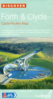
Clyde To Forth Cycle Routes

Forth and Clyde Cycle Routes at 1:100, 000 in a series of cycling maps from Sustrans, the charity behind developing UK’s National Cycle Network. The map is printed on light waterproof synthetic paper and presents the route on three panels linking Edinburgh, Glasgow and the Cowal Peninsula along the Union Canal and the Forth & Clyde Canal, with variants and day ride suggestions. Each title in the Sustrans series of cycling maps covers either a single route, presented in sections on separate strip maps, or a wider area with the main cycling route(s) prominently highlighted but other recommendations for cyclists also marked. The area covered each map is shown on our website on its individual “coverage” image.The route has markers indicating steep gradients, controlled access,
distances and possible danger points. Route profiles indicate riding surface and the density of traffic (main road, minor road and traffic-free) and, where appropriate, street plans show the course of the route across towns and cities. On maps covering a wider area around the main National Cycle Route suggestions of possible day ride excursions are also marked. A range of symbols highlight various facilities and places of interest, including tourist information centres, youth hostels, cafes and pubs, grocery shops, cycle shops and hire, historical and natural sites, etc.For access by rail, the rail network is shown with stations and, where appropriate, metro stations are also marked. Topography is shows by altitude colouring. Unless specifically indicated in the individual
description, the maps do not show British National Grid lines for GPS. Each title also contains contact addresses for various useful organizations, etc. Many titles are printed on light, waterproof and tear-resistant synthetic paper.
RIP - This product is no longer available on our network. It was last seen on 25.09.2019

This page now acts as a permanent archive for this product. Add more information using the comments box below to ensure it can still be found by future generations.

Use our search facility to see if it is available from an alternative contributor.
  • Availability: Out Of Stock
  • Supplier: Stanfords
  • SKU: 9781901389784
Availability: In Stock
£6.99

Product Description

Forth & Clyde Cycle Routes at 1:100, 000 in a series of cycling maps from Sustrans, the charity behind developing UK’s National Cycle Network. The map is printed on light waterproof synthetic paper & presents the route on three panels linking Edinburgh, Glasgow & the Cowal Peninsula along the Union Canal & the Forth & Clyde Canal, with variants & day ride suggestions. Each title in the Sustrans series of cycling maps covers either a single route, presented in sections on separate strip maps, or a wider area with the main cycling route (s) prominently highlighted but other recommendations for cyclists also marked. The area covered each map is shown on our website on its individual “coverage” image. The route has markers indicating steep gradients, controlled access, distances & possible danger points. Route profiles indicate riding surface & the density of traffic (main road, minor road & traffic-free) &, where appropriate, street plans show the course of the route across towns & cities. On maps covering a wider area around the main National Cycle Route suggestions of possible day ride excursions are also marked. A range of symbols highlight various facilities & places of interest, including tourist information centres, youth hostels, cafes & pubs, grocery shops, cycle shops & hire, historical & natural sites, etc. For access by rail, the rail network is shown with stations &, where appropriate, metro stations are also marked. Topography is shows by altitude colouring. Unless specifically indicated in the individual description, the maps do not show British National Grid lines for GPS. Each title also contains contact addresses for various useful organizations, etc. Many titles are printed on light, waterproof & tear-resistant synthetic paper.

Reviews/Comments

Add New

Intelligent Comparison

Oooops!
We couldn't find anything!
Perhaps this product's unique.... Or perhaps we are still looking for comparisons!
Click to bump this page and we'll hurry up.

Price History

Vouchers

No voucher codes found.
Do you know a voucher code for this product or supplier? Add it to Insights for others to use.

Facebook

Jargon Buster

GPS - Global Positioning System - Global position using satellites
Paper - A thin sheet mainly used for writing. Available in a variety of colours. Made mainly from wood pulp.
UK - United Kingdom - An island nation in Europe
Edinburgh - The capital city of Scotland
Waterproof - Resistant to water, usualy specified by depth in metres
Day - The time it takes a planet or other space objects to complete one rotation.
Natural - not manmade
Network - A link and communication between things. Often computers or people.
Road - a manmade lane or a path that is used to speed up travel.
Resistant - Something that can repel against something.
Altitude - Something that can be quite high in relation to sea or ground level.
Individual - A single separate item or person.

Supplier Information

Stanfords
Stanfords was established in 1853 and opened their iconic Covent Garden flagship store in 1901. They have become the top retailer of maps, travel books and accessories in the UK and arguably offer the largest selection of maps and travel books worldwide. Famous names such as Captain Robert Falcon Scott, Ranulph Fiennes and Michael Palin have purchased from Stanfords. They now have a shop in Bristol and both stores together with other venues operate a calendar of events including talks, book signings and exhibitions. As a specialist map retailer, the map selection is comprehensive and includes road maps, street maps and walking maps from worldwide destinations, as well as a selection of world atlases and wall maps. Books include travel guides and travel literature. Stanfords also stock globes, from miniatures made of blue marble to magnificent floor-standing globes. The website features a selection of interesting articles on travel topics.
Page Updated: 2023-11-12 20:15:36

Community Generated Product Tags

Oh No! The productWIKI community hasn't generated any tags for this product yet!
Menu