More From Contributor
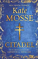
£3.50
Cirencester & Northleach in 1898 in a series of reproductions of Ordnance Survey’s famous ” Inch to the Mile” maps published in the Alan Godfrey Editions to provide a historical record of England & Wales in the second half of 19th & early 20th century. The map covers the area of east Gloucestershire around & to the north of Cirencester, stretching northward from Fairford to Dowdeswell, & from Elkstone eastward to Little Faringdon. Other locations on the map include: in GLOUCESTERSHIRE Aldsworth, Ampney Crucis, Ampney St Mary, Ampney St Peter, Aston Blank, Bagendon, Barnsley, Baunton, Bibury, Chedworth, Clapton, Cobenley, Colesborne, Coln Rogers, Coln St Aldwyn, Coln St Dennis, Compton Abdale, Cowley, Daglingworth, Duntisborne Abbotts, Duntisbotrne Rouse, Eastington, Eastleach Martin, Eastleach Turville, Farmington, Great Barrington, Great Rissington, Hampnett, Hatherop, Hazleton, Little Barrington, Little Rissington, North Cerney, Poulton, Preston, Quenington, Rendcomb, Sherborne, Shipton, Southrop, Stowell, Stratton, Taynton, Turkdean, Windrush, Winson, Winstone, Withington & Yanworth; plus in OXFORDSHIRE Broughton Poggs, Fifield, Holwell & Westwell. On the reverse is a detailed map of Northleach. About the Alan Godfrey Editions of the OS Inch to the Mile Maps: the maps provide an invaluable overview of a wider area, typically 18 x 12 miles (29 x 19 kms approx.), & offer historical mapping for small towns & villages not covered by the more detailed series for which the Godfrey Editions are better known. On the reverse all the maps have historical notes & most titles also include a more detailed, large scale map of a small town or a village in the area. To see other titles in this series please click on the series link. ...
Archived Product
£3.50
Cirencester East in 1920 in a fascinating series of reproductions of old Ordnance Survey plans in the Alan Godfrey Editions, ideal for anyone interested in the history of their neighbourhood or family. Cirencester is covered by two maps. This title shows the eastern half of the town, stretching from the east end of Market Place eastward to Kingshill Lane & beyond. Part of Preston village, including All Saints church, is in the south-easten corner. A major aspect of the map is the Watermoor area, where features include the Midland & South Western Junction Railway with station & engine house. Other features include Trinity church, Watermoor House, Poor Law Institution, Royal Nursery, Dyer Street, Victoria Road, Watermoor Road, Tower Street, The Avenue, Lewis Lane, The Beeches, Golden Farm, isolation hospital, Preston Forty. On the reverse are extracts from an 1894 directory, including commercial entries J to Z. About the Alan Godfrey Editions of the 25” OS Series Selected towns in Great Britain & Ireland are covered by maps showing the extent of urban development in the last decades of the 19th & early 20th century. The plans have been taken from the Ordnance Survey mapping & reprinted at about 15 inches to one mile (1:4, 340). On the reverse most maps have historical notes & many also include extracts from contemporary directories. Most maps cover about one mile (1.6kms) north/south, one & a half miles (2.4kms) across; adjoining sheets can be combined to provide wider coverage.FOR MORE INFORMATION & A COMPLETE LIST OF ALL AVAILABLE TITLES PLEASE CLICK ON THE SERIES LINK. ...
Archived Product
£3.50
Cirencester West in 1920 in a fascinating series of reproductions of old Ordnance Survey plans in the Alan Godfrey Editions, ideal for anyone interested in the history of their neighbourhood or family. Cirencester is covered by two maps. This title shows the western half of the town, with coverage running from the Market Place & St John`s church westward to Cirencester Park & College Farm, & from Coxwell Street & The Abbey southward to Cranhams Farm & Chesterton. Features include Castle Street, Park Street, GWR terminus, Bull Ring (Roman Amphitheatre), cattle market, Ashcroft Road, Cricklade Street, Cirencester Park, cemetery, Cotswold bacon factory, Royal Agricultural College. On the reverse is a commercial directory from 1894, entries A to I & a 1906 timetable for the GWR`s Cirencester Branch. About the Alan Godfrey Editions of the 25” OS Series Selected towns in Great Britain & Ireland are covered by maps showing the extent of urban development in the last decades of the 19th & early 20th century. The plans have been taken from the Ordnance Survey mapping & reprinted at about 15 inches to one mile (1:4, 340). On the reverse most maps have historical notes & many also include extracts from contemporary directories. Most maps cover about one mile (1.6kms) north/south, one & a half miles (2.4kms) across; adjoining sheets can be combined to provide wider coverage.FOR MORE INFORMATION & A COMPLETE LIST OF ALL AVAILABLE TITLES PLEASE CLICK ON THE SERIES LINK. ...
Archived Product
£15.99
Initially published to celebrate the 900th anniversary of the establishment of the Cistercian order in 1098, this is a guide to all the Cistercian abbeys in Britain. The 86 sites include the beautiful ruins of Tintern, Fountains, Rievaulx & Melrose, as well as the home of Sir Francis Drake & the burial place of the last Welsh Prince of Wales. Each gazetteer entry describes the history & architecture of the site & the people connected with it, & there are chapters on the overall history & architecture of the Cistercian order. There are also plans of all the abbeys, a detailed bibliography, & practical details such as grid references & information on access to each site. ...
Archived Product
£6.95
Topographic coverage of mainland Spain at 1:50, 000 in the MTN50 (Mapa Topográfico Nacional) series from the Centro Nacional de Información Geografica, the country’s civilian survey organization. The maps have contours at 20m intervals, enhanced by relief shading, plus colouring and/or graphics to show different types of terrain, vegetation or land use. Boundaries of national parks & other protected areas are marked. In addition to all the usual information featured on topographic mapping at this scale, detailed presentation of the road & rail networks, rural tracks & paths, etc, the maps also show campsites & mountain refuges. On more recent editions some GRs, the official long-distance hiking routes, are also marked (although not as clearly as on hiking maps from other publishers). Each map covers 29.5x 18.5 km (with adjustments in the border or coastal areas). The maps have a 1-km UTM grid, plus margin ticks for latitude & longitude at 1` intervals. Map legend is in Spanish only.HOW TO CHOOSE THE RIGHT 50K MAP: all the titles in CNIG’s 200K Provincial Road Maps series at 1:200, 000 are overprinted with the grid for the 1:50, 000 maps & can be used to see the area covered by each 50K title. TO SEE THE LIST OF TITLES IN THIS SERIES PLEASE CLICK ON THE SERIES LINK.PLEASE NOTE
- MAP TITLES: the grids shown on our website serve both the civilian & the military 1:50, 000 topographic series. Although the areas covered by maps in both series are identical (apart from some border or coastal sheets), occasionally map titles differ – only one title is shown on the grid, usually the military one. In Galicia, the Basque country & in the Catalan speaking areas the tendency now is to use local place names rather than the often better known Castilian ones. Where possible, both versions are included in our titles. Map titles listed on our website are based on information received by us at the time of publication, but sometimes maps arrive showing a completely different title! As long as the map number is as ordered, the correct map has been supplied.
...
Archived Product
£7.99
Carcassonne 1942. A spirited & courageous young woman, Sandrine, finds herself drawn into the world of the Resistance in Carcassonne under German Occupation. Her network
- codenamed ' Citadel'
- is made up of ordinary women who risk everything to fight the sinister battles raging in the shadows around them. As the war reaches its violent & bloody conclusion, Sandrine's fate is tied up with that of three very different men. But who is the real enemy? Who is the real threat? & who is the true guardian of the ancient secrets that for generations have drawn people to the foothills of the Pyrenean mountains?

...
Archived Product
£9.99
Cities is a fascinating exploration of the nature of the city & city life, of its structures, development & inhabitants. From the ruins of the earliest cities to the present, Reader explores how cities coalesce, develop & thrive, how they can decline & die, how they remake themselves. He investigates their parasitic relationship with the countryside around them, the webs of trade & immigration they rely upon to survive, how they feed & water themselves & dispose of their wastes. It is a sweeping exploration of what the city is & has been, fit to stand alongside Lewis Mumford`s 1962 classic The City in History. ...
Archived Product
£10.99
The 21st century will be the age of the city. Already over 50% of the world population live in urban centres & over the coming decades this percentage will increase. Blending anecdote, fact & first hand encounters
- from exploring the slums of Mumbai, to visiting roof-top farms in Brooklyn & attending secret dinner parties in Paris, to riding the bus in Latin America
- Leo Hollis reveals that we have misunderstood how cities work for too long. Upending long-held assumptions & challenging accepted wisdom, he explores: why cities can never be rational, organised places; how we can walk in a crowd without bumping into people, & if we can design places that make people want to kiss; whether we have the right solution to the problem of the slums; how ants, slime mould & traffic jams can make us rethink congestion. & above all, the unexpected reasons why living in the city can make us fitter, richer, smarter, greener, more creative
- &, perhaps, even happier. Cities Are Good for You introduces dreamers, planners, revolutionaries, writers, scientists, architects, slum-dwellers & emperors. It is shaped by the idea that cities are the greatest social experiment in human history, built for people, & by the people.


...
Archived Product
£12.99
A series of vintage street maps of the world’s major cites in a jigsaw format: Piatnik introduces a series of 1000 pieces jigsaw puzzles reproducing old maps of the world’s most beautiful cites. The puzzles are presented in elegant carton boxes, decorated with overviews of the maps. The perfect gift for tourists & puzzle enthusiasts. ...
Archived Product
£25.00
From Alexandria to York, this unique illustrated guide allows us to see the great centres of classical civilization afresh. The key feature of ” Cities of the Classical World” is 120 specially drawn maps tracing each city`s thoroughfares & defences, monuments & places of worship. Every map is to the same scale, allowing readers for the first time to appreciate visually the relative sizes of Babylon & Paris, London & Constantinople. There is also a clear, incisive commentary on each city`s development, strategic importance, rulers & ordinary inhabitants. This compelling & elegant atlas opens a new window on to the ancient world, & will transform the way we see it. ...
Archived Product

Citadel

Set in Carcassonne during WWII, Citadel by Kate Mosse explores the history, legends and secrets of Languedoc. This is a powerful story about courage, loyalty and betrayal packed with action and mystery. The novel follows the young heroine Sandrine, her secret ‘Citadel’ network, and the characters involved in the struggle under the German occupation. The background is provided by a rich history of the region and an ancient legend about a heretical text that becomes the reason behind torture, murder and treason. The vivid action scenes and the poignant detailed observations of daily lives bring the sacrifices and horror of the struggle to life. This book can be read as the concluding part of a trilogy set in the south west of France, and readers of the previous instalments will
find some recurrent themes and characters. Nevertheless, the novel stands perfectly well on its own. Citadel is a remarkable story of courage and people fighting for their beliefs, entwined with romance and mysticism. The unremitting tension and high emotions, marking the story that unravels in a powerful historical background, make this book a page turner.
RIP - This product is no longer available on our network. It was last seen on 25.09.2019

This page now acts as a permanent archive for this product. Add more information using the comments box below to ensure it can still be found by future generations.

Use our search facility to see if it is available from an alternative contributor.
  • Availability: Out Of Stock
  • Supplier: Stanfords
  • SKU: 9780752876474
Availability: In Stock
£20.00

Product Description

Set in Carcassonne during WWII, Citadel by Kate Mosse explores the history, legends & secrets of Languedoc. This is a powerful story about courage, loyalty & betrayal packed with action & mystery. The novel follows the young heroine Sandrine, her secret ‘ Citadel’ network, & the characters involved in the struggle under the German occupation. The background is provided by a rich history of the region & an ancient legend about a heretical text that becomes the reason behind torture, murder & treason. The vivid action scenes & the poignant detailed observations of daily lives bring the sacrifices & horror of the struggle to life. This book can be read as the concluding part of a trilogy set in the south west of France, & readers of the previous instalments will find some recurrent themes & characters. Nevertheless, the novel stands perfectly well on its own. Citadel is a remarkable story of courage & people fighting for their beliefs, entwined with romance & mysticism. The unremitting tension & high emotions, marking the story that unravels in a powerful historical background, make this book a page turner.

Reviews/Comments

Add New

Intelligent Comparison

Oooops!
We couldn't find anything!
Perhaps this product's unique.... Or perhaps we are still looking for comparisons!
Click to bump this page and we'll hurry up.

Price History

Vouchers

No voucher codes found.
Do you know a voucher code for this product or supplier? Add it to Insights for others to use.

Facebook

Jargon Buster

Tension - A force that is stretching an object
Tension - Also known as stress, a situation where a human can not cope with emotional or physical threats
France - A state situated in Western Europe with several overseas territories.
History - Anything that happens in the past. An acedemic subject.
Set - a group of items usually related to one another. Some objects cannot function without the complete set of items.
Network - A link and communication between things. Often computers or people.

Supplier Information

Stanfords
Stanfords was established in 1853 and opened their iconic Covent Garden flagship store in 1901. They have become the top retailer of maps, travel books and accessories in the UK and arguably offer the largest selection of maps and travel books worldwide. Famous names such as Captain Robert Falcon Scott, Ranulph Fiennes and Michael Palin have purchased from Stanfords. They now have a shop in Bristol and both stores together with other venues operate a calendar of events including talks, book signings and exhibitions. As a specialist map retailer, the map selection is comprehensive and includes road maps, street maps and walking maps from worldwide destinations, as well as a selection of world atlases and wall maps. Books include travel guides and travel literature. Stanfords also stock globes, from miniatures made of blue marble to magnificent floor-standing globes. The website features a selection of interesting articles on travel topics.
Page Updated: 2023-11-12 20:15:36

Community Generated Product Tags

Oh No! The productWIKI community hasn't generated any tags for this product yet!
Menu