
 United Kingdom
 France
 Germany
 Netherlands
 Sweden
 USA
USA
 Italy
Italy
 Spain
Spain
More From Contributor


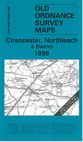
Cirencester And Northleach 1898
Cirencester and Northleach in 1898 in a series of reproductions of Ordnance Survey’s famous ”Inch to the Mile” maps published in the Alan Godfrey Editions to provide a historical record of England and Wales in the second half of 19th and early 20th century.The map covers the area of east Gloucestershire around and to the north of Cirencester, stretching northward from Fairford to Dowdeswell, and from Elkstone eastward to Little Faringdon. Other locations on the map include: in GLOUCESTERSHIRE Aldsworth, Ampney Crucis, Ampney St Mary, Ampney St Peter, Aston Blank, Bagendon, Barnsley, Baunton, Bibury, Chedworth, Clapton, Cobenley, Colesborne, Coln Rogers, Coln St Aldwyn, Coln St Dennis, Compton Abdale, Cowley, Daglingworth, Duntisborne Abbotts, Duntisbotrne Rouse,
Eastington, Eastleach Martin, Eastleach Turville, Farmington, Great Barrington, Great Rissington, Hampnett, Hatherop, Hazleton, Little Barrington, Little Rissington, North Cerney, Poulton, Preston, Quenington, Rendcomb, Sherborne, Shipton, Southrop, Stowell, Stratton, Taynton, Turkdean, Windrush, Winson, Winstone, Withington and Yanworth; plus in OXFORDSHIRE Broughton Poggs, Fifield, Holwell and Westwell. On the reverse is a detailed map of Northleach.About the Alan Godfrey Editions of the OS Inch to the Mile Maps: the maps provide an invaluable overview of a wider area, typically 18 x 12 miles (29 x 19 kms approx.), and offer historical mapping for small towns and villages not covered by the more detailed series for which the Godfrey Editions are better
known. On the reverse all the maps have historical notes and most titles also include a more detailed, large scale map of a small town or a village in the area.To see other titles in this series please click on the series link.

Product Description
Reviews/Comments
Add New
Vouchers
No voucher codes found.
Do you know a voucher code for this product or supplier? Add it to Insights for others to use.
Do you know a voucher code for this product or supplier? Add it to Insights for others to use.
 Denmark