
 United Kingdom
 France
 Germany
 Netherlands
 Sweden
 USA
USA
 Italy
Italy
 Spain
Spain
More From Contributor


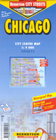
Chicago
Chicago street plan on a light, waterproof and tear-resistant map from Berndtson, highlighting the windy city’s top 15 sights, with smaller maps of the Lincoln Park; Hyde Park; and the environs of Chicago.On one side is a plan at 1:9, 000 of downtown Chicago, highlighting numerous places of interest. 15 top sites are prominently marked on the map itself, with a small box giving brief information one each site. Shopping centres and markets are clearly indicated, as well as hotels, cinemas, theatres and museums. L train stations are marked, with a diagram of the Chicago Transit Authority network included on the map’s reverse. An enlargement presents Lincoln Park at 1:16, 000.On the reverse is a map at 1:250, 000 of Chicago and it’s surrounding area, showing the area’s road
networks and major points of interest. There is also a map showing the Hyde Park area of the city at 1:20, 000. Finally, a small enlargement of O-Hare Airport is included, showing parking, gates, and which airlines fly from where. All maps are indexed, including separate lists of places of interest, markets and shopping centres, parks, quarters etc. Also included is, graphs showing the city’s climate month by month, plus general tourist information.The map is printed on light, waterproof and tear-resistant plastic paper. Map legend includes English. All descriptions and general information are in English only.
networks and major points of interest. There is also a map showing the Hyde Park area of the city at 1:20, 000. Finally, a small enlargement of O-Hare Airport is included, showing parking, gates, and which airlines fly from where. All maps are indexed, including separate lists of places of interest, markets and shopping centres, parks, quarters etc. Also included is, graphs showing the city’s climate month by month, plus general tourist information.The map is printed on light, waterproof and tear-resistant plastic paper. Map legend includes English. All descriptions and general information are in English only.

Product Description
Reviews/Comments
Add New
Vouchers
No voucher codes found.
Do you know a voucher code for this product or supplier? Add it to Insights for others to use.
Do you know a voucher code for this product or supplier? Add it to Insights for others to use.
 Denmark