More From Contributor
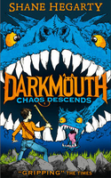
£19.95
A comprehensive waypoint pilot for both sides of the English Channel, from the Isles of Scilly to Ramsgate, & Calais to the Chenal du Four.

Includes::
the Channel Islands & over 50 cross-channel routes. This Waypoint Guide has been compiled for the convenience of anyone who uses electronic systems for navigating the popular cruising areas of the English Channel, under sail or power. The waypoints presented in this guide have certainly been set with safety in mind, but they have also been chosen to be practical in all kinds of passage-making circumstances, whether yachts are pottering fairly close inshore within a local area, cruising between neighbouring coastal areas, or arriving on a particular stretch of coast after a longish offshore passage. Near the front of the guide is a set of charts, waypoints & routes for crossing different sections of the English Channel. In full colour with charts devised by Jane Cumberlidge

...
Archived Product
£12.99
Map No. 1346, Chanrion, in the topographic survey of Switzerland at 1:25, 000 from Bundesamt für Landestopographie (swisstopo), covering the whole country on 247 small format sheets, with special larger maps published for popular regions including some titles now available in hiking versions. Highly regarded for their superb use of graphic relief & hill shading, the maps give an almost 3-D picture of Switzerland`s mountainous terrain. Contours are at 10 m intervals, with 20m intervals in the mountainous areas. All the maps have a 1-km grid for Swiss national coordinates (datum CH 1903). * Small format sheets (Nos. 1011
- 1374)* Map legend in the language of the area covered by the map. Additional margin ticks show latitude & longitude in steps of 2`. The area covered by each map is 17 x 12 km (11 x 7 miles approx). * Special larger sheets (Nos. from 2501 onwards) – STANDARD editions:* No map legend is included but a separate leaflet can be provided instead. The area covered by each map is 25 x 17 km (15 x 11 miles approx).* Special larger sheets (Nos. from 2501 onwards) – HIKING editions:* An overprint highlights hiking, mountain & alpine paths, including regional & national long-distance trails. The maps also show bus routes with bus stops, plus inns in remote locations. The area covered by each map is 25 x 17 km (15 x 11 miles approx).
...
Archived Product
£6.95
Topographic coverage of mainland Spain at 1:50, 000 in the MTN50 (Mapa Topográfico Nacional) series from the Centro Nacional de Información Geografica, the country’s civilian survey organization. The maps have contours at 20m intervals, enhanced by relief shading, plus colouring and/or graphics to show different types of terrain, vegetation or land use. Boundaries of national parks & other protected areas are marked. In addition to all the usual information featured on topographic mapping at this scale, detailed presentation of the road & rail networks, rural tracks & paths, etc, the maps also show campsites & mountain refuges. On more recent editions some GRs, the official long-distance hiking routes, are also marked (although not as clearly as on hiking maps from other publishers). Each map covers 29.5x 18.5 km (with adjustments in the border or coastal areas). The maps have a 1-km UTM grid, plus margin ticks for latitude & longitude at 1` intervals. Map legend is in Spanish only.HOW TO CHOOSE THE RIGHT 50K MAP: all the titles in CNIG’s 200K Provincial Road Maps series at 1:200, 000 are overprinted with the grid for the 1:50, 000 maps & can be used to see the area covered by each 50K title. TO SEE THE LIST OF TITLES IN THIS SERIES PLEASE CLICK ON THE SERIES LINK.PLEASE NOTE
- MAP TITLES: the grids shown on our website serve both the civilian & the military 1:50, 000 topographic series. Although the areas covered by maps in both series are identical (apart from some border or coastal sheets), occasionally map titles differ – only one title is shown on the grid, usually the military one. In Galicia, the Basque country & in the Catalan speaking areas the tendency now is to use local place names rather than the often better known Castilian ones. Where possible, both versions are included in our titles. Map titles listed on our website are based on information received by us at the time of publication, but sometimes maps arrive showing a completely different title! As long as the map number is as ordered, the correct map has been supplied.
...
Archived Product
£7.99
This lyrical evocation of growing up on the banks of the Seine was originally published in 1964. In this minutely observed landscape, where even the wind is a character in its own right, we meet blind Battouflet, the singing hermit of the hillside, solemn Clotilde, the author`s first girlfriend who lives in a chateau in the heart of the forest, & a desiccated & disturbing spinster, Mlle. Firman. Fedden writes with preternatural clarity, taking the reader with him into a long-forgotten yet echoingly familiar world. When Fedden finds himself expelled from this realm by his emerging sexuality, he leaves us reeling with nostalgia for that timeless sense of the present that is the magic of childhood. ...
Archived Product
£11.50
Topographic survey of France at 1:25, 000 in IGN`s excellent TOP25 / Série Bleue series. All the maps are GPS compatible, with a 1km UTM grid plus latitude & longitude lines at 5’ intervals. Contours are at 5m intervals except for mountainous areas where the maps have contours at 10m intervals, vividly enhanced by hill shading & graphics for rocky terrain. Colouring with graphics indicates different types of vegetation or land use (deciduous or coniferous forests, moors, orchards, vineyards, etc). PLEASE NOTE: coverage of France at this scale is currently being revised – the format & the presentation of each title are indicated by the letters at the end of its Sheet Reference number (e.g. 0416ET, 3531ETR, 1923SB, etc.)MAPS WITH FULL TOURIST OVERPRINT & AN ENGLISH MAP LEGEND: all TOP25 maps & the SB editions of Série Bleue have an overprint highlighting waymarked walking trails including long-distance GR routes &, where appropriate, ski routes. Symbols indicate campsites, gîtes d’etape, refuges, equestrian centres & other recreational facilities or sites, tourist information centres, cultural heritage, etc. Towns & locations of particular interest are highlighted.- ET or OT = single-sided TOP25 map covering approx. 29x 21 km / 18x 13 miles.- ETR or OTR = waterproof & tear resistant TOP25 map covering the same area as the corresponding ET or OT number, but double-sided, printed on a smaller size sheet with a good overlap between the sides.- SB = Série Bleue map with full tourist overprint; these maps, first introduced in summer 2014, each cover approx. 29x 24km / 18x 15 miles.SÉRIE BLEUE maps with numbers ending in E (Est) or O (Ouest): most editions now indicate the GR routes, but do not show any other tourist information. Map legend is in French only. Each map covers approx. 14x 20km / 9x 12 miles. ...
Archived Product
£6.99
The third book in the monstrously funny & action-packed Darkmouth series. It`s going to be legendary. The adventures of the most unfortunate Legend Hunter ever to don fighting armour & pick up a desiccator continue... Finn`s been through so much, he`ll now be allowed do what he wants with the rest of his life, right? Wrong. Whether he likes it or not, he`s going to be made a proper Legend Hunter. But then suddenly people start disappearing, Legends are appearing where they shouldn`t, Broonie`s complaining, Emmie`s got a secret
- & an attack so big is coming that Finn has the weight of the world on his shoulders. The weight of two worlds, actually...
...
Archived Product
£8.99
We have a choice: Breakdown or Breakthrough. In THE CHAOS POINT revered author & systems theorist Ervin Laszlo tells us that we are at a critical juncture in history, a `decision-window` where we face both the danger of global collapse & the opportunity of worldwide renewal. According to Laszlo we have six to seven years to head off unsustainable trends that would lead to a `tipping point` beyond which there is no turning back. After this tipping point we either evolve to a safer, more sustainable world, or the social, economic & ecological systems that frame our life break down. This is the Chaos Point, but this need not be the end of the world, only the end of a phase of the world beyond which a new world could dawn. In today`s decision-window we have a unique chance of creating that new world & this pioneering book tells us what healing & renewal means, & how each of us can help in achieving it. ...
Archived Product
£8.95
Chaouia at 1:500, 000 in a regional series published in Morocco by Carima (Societe de Cartographie et d' Imprimerie du Maroc). The cartography & print quality are rather basic, but these maps show more place names than are found on general maps of the whole country. There is no hill-shading or relief contouring, but there are spot heights for significant peaks & many water features shown: rivers, lakes, & wells. Road detail

Includes::
minor routes & tracks, on many roads intermediate driving distances are stated, plus location of petrol stations & car mechanics. Railways & airports are indicated & symbols denote features such as kasbas, ruins, forts, mines, viewpoints, etc. Map legend is in French & Arabic. PLEASE NOTE: Some previously published titles are currently not available from Carima, with no date when they are likely to be return into stock. On the back cover of each map a diagram shows a series of 16 sheets covering the whole of Morocco, including the Western Sahara. However, only six maps were ever published & the remaining maps will not be done.

...
Archived Product
£12.99
Topographic survey of France at 1:25, 000 in IGN`s excellent TOP25 / Série Bleue series. All the maps are GPS compatible, with a 1km UTM grid plus latitude & longitude lines at 5’ intervals. Contours are at 5m intervals except for mountainous areas where the maps have contours at 10m intervals, vividly enhanced by hill shading & graphics for rocky terrain. Colouring with graphics indicates different types of vegetation or land use (deciduous or coniferous forests, moors, orchards, vineyards, etc). PLEASE NOTE: coverage of France at this scale is currently being revised – the format & the presentation of each title are indicated by the letters at the end of its Sheet Reference number (e.g. 0416ET, 3531ETR, 1923SB, etc.)MAPS WITH FULL TOURIST OVERPRINT & AN ENGLISH MAP LEGEND: all TOP25 maps & the SB editions of Série Bleue have an overprint highlighting waymarked walking trails including long-distance GR routes &, where appropriate, ski routes. Symbols indicate campsites, gîtes d’etape, refuges, equestrian centres & other recreational facilities or sites, tourist information centres, cultural heritage, etc. Towns & locations of particular interest are highlighted.- ET or OT = single-sided TOP25 map covering approx. 29x 21 km / 18x 13 miles.- ETR or OTR = waterproof & tear resistant TOP25 map covering the same area as the corresponding ET or OT number, but double-sided, printed on a smaller size sheet with a good overlap between the sides.- SB = Série Bleue map with full tourist overprint; these maps, first introduced in summer 2014, each cover approx. 29x 24km / 18x 15 miles.SÉRIE BLEUE maps with numbers ending in E (Est) or O (Ouest): most editions now indicate the GR routes, but do not show any other tourist information. Map legend is in French only. Each map covers approx. 14x 20km / 9x 12 miles. ...
Archived Product
£3.50
Chapel Allerton & Gledhow in 1906 in a fascinating series of reproductions of old Ordnance Survey plans in the Alan Godfrey Editions, ideal for anyone interested in the history of their neighbourhood or family. The map covers Chapel Allerton on the north side of Leeds. Most of the village is shown, including Old Church, Allerton Hall, Allerton House, Allerton Hill, St Matthew`s church, Allerton Park, Hawkhills & Woodland Lane. The Harrogate Road (with tramway) runs through the village, & the map extends north along it to Moor Allerton Bottoms, Whinbrook & Broomhill Farm. East of the village is Gledhow Park & coverage extends east to cover Gledhow, including Gledhow Hall, Oakley House & the group of streets between Lidgett Lane & Jackson Avenue. To the north are Lidgett Farm, Allerton Grange & Moor Allerton Hall. A good selection of street directory entries is included on the reverse, including Gledhow Wood Avenue/ Grove, Harrogate Road, Hawthorn Vale/ View, Jackson Avenue, Lidgett Lane & Town Street. About the Alan Godfrey Editions of the 25” OS Series: Selected towns in Great Britain & Ireland are covered by maps showing the extent of urban development in the last decades of the 19th & early 20th century. The plans have been taken from the Ordnance Survey mapping & reprinted at about 15 inches to one mile (1:4, 340). On the reverse most maps have historical notes & many also include extracts from contemporary directories. Most maps cover about one mile (1.6kms) north/south, one & a half miles (2.4kms) across; adjoining sheets can be combined to provide wider coverage.FOR MORE INFORMATION & A COMPLETE LIST OF ALL AVAILABLE TITLES PLEASE CLICK ON THE SERIES LINK. ...
Archived Product

Chaos Descends

The third book in the monstrously funny and action-packed Darkmouth series. It`s going to be legendary. The adventures of the most unfortunate Legend Hunter ever to don fighting armour and pick up a desiccator continue...Finn`s been through so much, he`ll now be allowed do what he wants with the rest of his life, right? Wrong. Whether he likes it or not, he`s going to be made a proper Legend Hunter. But then suddenly people start disappearing, Legends are appearing where they shouldn`t, Broonie`s complaining, Emmie`s got a secret - and an attack so big is coming that Finn has the weight of the world on his shoulders. The weight of two worlds, actually...
RIP - This product is no longer available on our network. It was last seen on 25.09.2019

This page now acts as a permanent archive for this product. Add more information using the comments box below to ensure it can still be found by future generations.

Use our search facility to see if it is available from an alternative contributor.
  • External links may include paid for promotion
  • Availability: Out Of Stock
  • Supplier: Stanfords
  • SKU: 9780007545681
Availability: In Stock
£12.99

Product Description

The third book in the monstrously funny & action-packed Darkmouth series. It`s going to be legendary. The adventures of the most unfortunate Legend Hunter ever to don fighting armour & pick up a desiccator continue... Finn`s been through so much, he`ll now be allowed do what he wants with the rest of his life, right? Wrong. Whether he likes it or not, he`s going to be made a proper Legend Hunter. But then suddenly people start disappearing, Legends are appearing where they shouldn`t, Broonie`s complaining, Emmie`s got a secret
- & an attack so big is coming that Finn has the weight of the world on his shoulders. The weight of two worlds, actually...

Reviews/Comments

Add New

Intelligent Comparison

Oooops!
We couldn't find anything!
Perhaps this product's unique.... Or perhaps we are still looking for comparisons!
Click to bump this page and we'll hurry up.

Price History

Vouchers

No voucher codes found.
Do you know a voucher code for this product or supplier? Add it to Insights for others to use.

Facebook

Jargon Buster

World - A physical grouping, commonly used to describe earth and everything associated with ti
weight - A measure of the force applied on an object by gravity. Measured metric in grams and kilos or imperial in lbs and oz
Weight - a measurement of how heavy an object appears due to the pull of gravity. For example the weight of an object on planet earth will be different to the weight of the object on the moon

Supplier Information

Stanfords
Stanfords was established in 1853 and opened their iconic Covent Garden flagship store in 1901. They have become the top retailer of maps, travel books and accessories in the UK and arguably offer the largest selection of maps and travel books worldwide. Famous names such as Captain Robert Falcon Scott, Ranulph Fiennes and Michael Palin have purchased from Stanfords. They now have a shop in Bristol and both stores together with other venues operate a calendar of events including talks, book signings and exhibitions. As a specialist map retailer, the map selection is comprehensive and includes road maps, street maps and walking maps from worldwide destinations, as well as a selection of world atlases and wall maps. Books include travel guides and travel literature. Stanfords also stock globes, from miniatures made of blue marble to magnificent floor-standing globes. The website features a selection of interesting articles on travel topics.
Page Updated: 2023-11-12 20:15:36

Community Generated Product Tags

Oh No! The productWIKI community hasn't generated any tags for this product yet!
Menu