
 United Kingdom
 France
 Germany
 Netherlands
 Sweden
 USA
USA
 Italy
Italy
 Spain
Spain
More From Contributor

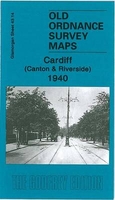
Cardiff Canton And Riverside 1940
Cardiff Canton and Riverside in 1940 in a fascinating series of reproductions of old Ordnance Survey plans in the Alan Godfrey Editions, ideal for anyone interested in the history of their neighbourhood or family. The map covers the Canton area and part of the Riverside area of Cardiff. Coverage stretches from Cathedral Road and Neville Street westward to Victoria Park, and southward to Virgil Street. Features include Canton railway depot with engine shed, carriage sheds, turntable, sidings etc; Ninian Park football ground, St John`s church, tramways, City Isolation Hospital, Canton Brick Works, Ely River, St Luke`s church, malthouse, slaughter-house, cinemas, City Lodge, Leckwith Road, etc. On the reverse are extracts from a 1906 street directory, including Alexander
Road, Atlas Road, Cowbridge Road, Beda Road, Craddock Street, Leckwith Road. Crwys Road, Diana Street, Donald Street, St Andrew`s Crescent and Wyeverne Street.About the Alan Godfrey Editions of the 25” OS Series:Selected towns in Great Britain and Ireland are covered by maps showing the extent of urban development in the last decades of the 19th and early 20th century. The plans have been taken from the Ordnance Survey mapping and reprinted at about 15 inches to one mile (1:4, 340). On the reverse most maps have historical notes and many also include extracts from contemporary directories. Most maps cover about one mile (1.6kms) north/south, one and a half miles (2.4kms) across; adjoining sheets can be combined to provide wider coverage.FOR MORE INFORMATION AND A COMPLETE LIST
OF ALL AVAILABLE TITLES PLEASE CLICK ON THE SERIES LINK.

Product Description
Reviews/Comments
Add New
Vouchers
No voucher codes found.
Do you know a voucher code for this product or supplier? Add it to Insights for others to use.
Do you know a voucher code for this product or supplier? Add it to Insights for others to use.
 Denmark