More From Contributor
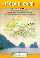
£9.99
Map No. 267, Capitol Reef National Park in Utah at 1:75, 000 in an extensive series of GPS compatible, contoured hiking maps of USA’s national & state parks or forests & other popular recreational areas. Cartography based on the national topographic survey, with additional tourist information. The maps, with most titles now printed on light, waterproof & tear-resistant plastic paper, highlight walking trails along with campsites & other accommodation, picnic sites, areas for various recreational pursuits such as horse riding or skiing, drinking water sources, & many other facilities of interest to the outdoor enthusiast. Cartography is based on information from the USGS (United States Geological Survey
- the country’s national survey organization), revised by the National Geographic Maps in cooperation with the National Park Service, USDA Forest Service, etc. Topography is excellently presented by contours (interval varies according to scale), enhanced by relief shading & colouring/graphics for wood cover, glaciers, etc. All heights are given in feet. The maps have a UTM grid plus latitude & longitude margin ticks & GPS waypoints for selected important locations. Each map is double-sided to give either maximum coverage of the chosen area or additional enlargements of its important sections. Accompanying notes provide useful information on relevant regulations, safety precautions, contact addresses, etc.IMPORTANT
- PLEASE NOTE: the series is very extensive, ranging in scale from 1:400, 000 for the vast national parks of Alaska to 1:25, 000 for local map in several states. We recommend, therefore, viewing the series by state rather than the whole list.

...
Archived Product
£6.99
Capo San Lorenzo to Capitana area in a series of contoured, GPS compatible maps at 1:60, 000 from Ed. Abies, with extensive tourist information including special recreational routes plus additional coverage at more detailed scales of selected popular areas.* Main series at 1:60, 000 (Nos. 1 to 12)* The maps have contours at 100m intervals & colouring for woodlands & maquis shrubl&. Local trails are highlighted, with additional overprint for selected hiking, mountain bike & kayaking routes listed on the reverse of the maps with brief notes & grading for the degree of difficulty. All the maps have a UTM grid for GPS users. Very extensive range of symbols highlight numerous places of interest & tourist facilities, including campsites & caravan parks, beaches, sport & recreational sites, archaeological remains & nuraghi, etc. The maps also indicate places where typical local products can be purchased. On the reverse each title has descriptions of its main places of interest, beaches, etc.* More detailed maps at 1:25, 000/1:30, 000 (Nos. 3A to 12A)* Contour interval is 25m, plus colouring for vegetation. Local trails are marked but unless indicated in the individual description, special routes are not included. Tourist overprint is also less extensive than on the 1:60, 000 maps. Most titles have GPS coordinates. On the reverse are extensive notes describing the area. For more details see individual descriptions. * Map legend & additional text on all the maps

Includes::
English.*

...
Archived Product
£8.99
Cappadocia (Kapadokya) at 1:250, 000 from Mepmedya is a tourist map covering the famous region, showing transport routes & annotated with many natural & historic sites. Legend & text in English, Turkish & German. Major, secondary & many minor roads are shown, as are railway lines & the local airport at Kayseri. Mountain passes are displayed alongside an indication of their altitude. Provinces & districts are delineated, & provincial capitals, major towns, & many smaller towns & villages are marked, with an indication of their administrative importance. Relief shading defines the terrain, mountain ranges are named & spot heights are shown for major peaks. The main lakes, rivers & dams are marked & named, & caves & springs are also displayed. The mapping is annotated with numerous places of interest. These range from churches, monasteries, mosques, castles & historic sites, to museums & the ski centre at Erciyes. The most important sites are numbered, with descriptions appearing on the reverse of the map. These include: a concentration of sites in the Goreme National Park area, the underground cities of Kaymakli & Derinkuyu, many museums, churches, mosques & monasteries, & areas of natural beauty where `fairy chimney` rock formations can be found. The map covers an area from the town of Aksaray in the west to Kayseri in the east, & from Kirsehir in the north to the town of Nigde in the south. This roughly corresponds to Nevsehir Province & some parts of neighbouring provinces.* Legend & descriptions in Turkish, English & German.* ...
Archived Product
£4.99
Moon Spotlight Cappadocia is a compact, 60-page guide covering the fascinating area of Cappadocia & Turkey's capital, Ankara. Author Jessica Tamturk offers her insider's take on must-see attractions, &

Includes::
maps with sightseeing highlights so you can make the most of your time. This lightweight guide is packed with recommendations on entertainment, shopping, recreations, accommodations, food, & transportation, making navigating Turkey's heartland uncomplicated & enjoyable.


...
Archived Product
£5.99
Moon Spotlight Cappadocia is a full-colour, 60-page guide covering the fascinating area of Cappadocia & Turkey`s capital, Ankara. Author Leeann Murphy offers her insider`s take on must-see attractions, &

Includes::
maps with sightseeing highlights so you can make the most of your time. This lightweight guide is packed with recommendations on sights, entertainment, shopping, recreation, accommodations, food, & transportation, as well as easy-to-read maps, making navigating Turkey`s heartland uncomplicated & enjoyable. This Spotlight guidebook is excerpted from Moon Istanbul & the Turkish Coast.

...
Archived Product
£4.99
Capri & Ischia in a series of handy holiday pocket maps from Freytag & Berndt. The map is laminated, so waterproof & tear-resistant, & highlights the publishers’ recommendations of five best choices in five categories: adventure, culture, food, nature & sights, all listed on the reverse with a brief note. On one side are panels with road maps of the two islands, plus insets showing street plans Ischia Town & Capri Town. Icons prominently highlight numerous places of interest, including campsites & youth hostels, sport & recreational facilities, marinas & beaches, architectural & historical sites, etc. The road maps have no geographical coordinates. The road maps & the street plans are annotated colour-coded markers highlighting the publishers’ recommendations of five best choices in five categories: adventure, culture, food, nature & sights, all listed on the reverse of the map with brief notes in several languages. Also provided is a Fact Box with phone numbers for tourist offices, emergency services, etc. Map legend & notes on the recommendations include English. To see other titles in this series please click on the series link. ...
Archived Product
£35.00
The splendid, sweeping panoramas of the island of Capri where all the brilliant colours of the sea & surrounding nature blend together, lead to the doors of the most exclusive villas, thrown open by their owners for select viewing in this handsome volume. superb photography captures Capri's unique qualities, including its terraced gardens, moored boats, & the sparkling waters of the Mediterranean, drawing the reader to the heart of the home, the Caprese kitchen. Punctuated with delightful, home-grown Caprese recipes, the characteristics of a unique European culture that is the essence of Capri are revealed. Capri Style is a grand banquet of stories from some of Capri's most illustrious residents. ...
Archived Product
£119.00
The Capricorn-70 is a classic two-element, air-spaced achromatic refractor telescope of very good quality, & makes an excellent choice for the more serious novice astronomer. It will provide memorable views of the Moon, Stars, Star Cluster, Bright Planets, Nebulae & Galaxies. Supplied with the EQ1 equatorial mount, which when polar aligned, will allow you to easily track objects as they move across the night sky via its slow motion control cables. ...
Archived Product
£7.99
Capricornia has been described as one of Australia`s `great novels`, a sharply observed chronicle about life in the Northern Territory of Australia & the inhumane treatment suffered by Aborigines at the hands of white men. The story is immense & rambling, laced with humour that is often as bitter & as harsh as the terrain in which it is set, & follows with irony the fortunes (and otherwise) of a range of Outback characters over a span of generations. Through their story is reflected the story of Australia, the clash of personalities & cultures that provide the substance on which today`s society is founded. Above all, however, this is a novel of protest & of compassion
- for the Aborigines & half-bloods of Australia`s `last frontier`. Sprawling, explosive, thronged with characters, plots & sub-plots, Capricornia is without doubt one of the best known & widely read Australian novels of the last 70 years. When it was first published it was acclaimed as `a turning point`, an `outstanding work of social protest`. Its message is as penetrating today as it was in the 1930s when Herbert himself was official ` Protector of Aborigines` at Darwin.
...
Archived Product
£14.99
Cap de Formentor with Cap des Pinar, plus Cap de Ferrutx on the north-eastern coast of Mallorca on a set of two separate, contoured & GPS compatible maps at 1:25, 000 from Editorial Alpina highlighting hiking & cycling trails, plus various places of interest. The maps have contours at 10m intervals enhanced by relief shading & colouring for different types of vegetation. An overprint highlights waymarked local hiking trails & GR routes, mountain bike trails indicating difficult sections, plus cycling routes. Symbols show different types of accommodation including campsites, climbing sites, locations of car parks & petrol stations, etc. the maps have a 1km UTM grid. Map legend

Includes::
English.PLEASE NOTE: the same two maps, printed back to back, are also available as part of the Mallorca North Walking & Cycling Map & Guide, where they are accompanied by a booklet with English language trail descriptions.

...
Archived Product

Capri

Capri on a detailed tourist map at 1:7, 500 from Litografia Artistica Cartografica in their Global Map imprint, with on the reverse extensive lists of various facilities on the island including different types of accommodation, restaurants, sea trips and motor boat hire, etc.The map shows the network of local roads, naming many of the connecting streets. Symbols indicate various facilities and places of interest, tourist information, beaches, caves, etc. Topography is shown by altitude colouring, with relief shading and contours. The map has no geographical coordinates and is not indexed, but has on the reverse extensive lists of various types of accommodation (hotels, B&Bs, rooms), restaurants, main tourist sights, banks, sea trips and motor boat hire, etc, shows with
contact details and/or opening times.Map legend and all the information include English.Also provided is a map at 1:350, 000 of the Gulf of Naples with the adjoining mainland, including Naples, Vesuvius, Pompeii and the Sorrento Peninsula, showing ferry connections to Capri and Ischia.
RIP - This product is no longer available on our network. It was last seen on 25.09.2019

This page now acts as a permanent archive for this product. Add more information using the comments box below to ensure it can still be found by future generations.

Use our search facility to see if it is available from an alternative contributor.
  • External links may include paid for promotion
  • Availability: Out Of Stock
  • Supplier: Stanfords
  • SKU: 9788879146296
Availability: In Stock
£10.99

Product Description

Capri on a detailed tourist map at 1:7, 500 from Litografia Artistica Cartografica in their Global Map imprint, with on the reverse extensive lists of various facilities on the island including different types of accommodation, restaurants, sea trips & motor boat hire, etc. The map shows the network of local roads, naming many of the connecting streets. Symbols indicate various facilities & places of interest, tourist information, beaches, caves, etc. Topography is shown by altitude colouring, with relief shading & contours. The map has no geographical coordinates & is not indexed, but has on the reverse extensive lists of various types of accommodation (hotels, B& Bs, rooms), restaurants, main tourist sights, banks, sea trips & motor boat hire, etc, shows with contact details and/or opening times. Map legend & all the information include English. Also provided is a map at 1:350, 000 of the Gulf of Naples with the adjoining mainl&, including Naples, Vesuvius, Pompeii & the Sorrento Peninsula, showing ferry connections to Capri & Ischia.

Reviews/Comments

Add New

Intelligent Comparison

Oooops!
We couldn't find anything!
Perhaps this product's unique.... Or perhaps we are still looking for comparisons!
Click to bump this page and we'll hurry up.

Price History

Vouchers

No voucher codes found.
Do you know a voucher code for this product or supplier? Add it to Insights for others to use.

Facebook

Jargon Buster

Motor - A evice that converts electricity into motion
Network - A link and communication between things. Often computers or people.
Altitude - Something that can be quite high in relation to sea or ground level.
Accommodation - A room in which someone can live in, for example in a hotel

Supplier Information

Stanfords
Stanfords was established in 1853 and opened their iconic Covent Garden flagship store in 1901. They have become the top retailer of maps, travel books and accessories in the UK and arguably offer the largest selection of maps and travel books worldwide. Famous names such as Captain Robert Falcon Scott, Ranulph Fiennes and Michael Palin have purchased from Stanfords. They now have a shop in Bristol and both stores together with other venues operate a calendar of events including talks, book signings and exhibitions. As a specialist map retailer, the map selection is comprehensive and includes road maps, street maps and walking maps from worldwide destinations, as well as a selection of world atlases and wall maps. Books include travel guides and travel literature. Stanfords also stock globes, from miniatures made of blue marble to magnificent floor-standing globes. The website features a selection of interesting articles on travel topics.
Page Updated: 2023-11-12 20:15:36

Community Generated Product Tags

Oh No! The productWIKI community hasn't generated any tags for this product yet!
Menu